-
Introduction :: Sint Maarten
-
Background:Although sighted by Christopher COLUMBUS in 1493 and claimed for Spain, it was the Dutch who occupied the island in 1631 and began exploiting its salt deposits. The Spanish retook the island in 1633, but continued to be harassed by the Dutch. The Spanish finally relinquished the island of Saint Martin to the French and Dutch, who divided it amongst themselves in 1648. The establishment of cotton, tobacco, and sugar plantations dramatically expanded African slavery on the island in the 18th and 19th centuries; the practice was not abolished in the Dutch half until 1863. The island's economy declined until 1939 when it became a free port; the tourism industry was dramatically expanded beginning in the 1950s. In 1954, Sint Maarten and several other Dutch Caribbean possessions became part of the Kingdom of the Netherlands as the Netherlands Antilles. In a 2000 referendum, the citizens of Sint Maarten voted to become a self-governing country within the Kingdom of the Netherlands. The change in status became effective in October of 2010 with the dissolution of the Netherlands Antilles. On 6 September 2017, Hurricane Irma passed over the island of Saint Martin/Sint Maarten causing extensive damage to roads, communications, electrical power, and housing; the UN estimated that 90% of the buildings were damaged or destroyed. Princess Juliana International Airport was heavily damaged and forced to close to commercial air traffic for five weeks.
-
Geography :: Sint Maarten
-
Location:
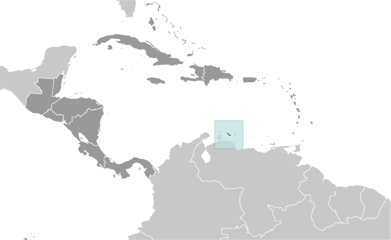
Caribbean, located in the Leeward Islands (northern) group; Dutch part of the island of Saint Martin in the Caribbean Sea; Sint Maarten lies east of the US Virgin Islands
Geographic coordinates:18 4 N, 63 4 W
Map references:Central America and the Caribbean
Area:total: 34 sq kmland: 34 sq kmwater: 0 sq kmnote: Dutch part of the island of Saint Martin
country comparison to the world: 236Area - comparative:one-fifth the size of Washington, DC
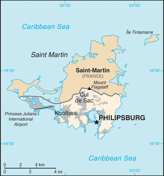
Land boundaries:total: 16 kmborder countries (1): Saint Martin (France) 16 kmCoastline:58.9 km (for entire island)Maritime claims:territorial sea: 12 nmexclusive economic zone: 200 nmClimate:tropical marine climate, ameliorated by northeast trade winds, results in moderate temperatures; average rainfall of 150 cm/year; hurricane season stretches from July to November
Terrain:low, hilly terrain, volcanic origin
Elevation:mean elevation: NAelevation extremes: 0 m lowest point: Caribbean Sea383 highest point: Mount FlagstaffNatural resources:fish, salt
Population distribution:most populous areas are Lower Prince's Quarter (north of Philipsburg), followed closely by Cul de SacNatural hazards:subject to hurricanes from July to November
Environment - current issues:scarcity of potable water (increasing percentage provided by desalination); inadequate solid waste management; pollution from construction, chemical runoff, and sewage harms reefs
Geography - note:the northern border is shared with the French overseas collectivity of Saint Martin; together, these two entities make up the smallest landmass in the world shared by two self-governing states
-
People and Society :: Sint Maarten
-
Population:42,677 (July 2018 est.)country comparison to the world: 212Languages:English (official) 67.5%, Spanish 12.9%, Creole 8.2%, Dutch (official) 4.2%, Papiamento (a Spanish-Portuguese-Dutch-English dialect) 2.2%, French 1.5%, other 3.5% (2001 census)Religions:Protestant 41.9% (Pentecostal 14.7%, Methodist 10.0%, Seventh Day Adventist 6.6%, Baptist 4.7%, Anglican 3.1%, other Protestant 2.8%), Roman Catholic 33.1%, Hindu 5.2%, Christian 4.1%, Jehovah's Witness 1.7%, Evangelical 1.4%, Muslim/Jewish 1.1%, other 1.3% (includes Buddhist, Sikh, Rastafarian), none 7.9%, no response 2.4% (2011 est.)Age structure:0-14 years: 18.5% (male 4,110 /female 3,785)15-24 years: 14.19% (male 3,049 /female 3,009)25-54 years: 40.93% (male 8,539 /female 8,930)55-64 years: 16.52% (male 3,356 /female 3,694)65 years and over: 9.85% (male 2,017 /female 2,188) (2018 est.)population pyramid:
 The World Factbook Field Image ModalCentral America :: Sint Maarten Print
 Image DescriptionThis is the population pyramid for Sint Maarten. A population pyramid illustrates the age and sex structure of a country's population and may provide insights about political and social stability, as well as economic development. The population is distributed along the horizontal axis, with males shown on the left and females on the right. The male and female populations are broken down into 5-year age groups represented as horizontal bars along the vertical axis, with the youngest age groups at the bottom and the oldest at the top. The shape of the population pyramid gradually evolves over time based on fertility, mortality, and international migration trends.
For additional information, please see the entry for Population pyramid on the Definitions and Notes page under the References tab.Median age:total: 41.2 yearsmale: 39.8 yearsfemale: 42.2 years (2018 est.)country comparison to the world: 43Population growth rate:1.39% (2018 est.)country comparison to the world: 80Birth rate:13.1 births/1,000 population (2018 est.)country comparison to the world: 147Death rate:5.4 deaths/1,000 population (2018 est.)country comparison to the world: 182Net migration rate:6.3 migrant(s)/1,000 population (2017 est.)country comparison to the world: 15Population distribution:most populous areas are Lower Prince's Quarter (north of Philipsburg), followed closely by Cul de SacUrbanization:urban population: 100% of total population (2018)rate of urbanization: 1.56% annual rate of change (2015-20 est.)Major urban areas - population:1327 PHILIPSBURG (capital) (2011)Sex ratio:at birth: 1.05 male(s)/female (2017 est.)0-14 years: 1.09 male(s)/female (2017 est.)15-24 years: 0.98 male(s)/female (2017 est.)25-54 years: 0.95 male(s)/female (2017 est.)55-64 years: 0.92 male(s)/female (2017 est.)65 years and over: 0.92 male(s)/female (2017 est.)total population: 0.98 male(s)/female (2017 est.)Infant mortality rate:total: 7.9 deaths/1,000 live births (2018 est.)male: 8.6 deaths/1,000 live births (2018 est.)female: 7.2 deaths/1,000 live births (2018 est.)country comparison to the world: 152Life expectancy at birth:total population: 78.5 years (2018 est.)male: 76.1 years (2018 est.)female: 80.9 years (2018 est.)country comparison to the world: 62Total fertility rate:2.04 children born/woman (2018 est.)country comparison to the world: 112HIV/AIDS - adult prevalence rate:NAHIV/AIDS - people living with HIV/AIDS:NAHIV/AIDS - deaths:NAMajor infectious diseases:note: active local transmission of Zika virus by Aedes species mosquitoes has been identified in this country (as of August 2016); it poses an important risk (a large number of cases possible) among US citizens if bitten by an infective mosquito; other less common ways to get Zika are through sex, via blood transfusion, or during pregnancy, in which the pregnant woman passes Zika virus to her fetus
-
Government :: Sint Maarten
-
Country name:conventional long form: noneconventional short form: Sint Maartenlocal long form: Land Sint Maarten (Dutch); Country of Sint Maarten (English)local short form: Sint Maarten (Dutch and English)former: Netherlands Antilles; Curacao and Dependenciesetymology: explorer Christopher COLUMBUS named the island after Saint MARTIN of Tours because the 11 November 1493 day of discovery was the saint's feast dayDependency status:
constituent country within the Kingdom of the Netherlands; full autonomy in internal affairs granted in 2010; Dutch Government responsible for defense and foreign affairs
Government type:parliamentary democracy (Estates of Sint Maarten) under a constitutional monarchy
Capital:name: Philipsburggeographic coordinates: 18 1 N, 63 2 Wtime difference: UTC-4 (1 hour ahead of Washington, DC, during Standard Time)Administrative divisions:none (part of the Kingdom of the Netherlands)
note: Sint Maarten is one of four constituent countries of the Kingdom of the Netherlands; the other three are the Netherlands, Aruba, and Curacao
Independence:none (part of the Kingdom of the Netherlands)
National holiday:King's Day (birthday of King WILLEM-ALEXANDER), 27 April (1967); note - King's or Queen's Day are observed on the ruling monarch's birthday; celebrated on 26 April if 27 April is a Sunday
Constitution:previous 1947, 1955; latest adopted 21 July 2010, entered into force 10 October 2010 (regulates governance of Sint Maarten but is subordinate to the Charter for the Kingdom of the Netherlands) (2018)Legal system:based on Dutch civil law system with some English common law influence
Citizenship:see the NetherlandsSuffrage:18 years of age; universal
Judicial branch:highest courts: Joint Court of Justice of Aruba, Curacao, Sint Maarten, and of Bonaire, Sint Eustatius and Saba or "Joint Court of Justice" (consists of the presiding judge, other members, and their substitutes); final appeals heard by the Supreme Court (in The Hague, Netherlands); note - prior to 2010, the Joint Court of Justice was the Common Court of Justice of the Netherlands Antilles and Arubajudge selection and term of office: Joint Court judges appointed by the monarch serve for lifesubordinate courts: Courts in First InstanceExecutive branch:chief of state: King WILLEM-ALEXANDER of the Netherlands (since 30 April 2013); represented by Governor General Eugene HOLIDAY (since 10 October 2010)head of government: Prime Minister Leona MARLIN-ROMEO (since 15 January 2018)cabinet: Cabinet nominated by the prime minister and appointed by the governor-generalelections/appointments: the monarch is hereditary; governor general appointed by the monarch for a 6-year term; following parliamentary elections, the leader of the majority party usually elected prime minister by ParliamentLegislative branch:description: unicameral parliament or Staten (15 seats; members directly elected by proportional representation vote to serve 4-year terms)elections: last held 26 February 2018 (next to be held in 2022)election results: percent of vote by party - UD 42.4%, NA 30.5%, US Party 13.2%, SMCP 8.7%; seats by party - UD 7, NA 5, US Party 2, SMCP 1Political parties and leaders:National Alliance or NA [William MARLIN]
Sint Maarten Christian Party or SMCP [Wycliffe SMITH]
United Democrats Party or UD [Theodore HEYLIGER]
United Sint Maarten Party or US Party [Frans RICHARDSON]International organization participation:Caricom (observer), ILO, Interpol, UNESCO (associate), UPU, WMO
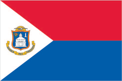
Diplomatic representation in the US:none (represented by the Kingdom of the Netherlands)Diplomatic representation from the US:the US does not have an embassy in Sint Maarten; the Consul General to Curacao is accredited to Sint MaartenFlag description:two equal horizontal bands of red (top) and blue with a white isosceles triangle based on the hoist side; the center of the triangle displays the Sint Maarten coat of arms; the arms consist of an orange-bordered blue shield prominently displaying the white court house in Philipsburg, as well as a bouquet of yellow sage (the national flower) in the upper left, and the silhouette of a Dutch-French friendship monument in the upper right; the shield is surmounted by a yellow rising sun in front of which is a brown pelican in flight; a yellow scroll below the shield bears the motto: SEMPER PROGREDIENS (Always Progressing); the three main colors are identical to those on the Dutch flagnote: the flag somewhat resembles that of the Philippines but with the main red and blue bands reversed; the banner more closely evokes the wartime Philippine flagNational symbol(s):brown pelican, yellow sage (flower); national colors: red, white, blue
National anthem:name: O Sweet Saint Martin's Landlyrics/music: Gerard KEMPSnote: the song, written in 1958, is used as an unofficial anthem for the entire island (both French and Dutch sides); as a collectivity of France, in addition to the local anthem, "La Marseillaise" is official on the French side (see France); as a constituent part of the Kingdom of the Netherlands, in addition to the local anthem, "Het Wilhelmus" is official on the Dutch side (see Netherlands)
-
Economy :: Sint Maarten
-
Economy - overview:The economy of Sint Maarten centers around tourism with nearly four-fifths of the labor force engaged in this sector. Nearly 1.8 million visitors came to the island by cruise ship and roughly 500,000 visitors arrived through Princess Juliana International Airport in 2013. Cruise ships and yachts also call on Sint Maarten's numerous ports and harbors. Limited agriculture and local fishing means that almost all food must be imported. Energy resources and manufactured goods are also imported. Sint Maarten had the highest per capita income among the five islands that formerly comprised the Netherlands Antilles.GDP (purchasing power parity):$365.8 million (2014 est.)$353.5 million (2013 est.)$339.6 million (2012 est.)note: data are in 2014 US dollarscountry comparison to the world: 214GDP (official exchange rate):$304.1 million (2014 est.)GDP - real growth rate:3.6% (2014 est.)4.1% (2013 est.)1.9% (2012 est.)country comparison to the world: 97GDP - per capita (PPP):$66,800 (2014 est.)$65,500 (2013 est.)$63,900 (2012 est.)note: data are in 2015 US dollarscountry comparison to the world: 14GDP - composition, by sector of origin:agriculture: 0.4% (2008 est.)industry: 18.3% (2008 est.)services: 81.3% (2008 est.)Agriculture - products:sugarIndustries:tourism, light industryLabor force:23,200 (2008 est.)country comparison to the world: 210Labor force - by occupation:agriculture: 1.1%industry: 15.2%services: 83.7% (2008 est.)Unemployment rate:12% (2012 est.)10.6% (2008 est.)country comparison to the world: 160Inflation rate (consumer prices):4% (2012 est.)0.7% (2009 est.)country comparison to the world: 157Exports - commodities:sugarExchange rates:Netherlands Antillean guilders (ANG) per US dollar -1.79 (2017 est.)1.79 (2016 est.)1.79 (2015 est.)1.79 (2014 est.)1.79 (2013 est.)
-
Energy :: Sint Maarten
-
Electricity - production:304.3 million kWh (2008 est.)country comparison to the world: 181Crude oil - exports:0 bbl/day (2015 est.)country comparison to the world: 193Crude oil - imports:0 bbl/day (2015 est.)country comparison to the world: 195Refined petroleum products - production:0 bbl/day (2015 est.)country comparison to the world: 201Refined petroleum products - consumption:10,600 bbl/day (2016 est.)country comparison to the world: 161Refined petroleum products - exports:0 bbl/day (2015 est.)country comparison to the world: 202Refined petroleum products - imports:10,440 bbl/day (2015 est.)country comparison to the world: 148
-
Communications :: Sint Maarten
-
Telephone system:general assessment: generally adequate facilities (2010)domestic: extensive interisland microwave radio relay links (2010)international: country code - 1-721; the Americas Region Caribbean Ring System (ARCOS-1) and the Americas-2 submarine cable systems provide connectivity to Central America, parts of South America, the Caribbean, and the U.S.; satellite earth stations - 2 Intelsat (Atlantic Ocean) (2010)Internet country code:
.sx; note - IANA has designated .sx for Sint Maarten, but has not yet assigned it to a sponsoring organization
-
Transportation :: Sint Maarten
-
Airports:1 (2013)country comparison to the world: 236Airports - with paved runways:total: 1 (2017)1,524 to 2,437 m: 1 (2017)
note: Princess Juliana International Airport (SXM) was severely damaged on 6 September 2017 by hurricane Irma, but resumed commercial operations on 10 October 2017
Roadways:total: 53 kmcountry comparison to the world: 219Ports and terminals:major seaport(s): Philipsburgoil terminal(s): Coles Bay oil terminal -
Military and Security :: Sint Maarten
-
Military branches:no regular military forces (2012)Military - note:
defense is the responsibility of the Kingdom of the Netherlands
Central America ::
Sint Maarten