Location:
This entry identifies the country's regional location, neighboring countries, and adjacent bodies of water.

Oceania, group of islands in the South Pacific Ocean, about halfway between Hawaii and New Zealand
Geographic coordinates:
This entry includes rounded latitude and longitude figures for the centroid or center point of a country expressed in degrees and minutes; it is based on the locations provided in the Geographic Names Server (GNS), maintained by the National Geospatial-Intelligence Agency on behalf of the US Board on Geographic Names.
Map references:
This entry includes the name of the Factbook reference map on which a country may be found. Note that boundary representations on these maps are not necessarily authoritative. The entry on Geographic coordinates may be helpful in finding some smaller countries.
Area:
This entry includes three subfields. Total area is the sum of all land and water areas delimited by international boundaries and/or coastlines. Land area is the aggregate of all surfaces delimited by international boundaries and/or coastlines, excluding inland water bodies (lakes, reservoirs, rivers). Water area is the sum of the surfaces of all inland water bodies, such as lakes, reservoirs, or rivers, as delimited by international boundaries and/or coastlines.
total:
224 sq km
land:
224 sq km
water:
0 sq km
note: includes Rose Island and Swains Island
country comparison to the world:
216
Area - comparative:
This entry provides an area comparison based on total area equivalents. Most entities are compared with the entire US or one of the 50 states based on area measurements (1990 revised) provided by the US Bureau of the Census. The smaller entities are compared with Washington, DC (178 sq km, 69 sq mi) or The Mall in Washington, DC (0.59 sq km, 0.23 sq mi, 146 acres).
slightly larger than Washington, DC
Land boundaries:
This entry contains the total length of all land boundaries and the individual lengths for each of the contiguous border countries. When available, official lengths published by national statistical agencies are used. Because surveying methods may differ, country border lengths reported by contiguous countries may differ.
Coastline:
This entry gives the total length of the boundary between the land area (including islands) and the sea.
Maritime claims:
This entry includes the following claims, the definitions of which are excerpted from the United Nations Convention on the Law of the Sea (UNCLOS), which alone contains the full and definitive descriptions: territorial sea - the sovereignty of a coastal state extends beyond its land territory and internal waters to an adjacent belt of sea, described as the territorial sea in the UNCLOS (Part II); this sovereignty extends to the air space over the territorial sea as well as its underlying s . . .
more
territorial sea:
12
nm
exclusive economic zone:
200
nm
Climate:
This entry includes a brief description of typical weather regimes throughout the year; in the Word entry only, it includes four subfields that describe climate extremes:ten driest places on earth (average annual precipitation) describes the annual average precipitation measured in both millimeters and inches for selected countries with climate extremes.
ten wettest places on earth (average annual precipitation) describes the annual average precipitation measured in both millimeters and i . . .
more
tropical marine, moderated by southeast trade winds; annual rainfall averages about 3 m; rainy season (November to April), dry season (May to October); little seasonal temperature variation
Terrain:
This entry contains a brief description of the topography.
five volcanic islands with rugged peaks and limited coastal plains, two coral atolls (Rose Island, Swains Island)
Elevation:
This entry includes the mean elevation and elevation extremes, lowest point and highest point.
lowest point:
Pacific Ocean 0 m
highest point:
Lata Mountain 964 m
Natural resources:
This entry lists a country's mineral, petroleum, hydropower, and other resources of commercial importance, such as rare earth elements (REEs). In general, products appear only if they make a significant contribution to the economy, or are likely to do so in the future.
Land use:
This entry contains the percentage shares of total land area for three different types of land use: agricultural land, forest, and other; agricultural land is further divided into arable land - land cultivated for crops like wheat, maize, and rice that are replanted after each harvest, permanent crops - land cultivated for crops like citrus, coffee, and rubber that are not replanted after each harvest, and includes land under flowering shrubs, fruit trees, nut trees, and vines, and permane . . .
more
agricultural land:
21.9%
(2016 est.)
arable land:
13.4%
(2016 est.)
/
permanent crops:
8.5%
(2016 est.)
/
permanent pasture:
0%
(2016 est.)
forest:
78.1%
(2016 est.)
other:
0%
(2016 est.)
Irrigated land:
This entry gives the number of square kilometers of land area that is artificially supplied with water.
Natural hazards:
This entry lists potential natural disasters. For countries where volcanic activity is common, a volcanism subfield highlights historically active volcanoes.
cyclones common from December to March
volcanism: limited volcanic activity on the Ofu and Olosega Islands; neither has erupted since the 19th century
Environment - current issues:
This entry lists the most pressing and important environmental problems. The following terms and abbreviations are used throughout the entry:
Acidification - the lowering of soil and water pH due to acid precipitation and deposition usually through precipitation; this process disrupts ecosystem nutrient flows and may kill freshwater fish and plants dependent on more neutral or alkaline conditions (see acid rain).
Acid rain - characterized as containing harmful levels of sulfur dioxi . . .
more
limited supply of drinking water; pollution; waste disposal; coastal and stream alteration; soil erosion
Geography - note:
This entry includes miscellaneous geographic information of significance not included elsewhere.
Pago Pago has one of the best natural deepwater harbors in the South Pacific Ocean, sheltered by shape from rough seas and protected by peripheral mountains from high winds; strategic location in the South Pacific Ocean
Population:
This entry gives an estimate from the US Bureau of the Census based on statistics from population censuses, vital statistics registration systems, or sample surveys pertaining to the recent past and on assumptions about future trends. The total population presents one overall measure of the potential impact of the country on the world and within its region. Note: Starting with the 1993 Factbook, demographic estimates for some countries (mostly African) have explicitly taken into account t . . .
more
50,826
(July 2018 est.)
country comparison to the world:
211
Nationality:
This entry provides the identifying terms for citizens - noun and adjective.
noun:
American Samoan(s) (US nationals)
adjective:
American Samoan
Ethnic groups:
This entry provides an ordered listing of ethnic groups starting with the largest and normally includes the percent of total population.
Pacific Islander 92.6% (includes Samoan 88.9%, Tongan 2.9%, other .8%), Asian 3.6% (includes Filipino 2.2%, other 1.4%), mixed 2.7%, other 1.2%
(2010 est.)
note: data represent population by ethnic origin or race
Languages:
This entry provides a listing of languages spoken in each country and specifies any that are official national or regional languages. When data is available, the languages spoken in each country are broken down according to the percent of the total population speaking each language as a first language. For those countries without available data, languages are listed in rank order based on prevalence, starting with the most-spoken language.
Samoan 88.6% (closely related to Hawaiian and other Polynesian languages), English 3.9%, Tongan 2.7%, other Pacific islander 3%, other 1.8%
(2010 est.)
note: most people are bilingual
Religions:
This entry is an ordered listing of religions by adherents starting with the largest group and sometimes includes the percent of total population. The core characteristics and beliefs of the world's major religions are described below. Baha'i - Founded by Mirza Husayn-Ali (known as Baha'u'llah) in Iran in 1852, Baha'i faith emphasizes monotheism and believes in one eternal transcendent God. Its guiding focus is to encourage the unity of all peoples on the earth so that justice and peace m . . .
more
Christian 98.3%, other 1%, unaffiliated 0.7%
(2010 est.)
Age structure:
This entry provides the distribution of the population according to age. Information is included by sex and age group as follows: 0-14 years (children), 15-24 years (early working age), 25-54 years (prime working age), 55-64 years (mature working age), 65 years and over (elderly). The age structure of a population affects a nation's key socioeconomic issues. Countries with young populations (high percentage under age 15) need to invest more in schools, while countries with older population . . .
more
0-14 years:
29.59%
(male 7,732 /female 7,305)
15-24 years:
18.42%
(male 4,695 /female 4,669)
25-54 years:
36.79%
(male 9,255 /female 9,442)
55-64 years:
8.96%
(male 2,244 /female 2,310)
65 years and over:
6.24%
(male 1,486 /female 1,688)
(2018 est.)
population pyramid:

Australia - Oceania
::
American Samoa
Print
This is the population pyramid for American Samoa. A population pyramid illustrates the age and sex structure of a country's population and may provide insights about political and social stability, as well as economic development. The population is distributed along the horizontal axis, with males shown on the left and females on the right. The male and female populations are broken down into 5-year age groups represented as horizontal bars along the vertical axis, with the youngest age groups at the bottom and the oldest at the top. The shape of the population pyramid gradually evolves over time based on fertility, mortality, and international migration trends.
For additional information, please see the entry for Population pyramid on the Definitions and Notes page under the References tab.
Population growth rate:
The average annual percent change in the population, resulting from a surplus (or deficit) of births over deaths and the balance of migrants entering and leaving a country. The rate may be positive or negative. The growth rate is a factor in determining how great a burden would be imposed on a country by the changing needs of its people for infrastructure (e.g., schools, hospitals, housing, roads), resources (e.g., food, water, electricity), and jobs. Rapid population growth can be seen as . . .
more
-1.35%
(2018 est.)
country comparison to the world:
231
Birth rate:
This entry gives the average annual number of births during a year per 1,000 persons in the population at midyear; also known as crude birth rate. The birth rate is usually the dominant factor in determining the rate of population growth. It depends on both the level of fertility and the age structure of the population.
19 births/1,000 population
(2018 est.)
country comparison to the world:
83
Death rate:
This entry gives the average annual number of deaths during a year per 1,000 population at midyear; also known as crude death rate. The death rate, while only a rough indicator of the mortality situation in a country, accurately indicates the current mortality impact on population growth. This indicator is significantly affected by age distribution, and most countries will eventually show a rise in the overall death rate, in spite of continued decline in mortality at all ages, as declining . . .
more
5.9 deaths/1,000 population
(2018 est.)
country comparison to the world:
166
Net migration rate:
This entry includes the figure for the difference between the number of persons entering and leaving a country during the year per 1,000 persons (based on midyear population). An excess of persons entering the country is referred to as net immigration (e.g., 3.56 migrants/1,000 population); an excess of persons leaving the country as net emigration (e.g., -9.26 migrants/1,000 population). The net migration rate indicates the contribution of migration to the overall level of population chan . . .
more
-26.6 migrant(s)/1,000 population
(2018 est.)
country comparison to the world:
225
Urbanization:
This entry provides two measures of the degree of urbanization of a population. The first, urban population, describes the percentage of the total population living in urban areas, as defined by the country. The second, rate of urbanization, describes the projected average rate of change of the size of the urban population over the given period of time. It is possible for a country with a 100% urban population to still display a change in the rate of urbanization (up or down). For example . . .
more
urban population:
87.1% of total population
(2019)
rate of urbanization:
0.07% annual rate of change
(2015-20 est.)
Major urban areas - population:
This entry provides the population of the capital and up to six major cities defined as urban agglomerations with populations of at least 750,000 people. An urban agglomeration is defined as comprising the city or town proper and also the suburban fringe or thickly settled territory lying outside of, but adjacent to, the boundaries of the city. For smaller countries, lacking urban centers of 750,000 or more, only the population of the capital is presented.
49,000 PAGO PAGO (capital)
(2018)
Sex ratio:
This entry includes the number of males for each female in five age groups - at birth, under 15 years, 15-64 years, 65 years and over, and for the total population. Sex ratio at birth has recently emerged as an indicator of certain kinds of sex discrimination in some countries. For instance, high sex ratios at birth in some Asian countries are now attributed to sex-selective abortion and infanticide due to a strong preference for sons. This will affect future marriage patterns and fertilit . . .
more
at birth:
1.06 male(s)/female
0-14 years:
1.06 male(s)/female
15-24 years:
1.01 male(s)/female
25-54 years:
0.98 male(s)/female
55-64 years:
0.97 male(s)/female
65 years and over:
0.88 male(s)/female
total population:
1 male(s)/female
(2018 est.)
Infant mortality rate:
This entry gives the number of deaths of infants under one year old in a given year per 1,000 live births in the same year. This rate is often used as an indicator of the level of health in a country.
total:
10.8 deaths/1,000 live births
(2018 est.)
male:
12.7 deaths/1,000 live births
female:
8.9 deaths/1,000 live births
country comparison to the world:
128
Life expectancy at birth:
This entry contains the average number of years to be lived by a group of people born in the same year, if mortality at each age remains constant in the future. Life expectancy at birth is also a measure of overall quality of life in a country and summarizes the mortality at all ages. It can also be thought of as indicating the potential return on investment in human capital and is necessary for the calculation of various actuarial measures.
total population:
73.9 years
(2018 est.)
male:
71.6 years
female:
76.2 years
country comparison to the world:
131
Total fertility rate:
This entry gives a figure for the average number of children that would be born per woman if all women lived to the end of their childbearing years and bore children according to a given fertility rate at each age. The total fertility rate (TFR) is a more direct measure of the level of fertility than the crude birth rate, since it refers to births per woman. This indicator shows the potential for population change in the country. A rate of two children per woman is considered the replaceme . . .
more
2.57 children born/woman
(2018 est.)
country comparison to the world:
75
Drinking water source:
This entry provides information about access to improved or unimproved drinking water sources available to segments of the population of a country. Improved drinking water - use of any of the following sources: piped water into dwelling, yard, or plot; public tap or standpipe; tubewell or borehole; protected dug well; protected spring; or rainwater collection. Unimproved drinking water - use of any of the following sources: unprotected dug well; unprotected spring; cart with small tank or . . .
more
improved:
urban:
100% of population
rural:
100% of population
total:
100% of population
unimproved:
urban:
0% of population
rural:
0% of population
total:
0% of population
(2015 est.)
Sanitation facility access:
This entry provides information about access to improved or unimproved sanitation facilities available to segments of the population of a country. Improved sanitation - use of any of the following facilities: flush or pour-flush to a piped sewer system, septic tank or pit latrine; ventilated improved pit (VIP) latrine; pit latrine with slab; or a composting toilet. Unimproved sanitation - use of any of the following facilities: flush or pour-flush not piped to a sewer system, septic tank . . .
more
improved:
urban:
62.5% of population
(2015 est.)
rural:
62.5% of population
(2015 est.)
total:
62.5% of population
(2015 est.)
unimproved:
urban:
37.5% of population
(2015 est.)
rural:
37.5% of population
(2015 est.)
total:
37.5% of population
(2015 est.)
HIV/AIDS - adult prevalence rate:
This entry gives an estimate of the percentage of adults (aged 15-49) living with HIV/AIDS. The adult prevalence rate is calculated by dividing the estimated number of adults living with HIV/AIDS at yearend by the total adult population at yearend.
HIV/AIDS - people living with HIV/AIDS:
This entry gives an estimate of all people (adults and children) alive at yearend with HIV infection, whether or not they have developed symptoms of AIDS.
HIV/AIDS - deaths:
This entry gives an estimate of the number of adults and children who died of AIDS during a given calendar year.
Major infectious diseases:
This entry lists major infectious diseases likely to be encountered in countries where the risk of such diseases is assessed to be very high as compared to the United States. These infectious diseases represent risks to US government personnel traveling to the specified country for a period of less than three years. The degree of risk is assessed by considering the foreign nature of these infectious diseases, their severity, and the probability of being affected by the diseases present. Th . . .
more
note: active local transmission of Zika virus by Aedes species mosquitoes has been identified in this country (as of August 2016); it poses an important risk (a large number of cases possible) among US citizens if bitten by an infective mosquito; other less common ways to get Zika are through sex, via blood transfusion, or during pregnancy, in which the pregnant woman passes Zika virus to her fetus
Country name:
This entry includes all forms of the country's name approved by the US Board on Geographic Names (Italy is used as an example): conventional long form (Italian Republic), conventional short form (Italy), local long form (Repubblica Italiana), local short form (Italia), former (Kingdom of Italy), as well as the abbreviation. Also see the Terminology note.
conventional long form:
American Samoa
conventional short form:
American Samoa
abbreviation:
AS
etymology:
the name Samoa is composed of two parts, "sa" meaning "sacred" and "moa" meaning "center," so the name can mean Holy Center; alternatively, it can mean "place of the sacred moa bird" of Polynesian mythology
Dependency status:
This entry describes the formal relationship between a particular nonindependent entity and an independent state.
unincorporated unorganized territory of the US; administered by the Office of Insular Affairs, US Department of the Interior
Government type:
This entry gives the basic form of government. Definitions of the major governmental terms are as follows. (Note that for some countries more than one definition applies.):
Absolute monarchy - a form of government where the monarch rules unhindered, i.e., without any laws, constitution, or legally organized opposition.
Anarchy - a condition of lawlessness or political disorder brought about by the absence of governmental authority.
Authoritarian - a form of government in whic . . .
more
republican form of government with separate executive, legislative, and judicial branches; unincorporated unorganized territory of the US with local self-government
Capital:
This entry gives the name of the seat of government, its geographic coordinates, the time difference relative to Coordinated Universal Time (UTC) and the time observed in Washington, DC, and, if applicable, information on daylight saving time (DST). Where appropriate, a special note has been added to highlight those countries that have multiple time zones.
name:
Pago Pago
geographic coordinates:
14 16 S, 170 42 W
time difference:
UTC-11 (6 hours behind Washington, DC, during Standard Time)
note: pronounced "pahn-go pahn-go"
Administrative divisions:
This entry generally gives the numbers, designatory terms, and first-order administrative divisions as approved by the US Board on Geographic Names (BGN). Changes that have been reported but not yet acted on by the BGN are noted. Geographic names conform to spellings approved by the BGN with the exception of the omission of diacritical marks and special characters.
none (territory of the US); there are no first-order administrative divisions as defined by the US Government, but there are 3 districts and 2 islands* at the second order; Eastern, Manu'a, Rose Island*, Swains Island*, Western
Independence:
For most countries, this entry gives the date that sovereignty was achieved and from which nation, empire, or trusteeship. For the other countries, the date given may not represent "independence" in the strict sense, but rather some significant nationhood event such as the traditional founding date or the date of unification, federation, confederation, establishment, fundamental change in the form of government, or state succession. For a number of countries, the establishment of statehood . . .
more
none (territory of the US)
National holiday:
This entry gives the primary national day of celebration - usually independence day.
Flag Day, 17 April (1900)
Constitution:
This entry provides information on a country’s constitution and includes two subfields. The history subfield includes the dates of previous constitutions and the main steps and dates in formulating and implementing the latest constitution. For countries with 1-3 previous constitutions, the years are listed; for those with 4-9 previous, the entry is listed as “several previous,” and for those with 10 or more, the entry is “many previous.” The amendments subfield summarizes the process of am . . .
more
history:
adopted 17 October 1960; revised 1 July 1967
amendments:
proposed by either house of the Legislative Assembly; passage requires three-fifths majority vote by the membership of each house, approval in a referendum, and approval by the US Secretary of the Interior; amended 1971, 1977, 1979
(2017)
Legal system:
This entry provides the description of a country's legal system. A statement on judicial review of legislative acts is also included for a number of countries. The legal systems of nearly all countries are generally modeled upon elements of five main types: civil law (including French law, the Napoleonic Code, Roman law, Roman-Dutch law, and Spanish law); common law (including United State law); customary law; mixed or pluralistic law; and religious law (including Islamic law). An addition . . .
more
mixed legal system of US common law and customary law
Citizenship:
This entry provides information related to the acquisition and exercise of citizenship; it includes four subfields: citizenship by birth describes the acquisition of citizenship based on place of birth, known as Jus soli, regardless of the citizenship of parents. citizenship by descent only describes the acquisition of citizenship based on the principle of Jus sanguinis, or by descent, where at least one parent is a citizen of the state and being born within the territorial limits of the s . . .
more
see United States
Note: in accordance with US Code Title 8, Section 1408, persons born in American Samoa are US nationals but not US citizens
Suffrage:
This entry gives the age at enfranchisement and whether the right to vote is universal or restricted.
18 years of age; universal
Executive branch:
This entry includes five subentries: chief of state; head of government; cabinet; elections/appointments; election results. Chief of state includes the name, title, and beginning date in office of the titular leader of the country who represents the state at official and ceremonial functions but may not be involved with the day-to-day activities of the government. Head of government includes the name, title of the top executive designated to manage the executive branch of the government, a . . .
more
chief of state:
President Donald J. TRUMP (since 20 January 2017); Vice President Michael R. PENCE (since 20 January 2017)
head of government:
Governor Lolo Matalasi MOLIGA (since 3 January 2013)
cabinet:
Cabinet consists of 12 department directors appointed by the governor with the consent of the Legislature or Fono
elections/appointments:
president and vice president indirectly elected on the same ballot by an Electoral College of 'electors' chosen from each state to serve a 4-year term (eligible for a second term); under the US Constitution, residents of unincorporated territories, such as American Samoa, do not vote in elections for US president and vice president; however, they may vote in Democratic and Republican presidential primary elections; governor and lieutenant governor directly elected on the same ballot by absolute majority popular vote in 2 rounds if needed for a 4-year term (eligible for a second term); election last held on 8 November 2016 (next to be held in November 2020)
election results:
Lolo Matalasi MOLIGA reelected governor in first round; percent of vote - Lolo Matalasi MOLIGA (independent) 60.2%, Faoa Aitofele SUNIA (Democratic Party) 35.8%, Tuika TUIKA (independent) 4%
Legislative branch:
This entry has three subfields. The description subfield provides the legislative structure (unicameral – single house; bicameral – an upper and a lower house); formal name(s); number of member seats; types of constituencies or voting districts (single seat, multi-seat, nationwide); electoral voting system(s); and member term of office. The elections subfield includes the dates of the last election and next election. The election results subfield lists percent of vote by party/coalition an . . .
more
description:
bicameral Legislature or Fono consists of:
Senate (18 seats; members indirectly selected by regional governing councils to serve 4-year terms)
House of Representatives (21 seats; 20 members directly elected by simple majority vote and 1 decided by public meeting on Swains Island; members serve 2-year terms)
elections:
Senate - last held on 8 November 2016 (next to be held in November 2020)
House of Representatives - last held on 6 November 2018 (next to be held in November 2020)
election results:
Senate - percent of vote by party - NA; seats by party - independent 18; composition - men 17, women 1, percent of women 9.5%
House of Representatives - percent of vote by party - NA; seats by party - NA; composition - men 14, women 7, percent of women 33.3%; note - total percent of women in Legislature 20.5%
note: American Samoa elects 1 member by simple majority vote to serve a 2-year term as a delegate to the US House of Representatives; the delegate can vote when serving on a committee and when the House meets as the Committee of the Whole House, but not when legislation is submitted for a “full floor” House vote; election of delegate last held on 6 November 2018 (next to be held in November 2020)
Judicial branch:
This entry includes three subfields. The highest court(s) subfield includes the name(s) of a country's highest level court(s), the number and titles of the judges, and the types of cases heard by the court, which commonly are based on civil, criminal, administrative, and constitutional law. A number of countries have separate constitutional courts. The judge selection and term of office subfield includes the organizations and associated officials responsible for nominating and appointing j . . .
more
highest courts:
High Court of American Samoa (consists of the chief justice, associate chief justice, and 6 Samoan associate judges and organized into trial, family, drug, and appellate divisions); note - American Samoa has no US federal courts
judge selection and term of office:
chief justice and associate chief justice appointed by the US Secretary of the Interior to serve for life; Samoan associate judges appointed by the governor to serve for life
subordinate courts:
district and village courts
Political parties and leaders:
This entry includes a listing of significant political parties, coalitions, and electoral lists as of each country's last legislative election, unless otherwise noted.
Democratic Party [Fagafaga Daniel LANGKILDE, chairman]
Republican Party [William SWORD, chairman]
International organization participation:
This entry lists in alphabetical order by abbreviation those international organizations in which the subject country is a member or participates in some other way.
AOSIS (observer), Interpol (subbureau), IOC, PIF (observer), SPC
Diplomatic representation in the US:
This entry includes the chief of mission, chancery address, telephone, FAX, consulate general locations, and consulate locations. The use of the annotated title Appointed Ambassador refers to a new ambassador who has presented his/her credentials to the secretary of state but not the US president. Such ambassadors fulfill all diplomatic functions except meeting with or appearing at functions attended by the president until such time as they formally present their credentials at a White Hou . . .
more
none (territory of the US)
Diplomatic representation from the US:
This entry includes the chief of mission, embassy address, mailing address, telephone number, FAX number, branch office locations, consulate general locations, and consulate locations.
none (territory of the US)
Flag description:
This entry provides a written flag description produced from actual flags or the best information available at the time the entry was written. The flags of independent states are used by their dependencies unless there is an officially recognized local flag. Some disputed and other areas do not have flags.
blue, with a white triangle edged in red that is based on the fly side and extends to the hoist side; a brown and white American bald eagle flying toward the hoist side is carrying 2 traditional Samoan symbols of authority, a war club known as a "fa'alaufa'i" (upper; left talon), and a coconut-fiber fly whisk known as a "fue" (lower; right talon); the combination of symbols broadly mimics that seen on the US Great Seal and reflects the relationship between the US and American Samoa
National symbol(s):
A national symbol is a faunal, floral, or other abstract representation - or some distinctive object - that over time has come to be closely identified with a country or entity. Not all countries have national symbols; a few countries have more than one.
a fue (coconut fiber fly whisk; representing wisdom) crossed with a to'oto'o (staff; representing authority); national colors: red, white, blue
National anthem:
A generally patriotic musical composition - usually in the form of a song or hymn of praise - that evokes and eulogizes the history, traditions, or struggles of a nation or its people. National anthems can be officially recognized as a national song by a country's constitution or by an enacted law, or simply by tradition. Although most anthems contain lyrics, some do not.
name:
"Amerika Samoa" (American Samoa)
lyrics/music:
Mariota Tiumalu TUIASOSOPO/Napoleon Andrew TUITELELEAPAGA
note: local anthem adopted 1950; as a territory of the United States, "The Star-Spangled Banner" is official (see United States)
Economy - overview:
This entry briefly describes the type of economy, including the degree of market orientation, the level of economic development, the most important natural resources, and the unique areas of specialization. It also characterizes major economic events and policy changes in the most recent 12 months and may include a statement about one or two key future macroeconomic trends.
American Samoa s a traditional Polynesian economy in which more than 90% of the land is communally owned. Economic activity is strongly linked to the US with which American Samoa conducts most of its commerce. Tuna fishing and processing are the backbone of the private sector with processed fish products as the primary exports. The fish processing business accounted for 15.5% of employment in 2015.
In late September 2009, an earthquake and the resulting tsunami devastated American Samoa and nearby Samoa, disrupting transportation and power generation, and resulting in about 200 deaths. The US Federal Emergency Management Agency oversaw a relief program of nearly $25 million. Transfers from the US Government add substantially to American Samoa's economic well-being.
Attempts by the government to develop a larger and broader economy are restrained by Samoa's remote location, its limited transportation, and its devastating hurricanes. Tourism has some potential as a source of income and jobs.
GDP (purchasing power parity):
This entry gives the gross domestic product (GDP) or value of all final goods and services produced within a nation in a given year. A nation's GDP at purchasing power parity (PPP) exchange rates is the sum value of all goods and services produced in the country valued at prices prevailing in the United States in the year noted. This is the measure most economists prefer when looking at per-capita welfare and when comparing living conditions or use of resources across countries. The measur . . .
more
$658 million
(2016 est.)
$674.9 million
(2015 est.)
$666.9 million
(2014 est.)
note: data are in 2016 US dollars
country comparison to the world:
209
GDP (official exchange rate):
This entry gives the gross domestic product (GDP) or value of all final goods and services produced within a nation in a given year. A nation's GDP at official exchange rates (OER) is the home-currency-denominated annual GDP figure divided by the bilateral average US exchange rate with that country in that year. The measure is simple to compute and gives a precise measure of the value of output. Many economists prefer this measure when gauging the economic power an economy maintains vis- . . .
more
$658 million
(2016 est.)
(2016 est.)
GDP - real growth rate:
This entry gives GDP growth on an annual basis adjusted for inflation and expressed as a percent. The growth rates are year-over-year, and not compounded.
-2.5%
(2016 est.)
1.2%
(2015 est.)
1%
(2014 est.)
country comparison to the world:
208
GDP - per capita (PPP):
This entry shows GDP on a purchasing power parity basis divided by population as of 1 July for the same year.
$11,200
(2016 est.)
$11,300
(2015 est.)
$11,200
(2014 est.)
country comparison to the world:
134
GDP - composition, by end use:
This entry shows who does the spending in an economy: consumers, businesses, government, and foreigners. The distribution gives the percentage contribution to total GDP of household consumption, government consumption, investment in fixed capital, investment in inventories, exports of goods and services, and imports of goods and services, and will total 100 percent of GDP if the data are complete. household consumption consists of expenditures by resident households, and by nonprofit insti . . .
more
household consumption:
66.4%
(2016 est.)
government consumption:
49.7%
(2016 est.)
investment in fixed capital:
7.3%
(2016 est.)
investment in inventories:
5.1%
(2016 est.)
exports of goods and services:
65%
(2016 est.)
imports of goods and services:
-93.5%
(2016 est.)
GDP - composition, by sector of origin:
This entry shows where production takes place in an economy. The distribution gives the percentage contribution of agriculture, industry, and services to total GDP, and will total 100 percent of GDP if the data are complete. Agriculture includes farming, fishing, and forestry. Industry includes mining, manufacturing, energy production, and construction. Services cover government activities, communications, transportation, finance, and all other private economic activities that do not prod . . .
more
agriculture:
27.4%
(2012)
industry:
12.4%
(2012)
services:
60.2%
(2012)
Agriculture - products:
This entry is an ordered listing of major crops and products starting with the most important.
bananas, coconuts, vegetables, taro, breadfruit, yams, copra, pineapples, papayas; dairy products, livestock
Industries:
This entry provides a rank ordering of industries starting with the largest by value of annual output.
tuna canneries (largely supplied by foreign fishing vessels), handicrafts
Labor force:
This entry contains the total labor force figure.
17,850
(2015 est.)
country comparison to the world:
213
Labor force - by occupation:
This entry lists the percentage distribution of the labor force by sector of occupation. Agriculture includes farming, fishing, and forestry. Industry includes mining, manufacturing, energy production, and construction. Services cover government activities, communications, transportation, finance, and all other economic activities that do not produce material goods. The distribution will total less than 100 percent if the data are incomplete and may range from 99-101 percent due to rounding.
more
agriculture:
NA
industry:
15.5%
services:
46.4%
(2015 est.)
Unemployment rate:
This entry contains the percent of the labor force that is without jobs. Substantial underemployment might be noted.
29.8%
(2005)
country comparison to the world:
206
Population below poverty line:
National estimates of the percentage of the population falling below the poverty line are based on surveys of sub-groups, with the results weighted by the number of people in each group. Definitions of poverty vary considerably among nations. For example, rich nations generally employ more generous standards of poverty than poor nations.
Household income or consumption by percentage share:
Data on household income or consumption come from household surveys, the results adjusted for household size. Nations use different standards and procedures in collecting and adjusting the data. Surveys based on income will normally show a more unequal distribution than surveys based on consumption. The quality of surveys is improving with time, yet caution is still necessary in making inter-country comparisons.
lowest 10%:
NA
highest 10%:
NA
Budget:
This entry includes revenues, expenditures, and capital expenditures. These figures are calculated on an exchange rate basis, i.e., not in purchasing power parity (PPP) terms.
revenues:
249 million
(2016 est.)
expenditures:
262.5 million
(2016 est.)
Taxes and other revenues:
This entry records total taxes and other revenues received by the national government during the time period indicated, expressed as a percent of GDP. Taxes include personal and corporate income taxes, value added taxes, excise taxes, and tariffs. Other revenues include social contributions - such as payments for social security and hospital insurance - grants, and net revenues from public enterprises. Normalizing the data, by dividing total revenues by GDP, enables easy comparisons acr . . .
more
37.8% (of GDP)
(2016 est.)
country comparison to the world:
53
Budget surplus (+) or deficit (-):
This entry records the difference between national government revenues and expenditures, expressed as a percent of GDP. A positive (+) number indicates that revenues exceeded expenditures (a budget surplus), while a negative (-) number indicates the reverse (a budget deficit). Normalizing the data, by dividing the budget balance by GDP, enables easy comparisons across countries and indicates whether a national government saves or borrows money. Countries with high budget deficits (relat . . .
more
-2.1% (of GDP)
(2016 est.)
country comparison to the world:
107
Public debt:
This entry records the cumulative total of all government borrowings less repayments that are denominated in a country's home currency. Public debt should not be confused with external debt, which reflects the foreign currency liabilities of both the private and public sector and must be financed out of foreign exchange earnings.
12.2% of GDP
(2016 est.)
country comparison to the world:
197
Fiscal year:
This entry identifies the beginning and ending months for a country's accounting period of 12 months, which often is the calendar year but which may begin in any month. All yearly references are for the calendar year (CY) unless indicated as a noncalendar fiscal year (FY).
-0.5%
(2015 est.)
1.4%
(2014 est.)
country comparison to the world:
5
Exports:
This entry provides the total US dollar amount of merchandise exports on an f.o.b. (free on board) basis. These figures are calculated on an exchange rate basis, i.e., not in purchasing power parity (PPP) terms.
$428 million
(2016 est.)
$427 million
(2015 est.)
country comparison to the world:
179
Exports - partners:
This entry provides a rank ordering of trading partners starting with the most important; it sometimes includes the percent of total dollar value.
Australia 25%, Ghana 19%, Indonesia 15.6%, Burma 10.4%, Portugal 5.1%
(2017)
Exports - commodities:
This entry provides a listing of the highest-valued exported products; it sometimes includes the percent of total dollar value.
Imports:
This entry provides the total US dollar amount of merchandise imports on a c.i.f. (cost, insurance, and freight) or f.o.b. (free on board) basis. These figures are calculated on an exchange rate basis, i.e., not in purchasing power parity (PPP) terms.
$615 million
(2016 est.)
$657 million
(2015 est.)
country comparison to the world:
194
Imports - commodities:
This entry provides a listing of the highest-valued imported products; it sometimes includes the percent of total dollar value.
raw materials for canneries, food, petroleum products, machinery and parts
Imports - partners:
This entry provides a rank ordering of trading partners starting with the most important; it sometimes includes the percent of total dollar value.
Fiji 10.7%, Singapore 10.4%, NZ 10.4%, South Korea 9.3%, Samoa 8.2%, Kenya 6.4%, Australia 5.2%
(2017)
Debt - external:
This entry gives the total public and private debt owed to nonresidents repayable in internationally accepted currencies, goods, or services. These figures are calculated on an exchange rate basis, i.e., not in purchasing power parity (PPP) terms.
Exchange rates:
This entry provides the average annual price of a country's monetary unit for the time period specified, expressed in units of local currency per US dollar, as determined by international market forces or by official fiat. The International Organization for Standardization (ISO) 4217 alphabetic currency code for the national medium of exchange is presented in parenthesis. Closing daily exchange rates are not presented in The World Factbook, but are used to convert stock values - e.g., the . . .
more


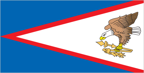
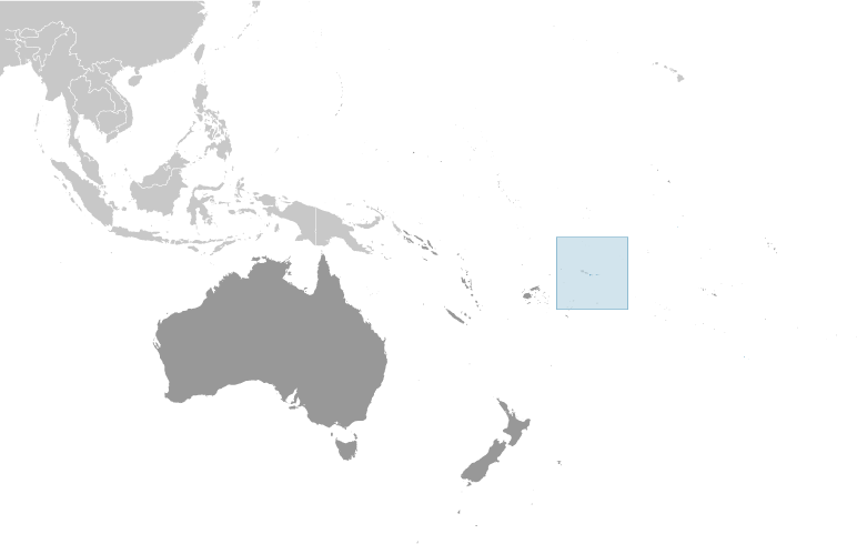


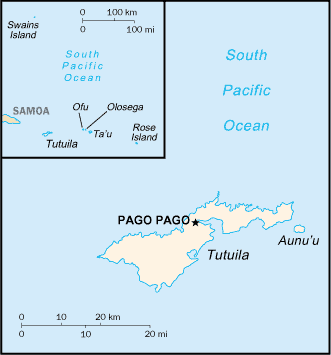
 Image DescriptionThis is the population pyramid for American Samoa. A population pyramid illustrates the age and sex structure of a country's population and may provide insights about political and social stability, as well as economic development. The population is distributed along the horizontal axis, with males shown on the left and females on the right. The male and female populations are broken down into 5-year age groups represented as horizontal bars along the vertical axis, with the youngest age groups at the bottom and the oldest at the top. The shape of the population pyramid gradually evolves over time based on fertility, mortality, and international migration trends.