Location:
This entry identifies the country's regional location, neighboring countries, and adjacent bodies of water.

Southern Africa, group of islands at the northern mouth of the Mozambique Channel, about two-thirds of the way between northern Madagascar and northern Mozambique
Geographic coordinates:
This entry includes rounded latitude and longitude figures for the centroid or center point of a country expressed in degrees and minutes; it is based on the locations provided in the Geographic Names Server (GNS), maintained by the National Geospatial-Intelligence Agency on behalf of the US Board on Geographic Names.
Map references:
This entry includes the name of the Factbook reference map on which a country may be found. Note that boundary representations on these maps are not necessarily authoritative. The entry on Geographic coordinates may be helpful in finding some smaller countries.
Area:
This entry includes three subfields. Total area is the sum of all land and water areas delimited by international boundaries and/or coastlines. Land area is the aggregate of all surfaces delimited by international boundaries and/or coastlines, excluding inland water bodies (lakes, reservoirs, rivers). Water area is the sum of the surfaces of all inland water bodies, such as lakes, reservoirs, or rivers, as delimited by international boundaries and/or coastlines.
total:
2,235 sq km
land:
2,235 sq km
water:
0 sq km
country comparison to the world:
180
Area - comparative:
This entry provides an area comparison based on total area equivalents. Most entities are compared with the entire US or one of the 50 states based on area measurements (1990 revised) provided by the US Bureau of the Census. The smaller entities are compared with Washington, DC (178 sq km, 69 sq mi) or The Mall in Washington, DC (0.59 sq km, 0.23 sq mi, 146 acres).
slightly more than 12 times the size of Washington, DC
Area comparison map:

slightly more than 12 times the size of Washington, DC
Land boundaries:
This entry contains the total length of all land boundaries and the individual lengths for each of the contiguous border countries. When available, official lengths published by national statistical agencies are used. Because surveying methods may differ, country border lengths reported by contiguous countries may differ.
Coastline:
This entry gives the total length of the boundary between the land area (including islands) and the sea.
Maritime claims:
This entry includes the following claims, the definitions of which are excerpted from the United Nations Convention on the Law of the Sea (UNCLOS), which alone contains the full and definitive descriptions: territorial sea - the sovereignty of a coastal state extends beyond its land territory and internal waters to an adjacent belt of sea, described as the territorial sea in the UNCLOS (Part II); this sovereignty extends to the air space over the territorial sea as well as its underlying s . . .
more
territorial sea:
12
nm
exclusive economic zone:
200
nm
Climate:
This entry includes a brief description of typical weather regimes throughout the year; in the Word entry only, it includes four subfields that describe climate extremes:ten driest places on earth (average annual precipitation) describes the annual average precipitation measured in both millimeters and inches for selected countries with climate extremes.
ten wettest places on earth (average annual precipitation) describes the annual average precipitation measured in both millimeters and i . . .
more
tropical marine; rainy season (November to May)
Terrain:
This entry contains a brief description of the topography.
volcanic islands, interiors vary from steep mountains to low hills
Elevation:
This entry includes the mean elevation and elevation extremes, lowest point and highest point.
lowest point:
Indian Ocean 0 m
highest point:
Karthala 2,360 m
Natural resources:
This entry lists a country's mineral, petroleum, hydropower, and other resources of commercial importance, such as rare earth elements (REEs). In general, products appear only if they make a significant contribution to the economy, or are likely to do so in the future.
Land use:
This entry contains the percentage shares of total land area for three different types of land use: agricultural land, forest, and other; agricultural land is further divided into arable land - land cultivated for crops like wheat, maize, and rice that are replanted after each harvest, permanent crops - land cultivated for crops like citrus, coffee, and rubber that are not replanted after each harvest, and includes land under flowering shrubs, fruit trees, nut trees, and vines, and permane . . .
more
agricultural land:
84.4%
(2011 est.)
arable land:
46.7%
(2011 est.)
/
permanent crops:
29.6%
(2011 est.)
/
permanent pasture:
8.1%
(2011 est.)
forest:
1.4%
(2011 est.)
other:
14.2%
(2011 est.)
Irrigated land:
This entry gives the number of square kilometers of land area that is artificially supplied with water.
Population distribution:
This entry provides a summary description of the population dispersion within a country. While it may suggest population density, it does not provide density figures.
the capital city of Maroni, located on the western side of the island of Grande Comore, is the country's largest city; however, of the three islands that comprise Comoros, it is Anjouan that is the most densely populated
Natural hazards:
This entry lists potential natural disasters. For countries where volcanic activity is common, a volcanism subfield highlights historically active volcanoes.
cyclones possible during rainy season (December to April); volcanic activity on Grand Comore
volcanism: Karthala (2,361 m) on Grand Comore Island last erupted in 2007; a 2005 eruption forced thousands of people to be evacuated and produced a large ash cloud
Environment - current issues:
This entry lists the most pressing and important environmental problems. The following terms and abbreviations are used throughout the entry:
Acidification - the lowering of soil and water pH due to acid precipitation and deposition usually through precipitation; this process disrupts ecosystem nutrient flows and may kill freshwater fish and plants dependent on more neutral or alkaline conditions (see acid rain).
Acid rain - characterized as containing harmful levels of sulfur dioxi . . .
more
deforestation; soil degradation and erosion results from forest loss and from crop cultivation on slopes without proper terracing; marine biodiversity affected as soil erosion leads to the silting of coral reefs
Environment - international agreements:
This entry separates country participation in international environmental agreements into two levels - party to and signed, but not ratified. Agreements are listed in alphabetical order by the abbreviated form of the full name.
party to:
Biodiversity, Climate Change, Climate Change-Kyoto Protocol, Desertification, Endangered Species, Hazardous Wastes, Law of the Sea, Ozone Layer Protection, Ship Pollution, Wetlands
signed, but not ratified:
none of the selected agreements
Geography - note:
This entry includes miscellaneous geographic information of significance not included elsewhere.
important location at northern end of Mozambique Channel
Population:
This entry gives an estimate from the US Bureau of the Census based on statistics from population censuses, vital statistics registration systems, or sample surveys pertaining to the recent past and on assumptions about future trends. The total population presents one overall measure of the potential impact of the country on the world and within its region. Note: Starting with the 1993 Factbook, demographic estimates for some countries (mostly African) have explicitly taken into account t . . .
more
821,164
(July 2018 est.)
country comparison to the world:
163
Nationality:
This entry provides the identifying terms for citizens - noun and adjective.
noun:
Comoran(s)
adjective:
Comoran
Ethnic groups:
This entry provides an ordered listing of ethnic groups starting with the largest and normally includes the percent of total population.
Antalote, Cafre, Makoa, Oimatsaha, Sakalava
Languages:
This entry provides a listing of languages spoken in each country and specifies any that are official national or regional languages. When data is available, the languages spoken in each country are broken down according to the percent of the total population speaking each language as a first language. For those countries without available data, languages are listed in rank order based on prevalence, starting with the most-spoken language.
Arabic (official), French (official), Shikomoro (official; a blend of Swahili and Arabic) (Comorian)
Religions:
This entry is an ordered listing of religions by adherents starting with the largest group and sometimes includes the percent of total population. The core characteristics and beliefs of the world's major religions are described below. Baha'i - Founded by Mirza Husayn-Ali (known as Baha'u'llah) in Iran in 1852, Baha'i faith emphasizes monotheism and believes in one eternal transcendent God. Its guiding focus is to encourage the unity of all peoples on the earth so that justice and peace m . . .
more
Sunni Muslim 98%, other (including Shia Muslim, Roman Catholic, Jehovah's Witness, Protestant) 2%
note: Sunni Islam is the state religion
Demographic profile:
This entry describes a country’s key demographic features and trends and how they vary among regional, ethnic, and socioeconomic sub-populations. Some of the topics addressed are population age structure, fertility, health, mortality, poverty, education, and migration.
Comoros’ population is a melange of Arabs, Persians, Indonesians, Africans, and Indians, and the much smaller number of Europeans that settled on the islands between the 8th and 19th centuries, when they served as a regional trade hub. The Arab and Persian influence is most evident in the islands’ overwhelmingly Muslim majority – about 98% of Comorans are Sunni Muslims. The country is densely populated, averaging nearly 350 people per square mile, although this varies widely among the islands, with Anjouan being the most densely populated.
Given the large share of land dedicated to agriculture and Comoros’ growing population, habitable land is becoming increasingly crowded. The combination of increasing population pressure on limited land and resources, widespread poverty, and poor job prospects motivates thousands of Comorans each year to attempt to illegally migrate using small fishing boats to the neighboring island of Mayotte, which is a French territory. The majority of legal Comoran migration to France came after Comoros’ independence from France in 1975, with the flow peaking in the mid-1980s.
At least 150,000 to 200,000 people of Comoran citizenship or descent live abroad, mainly in France, where they have gone seeking a better quality of life, job opportunities, higher education (Comoros has no universities), advanced health care, and to finance elaborate traditional wedding ceremonies (aada). Remittances from the diaspora are an economic mainstay, in 2013 representing approximately 25% of Comoros’ GDP and significantly more than the value of its exports of goods and services (only 15% of GDP). Grand Comore, Comoros’ most populous island, is both the primary source of emigrants and the main recipient of remittances. Most remittances are spent on private consumption, but this often goes toward luxury goods and the aada and does not contribute to economic development or poverty reduction. Although the majority of the diaspora is now French-born with more distant ties to Comoros, it is unclear whether they will sustain the current level of remittances.
Age structure:
This entry provides the distribution of the population according to age. Information is included by sex and age group as follows: 0-14 years (children), 15-24 years (early working age), 25-54 years (prime working age), 55-64 years (mature working age), 65 years and over (elderly). The age structure of a population affects a nation's key socioeconomic issues. Countries with young populations (high percentage under age 15) need to invest more in schools, while countries with older population . . .
more
0-14 years:
38.54%
(male 157,764 /female 158,676)
15-24 years:
19.89%
(male 79,133 /female 84,181)
25-54 years:
33.25%
(male 129,645 /female 143,408)
55-64 years:
4.34%
(male 15,957 /female 19,690)
65 years and over:
3.98%
(male 14,881 /female 17,829)
(2018 est.)
population pyramid:

This is the population pyramid for Comoros. A population pyramid illustrates the age and sex structure of a country's population and may provide insights about political and social stability, as well as economic development. The population is distributed along the horizontal axis, with males shown on the left and females on the right. The male and female populations are broken down into 5-year age groups represented as horizontal bars along the vertical axis, with the youngest age groups at the bottom and the oldest at the top. The shape of the population pyramid gradually evolves over time based on fertility, mortality, and international migration trends.
For additional information, please see the entry for Population pyramid on the Definitions and Notes page under the References tab.
Dependency ratios:
Dependency ratios are a measure of the age structure of a population. They relate the number of individuals that are likely to be economically "dependent" on the support of others. Dependency ratios contrast the ratio of youths (ages 0-14) and the elderly (ages 65+) to the number of those in the working-age group (ages 15-64). Changes in the dependency ratio provide an indication of potential social support requirements resulting from changes in population age structures. As fertility leve . . .
more
total dependency ratio:
75.5
(2015 est.)
youth dependency ratio:
70.5
(2015 est.)
elderly dependency ratio:
5.1
(2015 est.)
potential support ratio:
19.7
(2015 est.)
Population growth rate:
The average annual percent change in the population, resulting from a surplus (or deficit) of births over deaths and the balance of migrants entering and leaving a country. The rate may be positive or negative. The growth rate is a factor in determining how great a burden would be imposed on a country by the changing needs of its people for infrastructure (e.g., schools, hospitals, housing, roads), resources (e.g., food, water, electricity), and jobs. Rapid population growth can be seen as . . .
more
1.57%
(2018 est.)
country comparison to the world:
66
Birth rate:
This entry gives the average annual number of births during a year per 1,000 persons in the population at midyear; also known as crude birth rate. The birth rate is usually the dominant factor in determining the rate of population growth. It depends on both the level of fertility and the age structure of the population.
25.3 births/1,000 population
(2018 est.)
country comparison to the world:
49
Death rate:
This entry gives the average annual number of deaths during a year per 1,000 population at midyear; also known as crude death rate. The death rate, while only a rough indicator of the mortality situation in a country, accurately indicates the current mortality impact on population growth. This indicator is significantly affected by age distribution, and most countries will eventually show a rise in the overall death rate, in spite of continued decline in mortality at all ages, as declining . . .
more
7.1 deaths/1,000 population
(2018 est.)
country comparison to the world:
125
Net migration rate:
This entry includes the figure for the difference between the number of persons entering and leaving a country during the year per 1,000 persons (based on midyear population). An excess of persons entering the country is referred to as net immigration (e.g., 3.56 migrants/1,000 population); an excess of persons leaving the country as net emigration (e.g., -9.26 migrants/1,000 population). The net migration rate indicates the contribution of migration to the overall level of population chan . . .
more
-2.4 migrant(s)/1,000 population
(2018 est.)
country comparison to the world:
167
Population distribution:
This entry provides a summary description of the population dispersion within a country. While it may suggest population density, it does not provide density figures.
the capital city of Maroni, located on the western side of the island of Grande Comore, is the country's largest city; however, of the three islands that comprise Comoros, it is Anjouan that is the most densely populated
Urbanization:
This entry provides two measures of the degree of urbanization of a population. The first, urban population, describes the percentage of the total population living in urban areas, as defined by the country. The second, rate of urbanization, describes the projected average rate of change of the size of the urban population over the given period of time. It is possible for a country with a 100% urban population to still display a change in the rate of urbanization (up or down). For example . . .
more
urban population:
29.2% of total population
(2019)
rate of urbanization:
2.87% annual rate of change
(2015-20 est.)
Major urban areas - population:
This entry provides the population of the capital and up to six major cities defined as urban agglomerations with populations of at least 750,000 people. An urban agglomeration is defined as comprising the city or town proper and also the suburban fringe or thickly settled territory lying outside of, but adjacent to, the boundaries of the city. For smaller countries, lacking urban centers of 750,000 or more, only the population of the capital is presented.
62,000 MORONI (capital)
(2018)
Sex ratio:
This entry includes the number of males for each female in five age groups - at birth, under 15 years, 15-64 years, 65 years and over, and for the total population. Sex ratio at birth has recently emerged as an indicator of certain kinds of sex discrimination in some countries. For instance, high sex ratios at birth in some Asian countries are now attributed to sex-selective abortion and infanticide due to a strong preference for sons. This will affect future marriage patterns and fertilit . . .
more
at birth:
1.03 male(s)/female
0-14 years:
0.99 male(s)/female
15-24 years:
0.94 male(s)/female
25-54 years:
0.9 male(s)/female
55-64 years:
0.81 male(s)/female
65 years and over:
0.83 male(s)/female
total population:
0.94 male(s)/female
(2018 est.)
Mother's mean age at first birth:
This entry provides the mean (average) age of mothers at the birth of their first child. It is a useful indicator for gauging the success of family planning programs aiming to reduce maternal mortality, increase contraceptive use – particularly among married and unmarried adolescents – delay age at first marriage, and improve the health of newborns.
24.6 years
(2012 est.)
note: median age at first birth among women 25-29
Maternal mortality rate:
The maternal mortality rate (MMR) is the annual number of female deaths per 100,000 live births from any cause related to or aggravated by pregnancy or its management (excluding accidental or incidental causes). The MMR includes deaths during pregnancy, childbirth, or within 42 days of termination of pregnancy, irrespective of the duration and site of the pregnancy, for a specified year.
273 deaths/100,000 live births
(2017 est.)
country comparison to the world:
40
Infant mortality rate:
This entry gives the number of deaths of infants under one year old in a given year per 1,000 live births in the same year. This rate is often used as an indicator of the level of health in a country.
total:
58.3 deaths/1,000 live births
(2018 est.)
male:
68.4 deaths/1,000 live births
female:
47.9 deaths/1,000 live births
country comparison to the world:
17
Life expectancy at birth:
This entry contains the average number of years to be lived by a group of people born in the same year, if mortality at each age remains constant in the future. Life expectancy at birth is also a measure of overall quality of life in a country and summarizes the mortality at all ages. It can also be thought of as indicating the potential return on investment in human capital and is necessary for the calculation of various actuarial measures.
total population:
64.9 years
(2018 est.)
male:
62.6 years
female:
67.4 years
country comparison to the world:
185
Total fertility rate:
This entry gives a figure for the average number of children that would be born per woman if all women lived to the end of their childbearing years and bore children according to a given fertility rate at each age. The total fertility rate (TFR) is a more direct measure of the level of fertility than the crude birth rate, since it refers to births per woman. This indicator shows the potential for population change in the country. A rate of two children per woman is considered the replaceme . . .
more
3.21 children born/woman
(2018 est.)
country comparison to the world:
46
Contraceptive prevalence rate:
This field gives the percent of women of reproductive age (15-49) who are married or in union and are using, or whose sexual partner is using, a method of contraception according to the date of the most recent available data. The contraceptive prevalence rate is an indicator of health services, development, and women’s empowerment. It is also useful in understanding, past, present, and future fertility trends, especially in developing countries.
Drinking water source:
This entry provides information about access to improved or unimproved drinking water sources available to segments of the population of a country. Improved drinking water - use of any of the following sources: piped water into dwelling, yard, or plot; public tap or standpipe; tubewell or borehole; protected dug well; protected spring; or rainwater collection. Unimproved drinking water - use of any of the following sources: unprotected dug well; unprotected spring; cart with small tank or . . .
more
improved:
urban:
92.6% of population
rural:
89.1% of population
total:
90.1% of population
unimproved:
urban:
7.4% of population
rural:
10.9% of population
total:
9.9% of population
(2015 est.)
Current Health Expenditure:
Current Health Expenditure (CHE) describes the share of spending on health in each country relative to the size of its economy. It includes expenditures corresponding to the final consumption of health care goods and services and excludes investment, exports, and intermediate consumption. CHE shows the importance of the health sector in the economy and indicates the priority given to health in monetary terms. Note: Current Health Expenditure replaces the former Health Expenditures field . . .
more
Physicians density:
This entry gives the number of medical doctors (physicians), including generalist and specialist medical practitioners, per 1,000 of the population. Medical doctors are defined as doctors that study, diagnose, treat, and prevent illness, disease, injury, and other physical and mental impairments in humans through the application of modern medicine. They also plan, supervise, and evaluate care and treatment plans by other health care providers. The World Health Organization estimates that f . . .
more
0.17 physicians/1,000 population
(2012)
Hospital bed density:
This entry provides the number of hospital beds per 1,000 people; it serves as a general measure of inpatient service availability. Hospital beds include inpatient beds available in public, private, general, and specialized hospitals and rehabilitation centers. In most cases, beds for both acute and chronic care are included. Because the level of inpatient services required for individual countries depends on several factors - such as demographic issues and the burden of disease - there is . . .
more
2.2 beds/1,000 population
(2010)
Sanitation facility access:
This entry provides information about access to improved or unimproved sanitation facilities available to segments of the population of a country. Improved sanitation - use of any of the following facilities: flush or pour-flush to a piped sewer system, septic tank or pit latrine; ventilated improved pit (VIP) latrine; pit latrine with slab; or a composting toilet. Unimproved sanitation - use of any of the following facilities: flush or pour-flush not piped to a sewer system, septic tank . . .
more
improved:
urban:
48.3% of population
(2015 est.)
rural:
30.9% of population
(2015 est.)
total:
35.8% of population
(2015 est.)
unimproved:
urban:
51.7% of population
(2015 est.)
rural:
69.1% of population
(2015 est.)
total:
64.2% of population
(2015 est.)
HIV/AIDS - adult prevalence rate:
This entry gives an estimate of the percentage of adults (aged 15-49) living with HIV/AIDS. The adult prevalence rate is calculated by dividing the estimated number of adults living with HIV/AIDS at yearend by the total adult population at yearend.
HIV/AIDS - people living with HIV/AIDS:
This entry gives an estimate of all people (adults and children) alive at yearend with HIV infection, whether or not they have developed symptoms of AIDS.
HIV/AIDS - deaths:
This entry gives an estimate of the number of adults and children who died of AIDS during a given calendar year.
Obesity - adult prevalence rate:
This entry gives the percent of a country's population considered to be obese. Obesity is defined as an adult having a Body Mass Index (BMI) greater to or equal to 30.0. BMI is calculated by taking a person's weight in kg and dividing it by the person's squared height in meters.
7.8%
(2016)
country comparison to the world:
157
Children under the age of 5 years underweight:
This entry gives the percent of children under five considered to be underweight. Underweight means weight-for-age is approximately 2 kg below for standard at age one, 3 kg below standard for ages two and three, and 4 kg below standard for ages four and five. This statistic is an indicator of the nutritional status of a community. Children who suffer from growth retardation as a result of poor diets and/or recurrent infections tend to have a greater risk of suffering illness and death.
16.9%
(2012)
country comparison to the world:
35
2.5% of GDP
(2015)
country comparison to the world:
160
Literacy:
This entry includes a definition of literacy and UNESCO's percentage estimates for populations aged 15 years and over, including total population, males, and females. There are no universal definitions and standards of literacy. Unless otherwise specified, all rates are based on the most common definition - the ability to read and write at a specified age. Detailing the standards that individual countries use to assess the ability to read and write is beyond the scope of the Factbook. Info . . .
more
definition:
age 15 and over can read and write
total population:
77.8%
male:
81.8%
female:
73.7%
(2015)
School life expectancy (primary to tertiary education):
School life expectancy (SLE) is the total number of years of schooling (primary to tertiary) that a child can expect to receive, assuming that the probability of his or her being enrolled in school at any particular future age is equal to the current enrollment ratio at that age.
Caution must be maintained when utilizing this indicator in international comparisons. For example, a year or grade completed in one country is not necessarily the same in terms of educational content or qualit . . .
more
total:
11 years
male:
11 years
female:
11 years
(2014)
Country name:
This entry includes all forms of the country's name approved by the US Board on Geographic Names (Italy is used as an example): conventional long form (Italian Republic), conventional short form (Italy), local long form (Repubblica Italiana), local short form (Italia), former (Kingdom of Italy), as well as the abbreviation. Also see the Terminology note.
conventional long form:
Union of the Comoros
conventional short form:
Comoros
local long form:
Udzima wa Komori (Comorian), Union des Comores (French), Jumhuriyat al Qamar al Muttahidah (Arabic)
local short form:
Komori (Comorian), Comores (French), Juzur al Qamar (Arabic)
etymology:
name derives from the Arabic designation "Juzur al Qamar" meaning "Islands of the Moon"
Government type:
This entry gives the basic form of government. Definitions of the major governmental terms are as follows. (Note that for some countries more than one definition applies.):
Absolute monarchy - a form of government where the monarch rules unhindered, i.e., without any laws, constitution, or legally organized opposition.
Anarchy - a condition of lawlessness or political disorder brought about by the absence of governmental authority.
Authoritarian - a form of government in whic . . .
more
federal presidential republic
Capital:
This entry gives the name of the seat of government, its geographic coordinates, the time difference relative to Coordinated Universal Time (UTC) and the time observed in Washington, DC, and, if applicable, information on daylight saving time (DST). Where appropriate, a special note has been added to highlight those countries that have multiple time zones.
name:
Moroni
geographic coordinates:
11 42 S, 43 14 E
time difference:
UTC+3 (8 hours ahead of Washington, DC, during Standard Time)
etymology: Moroni derives from "mroni," which means "at the river" in Shingazidja, the Comorian language spoken on Grande Comore (N'gazidja)
Administrative divisions:
This entry generally gives the numbers, designatory terms, and first-order administrative divisions as approved by the US Board on Geographic Names (BGN). Changes that have been reported but not yet acted on by the BGN are noted. Geographic names conform to spellings approved by the BGN with the exception of the omission of diacritical marks and special characters.
3 islands; Anjouan (Ndzuwani), Grande Comore (N'gazidja), Moheli (Mwali)
Independence:
For most countries, this entry gives the date that sovereignty was achieved and from which nation, empire, or trusteeship. For the other countries, the date given may not represent "independence" in the strict sense, but rather some significant nationhood event such as the traditional founding date or the date of unification, federation, confederation, establishment, fundamental change in the form of government, or state succession. For a number of countries, the establishment of statehood . . .
more
6 July 1975 (from France)
National holiday:
This entry gives the primary national day of celebration - usually independence day.
Independence Day, 6 July (1975)
Constitution:
This entry provides information on a country’s constitution and includes two subfields. The history subfield includes the dates of previous constitutions and the main steps and dates in formulating and implementing the latest constitution. For countries with 1-3 previous constitutions, the years are listed; for those with 4-9 previous, the entry is listed as “several previous,” and for those with 10 or more, the entry is “many previous.” The amendments subfield summarizes the process of am . . .
more
history:
previous 1996, 2001; newest adopted 30 July 2018
amendments:
proposed by the president of the union or supported by at least one third of the Assembly of the Union membership; adoption requires approval by at three-quarters majority of the total Assembly membership or approval in a referendum
(2019)
note: a referendum held on 30 July 2018 - boycotted by the opposition - overwhelmingly approved a new constitution that allows for 2 consecutive 5-year presidential terms and revises the rotating presidency within the islands
Legal system:
This entry provides the description of a country's legal system. A statement on judicial review of legislative acts is also included for a number of countries. The legal systems of nearly all countries are generally modeled upon elements of five main types: civil law (including French law, the Napoleonic Code, Roman law, Roman-Dutch law, and Spanish law); common law (including United State law); customary law; mixed or pluralistic law; and religious law (including Islamic law). An addition . . .
more
mixed legal system of Islamic religious law, the French civil code of 1975, and customary law
International law organization participation:
This entry includes information on a country's acceptance of jurisdiction of the International Court of Justice (ICJ) and of the International Criminal Court (ICCt); 59 countries have accepted ICJ jurisdiction with reservations and 11 have accepted ICJ jurisdiction without reservations; 122 countries have accepted ICCt jurisdiction. Appendix B: International Organizations and Groups explains the differing mandates of the ICJ and ICCt.
has not submitted an ICJ jurisdiction declaration; accepts ICCt jurisdiction
Citizenship:
This entry provides information related to the acquisition and exercise of citizenship; it includes four subfields: citizenship by birth describes the acquisition of citizenship based on place of birth, known as Jus soli, regardless of the citizenship of parents. citizenship by descent only describes the acquisition of citizenship based on the principle of Jus sanguinis, or by descent, where at least one parent is a citizen of the state and being born within the territorial limits of the s . . .
more
citizenship by birth:
no
citizenship by descent only:
at least one parent must be a citizen of the Comoros
dual citizenship recognized:
no
residency requirement for naturalization:
10 years
Suffrage:
This entry gives the age at enfranchisement and whether the right to vote is universal or restricted.
18 years of age; universal
Executive branch:
This entry includes five subentries: chief of state; head of government; cabinet; elections/appointments; election results. Chief of state includes the name, title, and beginning date in office of the titular leader of the country who represents the state at official and ceremonial functions but may not be involved with the day-to-day activities of the government. Head of government includes the name, title of the top executive designated to manage the executive branch of the government, a . . .
more
chief of state:
President AZALI Assoumani (since 26 May 2016); note - the president is both chief of state and head of government; note - AZALI takes oath of office 2 June 2019 after 24 March 2019 reelection
(2019)
head of government:
President AZALI Assoumani (since 26 May 2016)
cabinet:
Council of Ministers appointed by the president
elections/appointments:
president directly elected by simple majority popular vote in 2 rounds for a 5-year term (eligible for a second term); election last held on 24 March 2019 (next to be held in 2024)
election results:
AZALI Assoumani (CRC) elected president in first round; with a 59% of the vote; - AZALI Assoumani (CRC) 60.8%, Ahamada MAHAMOUDOU (PJ) 14.6%, and Mouigni Baraka Said SOILIHI (independent) 5.6%
Legislative branch:
This entry has three subfields. The description subfield provides the legislative structure (unicameral – single house; bicameral – an upper and a lower house); formal name(s); number of member seats; types of constituencies or voting districts (single seat, multi-seat, nationwide); electoral voting system(s); and member term of office. The elections subfield includes the dates of the last election and next election. The election results subfield lists percent of vote by party/coalition an . . .
more
description:
unicameral Assembly of the Union (33 seats; 24 members directly elected by absolute majority vote in 2 rounds if needed and 9 members indirectly elected by the 3 island assemblies; members serve 5-year terms)
(2017)
elections:
last held on 25 January 2015 with a runoff on 22 February 2015 (next to be held in 2020)
(2017)
election results:
percent of vote by party - UPDC 29.1%, PJ 20.5%, RDC 21.3%, other 29.1%; seats by party - UPDC 8, PJ 7, RDC 2, CRC 2, RADHI 1, PEC 1, independent 3; composition - men 32, women 1, percent of women 3%; note - 9 additional seats filled by the 3 island assemblies
Judicial branch:
This entry includes three subfields. The highest court(s) subfield includes the name(s) of a country's highest level court(s), the number and titles of the judges, and the types of cases heard by the court, which commonly are based on civil, criminal, administrative, and constitutional law. A number of countries have separate constitutional courts. The judge selection and term of office subfield includes the organizations and associated officials responsible for nominating and appointing j . . .
more
highest courts:
Supreme Court or Cour Supreme (consists of 7 judges)
judge selection and term of office:
Supreme Court judges - selection and term of office NA
subordinate courts:
Court of Appeals (in Moroni); Tribunal de premiere instance; island village (community) courts; religious courts
Political parties and leaders:
This entry includes a listing of significant political parties, coalitions, and electoral lists as of each country's last legislative election, unless otherwise noted.
Convention for the Renewal of the Comoros or CRC [AZALI Assoumani]
Democratic Rally of the Comoros or RDC [Mouigni BARAKA]
Juwa Party or PJ [Ahmed Abdallah SAMBI, Mahamoudou AHAMADA]
Party for the Comorian Agreement (Partie Pour l'Entente Commorienne) or PEC [Fahmi Said IBRAHIM]
Rally for an Alternative of Harmonious and Integrated Development or RADHI [Abdou SOEFO]
Rally with a Development Initiative for Enlightened Youth or RIDJA [Said LARIFOU]
Union for the Development of the Comoros or UPDC [Mohamed HALIFA]
(2018)
International organization participation:
This entry lists in alphabetical order by abbreviation those international organizations in which the subject country is a member or participates in some other way.
ACP, AfDB, AMF, AOSIS, AU, CAEU (candidates), COMESA, FAO, FZ, G-77, IBRD, ICAO, ICCt, ICRM, IDA, IDB, IFAD, IFC, IFRCS, ILO, IMF, IMO, IMSO, InOC, Interpol, IOC, IOM, ITSO, ITU, ITUC (NGOs), LAS, MIGA, NAM, OIC, OIF, OPCW, UN, UNCTAD, UNESCO, UNIDO, UPU, WCO, WHO, WIPO, WMO, WTO (observer)
Diplomatic representation in the US:
This entry includes the chief of mission, chancery address, telephone, FAX, consulate general locations, and consulate locations. The use of the annotated title Appointed Ambassador refers to a new ambassador who has presented his/her credentials to the secretary of state but not the US president. Such ambassadors fulfill all diplomatic functions except meeting with or appearing at functions attended by the president until such time as they formally present their credentials at a White Hou . . .
more
vacant
chancery:
Mission to the US, 866 United Nations Plaza, Suite 418, New York, NY 10017
telephone:
[1] (212) 750-1637
FAX:
[1] (212) 750-1657
Diplomatic representation from the US:
This entry includes the chief of mission, embassy address, mailing address, telephone number, FAX number, branch office locations, consulate general locations, and consulate locations.
the US does not have an embassy in Comoros; the US Ambassador to Madagascar is accredited to Comoros
Flag description:
This entry provides a written flag description produced from actual flags or the best information available at the time the entry was written. The flags of independent states are used by their dependencies unless there is an officially recognized local flag. Some disputed and other areas do not have flags.
four equal horizontal bands of yellow (top), white, red, and blue, with a green isosceles triangle based on the hoist; centered within the triangle is a vertical white crescent moon with the convex side facing the hoist and four white, five-pointed stars placed vertically in a line between the points of the crescent; the horizontal bands and the four stars represent the four main islands of the archipelago - Mwali, N'gazidja, Ndzuwani, and Mahore (Mayotte - department of France, but claimed by Comoros)
note: the crescent, stars, and color green are traditional symbols of Islam
National symbol(s):
A national symbol is a faunal, floral, or other abstract representation - or some distinctive object - that over time has come to be closely identified with a country or entity. Not all countries have national symbols; a few countries have more than one.
four five-pointed stars and crescent moon; national colors: green, white
National anthem:
A generally patriotic musical composition - usually in the form of a song or hymn of praise - that evokes and eulogizes the history, traditions, or struggles of a nation or its people. National anthems can be officially recognized as a national song by a country's constitution or by an enacted law, or simply by tradition. Although most anthems contain lyrics, some do not.
name:
"Udzima wa ya Masiwa" (The Union of the Great Islands)
lyrics/music:
Said Hachim SIDI ABDEREMANE/Said Hachim SIDI ABDEREMANE and Kamildine ABDALLAH
Economy - overview:
This entry briefly describes the type of economy, including the degree of market orientation, the level of economic development, the most important natural resources, and the unique areas of specialization. It also characterizes major economic events and policy changes in the most recent 12 months and may include a statement about one or two key future macroeconomic trends.
One of the world's poorest and smallest economies, the Comoros is made up of three islands that are hampered by inadequate transportation links, a young and rapidly increasing population, and few natural resources. The low educational level of the labor force contributes to a subsistence level of economic activity and a heavy dependence on foreign grants and technical assistance. Agriculture, including fishing, hunting, and forestry, accounts for about 50% of GDP, employs a majority of the labor force, and provides most of the exports. Export income is heavily reliant on the three main crops of vanilla, cloves, and ylang ylang (perfume essence); and the Comoros' export earnings are easily disrupted by disasters such as fires and extreme weather. Despite agriculture’s importance to the economy, the country imports roughly 70% of its food; rice, the main staple, and other dried vegetables account for more than 25% of imports. Remittances from about 300,000 Comorans contribute about 25% of the country’s GDP. France, Comoros’s colonial power, remains a key trading partner and bilateral donor.
Comoros faces an education system in need of upgrades, limited opportunities for private commercial and industrial enterprises, poor health services, limited exports, and a high population growth rate. Recurring political instability, sometimes initiated from outside the country, and an ongoing electricity crisis have inhibited growth. The government, elected in mid-2016, has moved to improve revenue mobilization, reduce expenditures, and improve electricity access, although the public sector wage bill remains one of the highest in sub-Saharan Africa. In mid-2017, Comoros joined the Southern African Development Community with 15 other regional member states.
GDP (purchasing power parity):
This entry gives the gross domestic product (GDP) or value of all final goods and services produced within a nation in a given year. A nation's GDP at purchasing power parity (PPP) exchange rates is the sum value of all goods and services produced in the country valued at prices prevailing in the United States in the year noted. This is the measure most economists prefer when looking at per-capita welfare and when comparing living conditions or use of resources across countries. The measur . . .
more
$1.319 billion
(2017 est.)
$1.284 billion
(2016 est.)
$1.257 billion
(2015 est.)
note: data are in 2017 dollars
country comparison to the world:
201
GDP (official exchange rate):
This entry gives the gross domestic product (GDP) or value of all final goods and services produced within a nation in a given year. A nation's GDP at official exchange rates (OER) is the home-currency-denominated annual GDP figure divided by the bilateral average US exchange rate with that country in that year. The measure is simple to compute and gives a precise measure of the value of output. Many economists prefer this measure when gauging the economic power an economy maintains vis- . . .
more
GDP - real growth rate:
This entry gives GDP growth on an annual basis adjusted for inflation and expressed as a percent. The growth rates are year-over-year, and not compounded.
2.7%
(2017 est.)
2.2%
(2016 est.)
1%
(2015 est.)
country comparison to the world:
125
GDP - per capita (PPP):
This entry shows GDP on a purchasing power parity basis divided by population as of 1 July for the same year.
$1,600
(2017 est.)
$1,600
(2016 est.)
$1,600
(2015 est.)
note: data are in 2017 dollars
country comparison to the world:
216
Gross national saving:
Gross national saving is derived by deducting final consumption expenditure (household plus government) from Gross national disposable income, and consists of personal saving, plus business saving (the sum of the capital consumption allowance and retained business profits), plus government saving (the excess of tax revenues over expenditures), but excludes foreign saving (the excess of imports of goods and services over exports). The figures are presented as a percent of GDP. A negative . . .
more
17.3% of GDP
(2017 est.)
13.6% of GDP
(2016 est.)
18% of GDP
(2015 est.)
country comparison to the world:
117
GDP - composition, by end use:
This entry shows who does the spending in an economy: consumers, businesses, government, and foreigners. The distribution gives the percentage contribution to total GDP of household consumption, government consumption, investment in fixed capital, investment in inventories, exports of goods and services, and imports of goods and services, and will total 100 percent of GDP if the data are complete. household consumption consists of expenditures by resident households, and by nonprofit insti . . .
more
household consumption:
92.6%
(2017 est.)
government consumption:
20.4%
(2017 est.)
investment in fixed capital:
20%
(2017 est.)
investment in inventories:
-3.1%
(2017 est.)
exports of goods and services:
17.2%
(2017 est.)
imports of goods and services:
-47.1%
(2017 est.)
GDP - composition, by sector of origin:
This entry shows where production takes place in an economy. The distribution gives the percentage contribution of agriculture, industry, and services to total GDP, and will total 100 percent of GDP if the data are complete. Agriculture includes farming, fishing, and forestry. Industry includes mining, manufacturing, energy production, and construction. Services cover government activities, communications, transportation, finance, and all other private economic activities that do not prod . . .
more
agriculture:
47.7%
(2017 est.)
industry:
11.8%
(2017 est.)
services:
40.5%
(2017 est.)
Agriculture - products:
This entry is an ordered listing of major crops and products starting with the most important.
vanilla, cloves, ylang-ylang (perfume essence), coconuts, bananas, cassava (manioc)
Industries:
This entry provides a rank ordering of industries starting with the largest by value of annual output.
fishing, tourism, perfume distillation
1%
(2017 est.)
country comparison to the world:
154
Labor force:
This entry contains the total labor force figure.
278,500
(2016 est.)
country comparison to the world:
166
Labor force - by occupation:
This entry lists the percentage distribution of the labor force by sector of occupation. Agriculture includes farming, fishing, and forestry. Industry includes mining, manufacturing, energy production, and construction. Services cover government activities, communications, transportation, finance, and all other economic activities that do not produce material goods. The distribution will total less than 100 percent if the data are incomplete and may range from 99-101 percent due to rounding.
more
agriculture:
80%
industry:
20%
(1996 est.)
industry and services:
20%
(1996 est.)
Unemployment rate:
This entry contains the percent of the labor force that is without jobs. Substantial underemployment might be noted.
6.5%
(2014 est.)
country comparison to the world:
96
Population below poverty line:
National estimates of the percentage of the population falling below the poverty line are based on surveys of sub-groups, with the results weighted by the number of people in each group. Definitions of poverty vary considerably among nations. For example, rich nations generally employ more generous standards of poverty than poor nations.
Household income or consumption by percentage share:
Data on household income or consumption come from household surveys, the results adjusted for household size. Nations use different standards and procedures in collecting and adjusting the data. Surveys based on income will normally show a more unequal distribution than surveys based on consumption. The quality of surveys is improving with time, yet caution is still necessary in making inter-country comparisons.
lowest 10%:
0.9%
highest 10%:
55.2%
(2004)
Distribution of family income - Gini index:
This index measures the degree of inequality in the distribution of family income in a country. The index is calculated from the Lorenz curve, in which cumulative family income is plotted against the number of families arranged from the poorest to the richest. The index is the ratio of (a) the area between a country's Lorenz curve and the 45 degree helping line to (b) the entire triangular area under the 45 degree line. The more nearly equal a country's income distribution, the closer its . . .
more
55.9
(2004 est.)
country comparison to the world:
8
Budget:
This entry includes revenues, expenditures, and capital expenditures. These figures are calculated on an exchange rate basis, i.e., not in purchasing power parity (PPP) terms.
revenues:
165.2 million
(2017 est.)
expenditures:
207.3 million
(2017 est.)
Taxes and other revenues:
This entry records total taxes and other revenues received by the national government during the time period indicated, expressed as a percent of GDP. Taxes include personal and corporate income taxes, value added taxes, excise taxes, and tariffs. Other revenues include social contributions - such as payments for social security and hospital insurance - grants, and net revenues from public enterprises. Normalizing the data, by dividing total revenues by GDP, enables easy comparisons acr . . .
more
25.3% (of GDP)
(2017 est.)
country comparison to the world:
117
Budget surplus (+) or deficit (-):
This entry records the difference between national government revenues and expenditures, expressed as a percent of GDP. A positive (+) number indicates that revenues exceeded expenditures (a budget surplus), while a negative (-) number indicates the reverse (a budget deficit). Normalizing the data, by dividing the budget balance by GDP, enables easy comparisons across countries and indicates whether a national government saves or borrows money. Countries with high budget deficits (relat . . .
more
-6.5% (of GDP)
(2017 est.)
country comparison to the world:
188
Public debt:
This entry records the cumulative total of all government borrowings less repayments that are denominated in a country's home currency. Public debt should not be confused with external debt, which reflects the foreign currency liabilities of both the private and public sector and must be financed out of foreign exchange earnings.
32.4% of GDP
(2017 est.)
27.7% of GDP
(2016 est.)
country comparison to the world:
160
Fiscal year:
This entry identifies the beginning and ending months for a country's accounting period of 12 months, which often is the calendar year but which may begin in any month. All yearly references are for the calendar year (CY) unless indicated as a noncalendar fiscal year (FY).
1%
(2017 est.)
1.8%
(2016 est.)
country comparison to the world:
50
Central bank discount rate:
This entry provides the annualized interest rate a country's central bank charges commercial, depository banks for loans to meet temporary shortages of funds.
1.93%
(31 December 2010)
2.21%
(31 December 2009)
country comparison to the world:
120
Commercial bank prime lending rate:
This entry provides a simple average of annualized interest rates commercial banks charge on new loans, denominated in the national currency, to their most credit-worthy customers.
10.5%
(31 December 2017 est.)
10.5%
(31 December 2016 est.)
country comparison to the world:
81
Stock of narrow money:
This entry, also known as "M1," comprises the total quantity of currency in circulation (notes and coins) plus demand deposits denominated in the national currency held by nonbank financial institutions, state and local governments, nonfinancial public enterprises, and the private sector of the economy, measured at a specific point in time. National currency units have been converted to US dollars at the closing exchange rate for the date of the information. Because of exchange rate moveme . . .
more
$200.8 million
(31 December 2017 est.)
$180.5 million
(31 December 2016 est.)
country comparison to the world:
183
Stock of broad money:
This entry covers all of "Narrow money," plus the total quantity of time and savings deposits, credit union deposits, institutional money market funds, short-term repurchase agreements between the central bank and commercial deposit banks, and other large liquid assets held by nonbank financial institutions, state and local governments, nonfinancial public enterprises, and the private sector of the economy. National currency units have been converted to US dollars at the closing exchange r . . .
more
$200.8 million
(31 December 2017 est.)
$180.5 million
(31 December 2016 est.)
country comparison to the world:
186
Stock of domestic credit:
This entry is the total quantity of credit, denominated in the domestic currency, provided by financial institutions to the central bank, state and local governments, public non-financial corporations, and the private sector. The national currency units have been converted to US dollars at the closing exchange rate on the date of the information.
$208.5 million
(31 December 2017 est.)
$183.9 million
(31 December 2016 est.)
country comparison to the world:
184
Current account balance:
This entry records a country's net trade in goods and services, plus net earnings from rents, interest, profits, and dividends, and net transfer payments (such as pension funds and worker remittances) to and from the rest of the world during the period specified. These figures are calculated on an exchange rate basis, i.e., not in purchasing power parity (PPP) terms.
-$27 million
(2017 est.)
-$45 million
(2016 est.)
country comparison to the world:
74
Exports:
This entry provides the total US dollar amount of merchandise exports on an f.o.b. (free on board) basis. These figures are calculated on an exchange rate basis, i.e., not in purchasing power parity (PPP) terms.
$18.9 million
(2017 est.)
$17.9 million
(2016 est.)
country comparison to the world:
212
Exports - partners:
This entry provides a rank ordering of trading partners starting with the most important; it sometimes includes the percent of total dollar value.
France 36.5%, India 12.2%, Germany 8.2%, Pakistan 6.3%, Switzerland 5.8%, South Korea 4.7%, Russia 4.3%
(2017)
Exports - commodities:
This entry provides a listing of the highest-valued exported products; it sometimes includes the percent of total dollar value.
vanilla, ylang-ylang (perfume essence), cloves
Imports:
This entry provides the total US dollar amount of merchandise imports on a c.i.f. (cost, insurance, and freight) or f.o.b. (free on board) basis. These figures are calculated on an exchange rate basis, i.e., not in purchasing power parity (PPP) terms.
$207.8 million
(2017 est.)
$189.9 million
(2016 est.)
country comparison to the world:
209
Imports - commodities:
This entry provides a listing of the highest-valued imported products; it sometimes includes the percent of total dollar value.
rice and other foodstuffs, consumer goods, petroleum products, cement and construction materials, transport equipment
Imports - partners:
This entry provides a rank ordering of trading partners starting with the most important; it sometimes includes the percent of total dollar value.
UAE 32.8%, France 17.3%, China 13.2%, Madagascar 6.1%, Pakistan 4.5%, India 4.3%
(2017)
Reserves of foreign exchange and gold:
This entry gives the dollar value for the stock of all financial assets that are available to the central monetary authority for use in meeting a country's balance of payments needs as of the end-date of the period specified. This category includes not only foreign currency and gold, but also a country's holdings of Special Drawing Rights in the International Monetary Fund, and its reserve position in the Fund.
$208 million
(31 December 2017 est.)
$159.5 million
(31 December 2016 est.)
country comparison to the world:
173
Debt - external:
This entry gives the total public and private debt owed to nonresidents repayable in internationally accepted currencies, goods, or services. These figures are calculated on an exchange rate basis, i.e., not in purchasing power parity (PPP) terms.
$199.8 million
(31 December 2017 est.)
$132 million
(31 December 2016 est.)
country comparison to the world:
189
Exchange rates:
This entry provides the average annual price of a country's monetary unit for the time period specified, expressed in units of local currency per US dollar, as determined by international market forces or by official fiat. The International Organization for Standardization (ISO) 4217 alphabetic currency code for the national medium of exchange is presented in parenthesis. Closing daily exchange rates are not presented in The World Factbook, but are used to convert stock values - e.g., the . . .
more
Comoran francs (KMF) per US dollar -
458.2
(2017 est.)
444.76
(2016 est.)
444.76
(2015 est.)
443.6
(2014 est.)
370.81
(2013 est.)


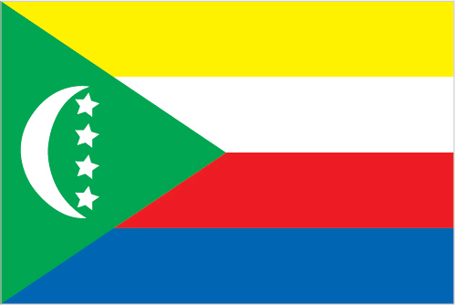
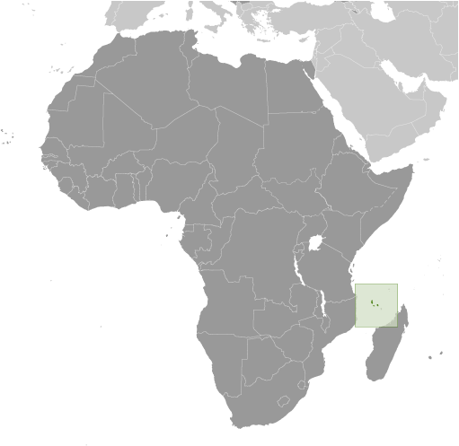


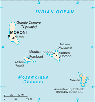
 Image Description
 Image DescriptionThis is the population pyramid for Comoros. A population pyramid illustrates the age and sex structure of a country's population and may provide insights about political and social stability, as well as economic development. The population is distributed along the horizontal axis, with males shown on the left and females on the right. The male and female populations are broken down into 5-year age groups represented as horizontal bars along the vertical axis, with the youngest age groups at the bottom and the oldest at the top. The shape of the population pyramid gradually evolves over time based on fertility, mortality, and international migration trends.