Australia - Oceania ::
Christmas Island
-
Introduction :: Christmas Island
-
Background:Although Europeans had sighted the island at least as early as 1615, it was only named in 1643 for the day of its rediscovery. The island was annexed and settlement began by the UK in 1888 with the discovery of the island's phosphate deposits. Following the Second World War, Christmas Island came under the jurisdiction of the new British Colony of Singapore. The island existed as a separate Crown colony from 1 January 1958 to 1 October 1958 when its transfer to Australian jurisdiction was finalized. That date is still celebrated on the first Monday in October as Territory Day. Almost two-thirds of the island has been declared a national park.
-
Geography :: Christmas Island
-
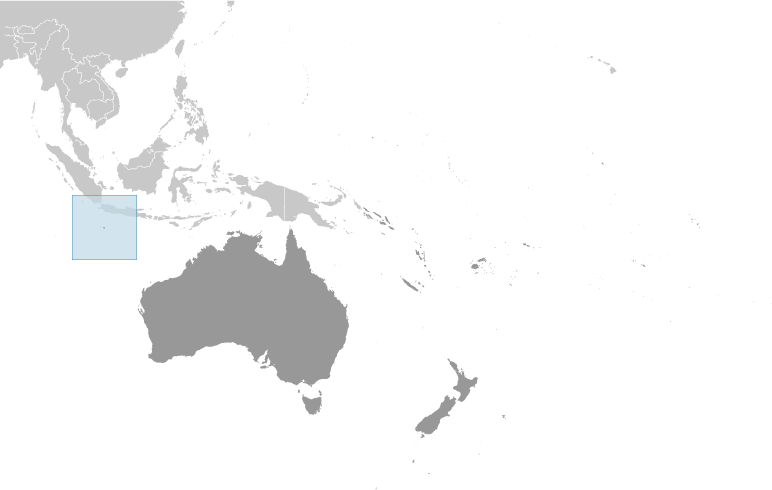
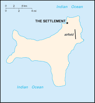
Location:Southeastern Asia, island in the Indian Ocean, south of IndonesiaGeographic coordinates:10 30 S, 105 40 EMap references:Southeast AsiaArea:total: 135 sq kmland: 135 sq kmwater: 0 sq kmcountry comparison to the world: 222Area - comparative:about three-quarters the size of Washington, DCLand boundaries:0 kmCoastline:138.9 kmMaritime claims:territorial sea: 12 nmcontiguous zone: 12 nmexclusive fishing zone: 200 nmClimate:tropical with a wet season (December to April) and dry season; heat and humidity moderated by trade windsTerrain:steep cliffs along coast rise abruptly to central plateauElevation:lowest point: Indian Ocean 0 mhighest point: Murray Hill 361 mNatural resources:phosphate, beachesLand use:agricultural land: 0% (2011 est.)arable land: 0% (2011 est.) / permanent crops: 0% (2011 est.) / permanent pasture: 0% (2011 est.)other: 100% (2011 est.)Irrigated land:NAPopulation distribution:majority of the population lives on the northern tip of the islandNatural hazards:the narrow fringing reef surrounding the island can be a maritime hazardEnvironment - current issues:loss of rainforest; impact of phosphate miningGeography - note:located along major sea lanes of the Indian Ocean
-
People and Society :: Christmas Island
-
Population:2,205 (2016 est.)country comparison to the world: 231Nationality:noun: Christmas Islander(s)adjective: Christmas IslandEthnic groups:Chinese 70%, European 20%, Malay 10% (2001)
note: no indigenous population
Languages:English (official) 27.6%, Mandarin 17.2%, Malay 17.1%, Cantonese 3.9%, Min Nan 1.6%, Tagalog 1%, other 4.5%, unspecified 27.1% (2016 est.)note: data represent language spoken at home
Religions:Muslim 19.4%, Buddhist 18.3%, Roman Catholic 8.8%, Protestant 6.5% (includes Anglican 3.6%, Uniting Church 1.2%, other 1.7%), other Christian 3.3%, other 0.6%, none 15.3%, unspecified 27.7% (2016 est.)Age structure:0-14 years: 12.79% (male 147/female 135) (2017 est.)15-24 years: 12.2% (male 202/female 67) (2017 est.)25-54 years: 57.91% (male 955/female 322) (2017 est.)55-64 years: 11.66% (male 172/female 85) (2017 est.)65 years and over: 5.44% (male 84/female 36) (2017 est.)population pyramid: The World Factbook Field Image ModalAustralia - Oceania :: Christmas Island Print
 Image DescriptionThis is the population pyramid for Christmas Island. A population pyramid illustrates the age and sex structure of a country's population and may provide insights about political and social stability, as well as economic development. The population is distributed along the horizontal axis, with males shown on the left and females on the right. The male and female populations are broken down into 5-year age groups represented as horizontal bars along the vertical axis, with the youngest age groups at the bottom and the oldest at the top. The shape of the population pyramid gradually evolves over time based on fertility, mortality, and international migration trends.
For additional information, please see the entry for Population pyramid on the Definitions and Notes page under the References tab.Population growth rate:1.11% (2014 est.)country comparison to the world: 97Population distribution:majority of the population lives on the northern tip of the islandSex ratio:NAInfant mortality rate:total: NA (2018)male: NAfemale: NALife expectancy at birth:total population: NA (2017 est.)male: NAfemale: NATotal fertility rate:NAHIV/AIDS - adult prevalence rate:NAHIV/AIDS - people living with HIV/AIDS:NAHIV/AIDS - deaths:NA -
Government :: Christmas Island
-
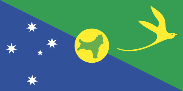
Country name:conventional long form: Territory of Christmas Islandconventional short form: Christmas Islandetymology: named by English Captain William MYNORS for the day of its rediscovery, Christmas Day (25 December 1643); the island had been sighted by Europeans as early as 1615Dependency status:non-self governing territory of Australia; administered from Canberra by the Department of Regional Australia, Local Government, Arts and SportGovernment type:non-self-governing overseas territory of AustraliaCapital:name: The Settlement (Flying Fish Cove)geographic coordinates: 10 25 S, 105 43 Etime difference: UTC+7 (12 hours ahead of Washington, DC, during Standard Time)etymology: self-descriptive name for the main locus of populationAdministrative divisions:none (territory of Australia)Independence:none (territory of Australia)National holiday:Australia Day (commemorates the arrival of the First Fleet of Australian settlers), 26 January (1788)Constitution:history: 1 October 1958 (Christmas Island Act 1958)amendments: amended many times, last in 2016 (2017)Legal system:legal system is under the authority of the governor general of Australia and Australian lawCitizenship:see AustraliaSuffrage:18 years of ageExecutive branch:chief of state: Queen ELIZABETH II (since 6 February 1952); represented by Governor General of the Commonwealth of Australia General Sir Peter COSGROVE (since 28 March 2014)head of government: Administrator Natasha GRIGGS (since 5 October 2018)elections/appointments: the monarchy is hereditary; governor general appointed by the monarch on the recommendation of the Australian prime minister; administrator appointed by the governor general of Australia for a 2-year term and represents the monarch and AustraliaLegislative branch:description: unicameral Christmas Island Shire Council (9 seats; members directly elected by simple majority vote to serve 4-year terms with a portion of the membership renewed every 2 years)elections: held every 2 years with half the members standing for election; last held on 21 October 2017 (next to be held in October 2019)election results: percent of vote - NA; seats by party - independent 9; composition as of 17 October 2015 - men 7, women 2, percent of women 22.2%Judicial branch:under the terms of the Territorial Law Reform Act 1992, Western Australia provides court services as needed for the island, including the Supreme Court and subordinate courts (District Court, Magistrate Court, Family Court, Children's Court, and Coroners' Court)Political parties and leaders:noneInternational organization participation:noneDiplomatic representation in the US:none (territory of Australia)Diplomatic representation from the US:none (territory of Australia)Flag description:territorial flag; divided diagonally from upper hoist to lower fly; the upper triangle is green with a yellow image of the Golden Bosun Bird superimposed; the lower triangle is blue with the Southern Cross constellation, representing Australia, superimposed; a centered yellow disk displays a green map of the island
note: the flag of Australia is used for official purposes
National symbol(s):golden bosun birdNational anthem:note: as a territory of Australia, "Advance Australia Fair" remains official as the national anthem, while "God Save the Queen" serves as the royal anthem (see Australia)
-
Economy :: Christmas Island
-
Economy - overview:The main economic activities on Christmas Island are the mining of low grade phosphate, limited tourism, the provision of government services and, since 2005, the construction and operation of the Immigration Detention Center. The government sector includes administration, health, education, policing, customs, quarantine, and defense.GDP (purchasing power parity):
NA
Agriculture - products:NAIndustries:tourism, phosphate extraction (near depletion)Labor force:NABudget:revenues: NAexpenditures: NAFiscal year:1 July - 30 JuneExports:NA
Exports - commodities:phosphateImports:NA
Imports - commodities:consumer goodsStock of direct foreign investment - at home:(31 December 2009 est.)Exchange rates:Australian dollars (AUD) per US dollar -1.311 (2017 est.)1.3442 (2016 est.)1.3442 (2015)1.3291 (2014 est.)1.1094 (2013 est.) -
Communications :: Christmas Island
-
Telephone system:general assessment: service provided by the Australian networkdomestic: local area code - 08; GSM mobile-cellular telephone service is provided by Telstra as part of the Australian networkinternational: international code - 61 8; ASC submarine cable to Singapore and Australia; satellite earth station - 1 (Intelsat provides telephone and telex service) (2019)Broadcast media:1 community radio station; satellite broadcasts of several Australian radio and TV stations (2017)Internet country code:.cxInternet users:total: 790percent of population: 35.8% (July 2016 est.)country comparison to the world: 224
-
Military and Security :: Christmas Island
-
Military - note:defense is the responsibility of Australia
-
Transportation :: Christmas Island
-
Airports:1 (2013)country comparison to the world: 217Airports - with paved runways:total: 1 (2019)1,524 to 2,437 m: 1Railways:total: 18 km (2017)standard gauge: 18 km 1.435-m (not in operation) (2017)
note: the 18-km Christmas Island Phosphate Company Railway between Flying Fish Cove and South Point was decommissioned in 1987; some tracks and scrap remain in place
country comparison to the world: 134Roadways:total: 140 km (2011)paved: 30 km (2011)unpaved: 110 km (2011)country comparison to the world: 204Ports and terminals:major seaport(s): Flying Fish Cove -
Transnational Issues :: Christmas Island
-
Disputes - international:
none