
Australia - Oceania ::
Midway Islands
-
Introduction :: Midway Islands
-
Background:The US took formal possession of the islands in 1867. The laying of the trans-Pacific cable, which passed through the islands, brought the first residents in 1903. Between 1935 and 1947, Midway was used as a refueling stop for trans-Pacific flights. The US naval victory over a Japanese fleet off Midway in 1942 was one of the turning points of World War II. The islands continued to serve as a naval station until closed in 1993. Today the islands are a US National Wildlife Refuge. From 1996 to 2002 and 2008 to 2012 the refuge was open to the public, but it is now closed.
-
Geography :: Midway Islands
-
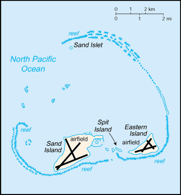
Location:Oceania, atoll in the North Pacific Ocean, about one-third of the way from Honolulu to TokyoGeographic coordinates:28 12 N, 177 22 WMap references:OceaniaArea:total: 6.2 sq kmland: 6.2 sq kmwater: 0 sq km
note: includes Eastern Island, Sand Island, and Spit Island
country comparison to the world: 247Area - comparative:about nine times the size of The Mall in Washington, DCLand boundaries:0 kmCoastline:15 kmMaritime claims:territorial sea: 12 nmexclusive economic zone: 200 nmClimate:subtropical; moderated by prevailing easterly windsTerrain:low, nearly flatElevation:lowest point: Pacific Ocean 0 mhighest point: water tower hill on Sand Island 15 mNatural resources:terrestrial and aquatic wildlifeLand use:agricultural land: 0% (2011 est.)arable land: 0% (2011 est.) / permanent crops: 0% (2011 est.) / permanent pasture: 0% (2011 est.)forest: 0% (2011 est.)other: 100% (2011 est.)Irrigated land:0 sq km (2012)Natural hazards:tropical stormsEnvironment - current issues:small plastic ocean debris mistaken for fish or squid by birds is fed to fledglings resulting in starvation; fishing nets that wash ashore entangle wildlife resulting in starvation or strangulationGeography - note:the coral atoll is managed as a national wildlife refuge and was open to the public for ecotourism from 1996 to 2002 and then again from 2008 to 2012; in 2000, the lands and waters of the Midway National Wildlife Refuge were also designated as the Battle of Midway National Monument; Henderson Airfield on Sand Island continues to serve as an emergency landing field for military and civilian aircraft transiting the Pacific Ocean -
People and Society :: Midway Islands
-
Population:no indigenous inhabitants; approximately 40 people make up the staff of US Fish and Wildlife Service and their services contractor living at the atoll (July 2014 est.)Education expenditures:NA
-
Government :: Midway Islands
-
Country name:conventional long form: noneconventional short form: Midway Islandsetymology: originally named the Middlebrook Islands after the US captain who discovered them in 1859; the name became Midway later in the 19th century and reflects the islands' position in the North Pacific Ocean roughly equidistant between North America and AsiaDependency status:unincorporated unorganized territory of the US; formerly administered from Washington, DC, by the US Navy; on 31 October 1996, through a presidential executive order, the jurisdiction and control of the atoll was transferred to the Fish and Wildlife Service of the US Department of the Interior as part of the National Wildlife Refuge SystemLegal system:the laws of the US apply where applicableCitizenship:see United StatesFlag description:the flag of the US is used
-
Military and Security :: Midway Islands
-
Military - note:defense is the responsibility of the US
-
Transportation :: Midway Islands
-
Airports - with paved runways:total: 2 (2013)1,524 to 2,437 m: 2 (2013)Airports - with unpaved runways:total: 1 (2013)914 to 1,523 m: 1 (2013)Roadways:Ports and terminals:major seaport(s): Sand IslandTransportation - note:Henderson Field on Sand Island serves as an emergency landing site for aircraft crossing the Pacific Ocean
-
Transnational Issues :: Midway Islands
-
Disputes - international:
none