
East Asia/Southeast Asia ::
Paracel Islands
-
Introduction :: Paracel Islands
-
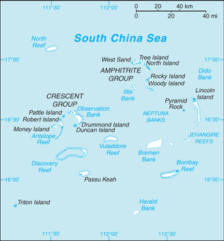
Background:The Paracel Islands are surrounded by productive fishing grounds and by potential oil and gas reserves. In 1932, French Indochina annexed the islands and set up a weather station on Pattle Island; maintenance was continued by its successor, Vietnam. China has occupied all the Paracel Islands since 1974, when its troops seized a South Vietnamese garrison occupying the western islands. China built a military installation on Woody Island with an airfield and artificial harbor. The islands also are claimed by Taiwan and Vietnam.
-
Geography :: Paracel Islands
-
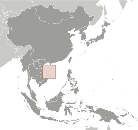
Location:Southeastern Asia, group of small islands and reefs in the South China Sea, about one-third of the way from central Vietnam to the northern PhilippinesGeographic coordinates:16 30 N, 112 00 EMap references:Southeast AsiaArea:total: 7.75 sq km ca.land: 7.75 sq km ca.water: 0 sq kmcountry comparison to the world: 244Area - comparative:land area is about 13 times the size of the National Mall in Washington, DCLand boundaries:0 kmCoastline:518 kmMaritime claims:NAClimate:tropicalTerrain:mostly low and flatElevation:lowest point: South China Sea 0 mhighest point: unnamed location on Rocky Island 14 mNatural resources:noneLand use:agricultural land: 0% (2011 est.)arable land: 0% (2011 est.) / permanent crops: 0% (2011 est.) / permanent pasture: 0% (2011 est.)forest: 0% (2011 est.)other: 100% (2011 est.)Irrigated land:0 sq km (2012)Population distribution:a population of over 1,000 Chinese resides on Woody Island, the largest of the Paracels; there are scattered Chinese garrisons on some other islandsNatural hazards:typhoonsEnvironment - current issues:China's use of dredged sand and coral to build artificial islands harms reef systems; ongoing human activities, including military operations, infrastructure construction, and tourism endangers local ecosystem including birds, fish, marine mammals, and marine reptilesGeography - note:composed of 130 small coral islands and reefs divided into the northeast Amphitrite Group and the western Crescent Group
-
People and Society :: Paracel Islands
-
Population:1,440 (2014 est.)
note: Chinese activity has increased in recent years, particularly on Woody Island, where the population exceeds 1,000; there are scattered Chinese garrisons on some other islands
country comparison to the world: 234Population distribution:a population of over 1,000 Chinese resides on Woody Island, the largest of the Paracels; there are scattered Chinese garrisons on some other islands -
Government :: Paracel Islands
-
Country name:conventional long form: noneconventional short form: Paracel Islandsetymology: Portuguese navigators began to refer to the "Ilhas do Pracel" in the 16th century as a designation of low lying islets, sandbanks, and reefs scattered over a wide area; over time the name changed to "parcel" and then "paracel"
-
Economy :: Paracel Islands
-
Economy - overview:The islands have the potential for oil and gas development. Waters around the islands support commercial fishing, but the islands themselves are not populated on a permanent basis.
-
Military and Security :: Paracel Islands
-
Military - note:occupied by China
-
Transportation :: Paracel Islands
-
Airports:1 (2013)country comparison to the world: 233Airports - with paved runways:total: 1 (2017)1,524 to 2,437 m: 1 (2017)Roadways:Ports and terminals:small Chinese port facilities on Woody Island and Duncan Island
-
Transnational Issues :: Paracel Islands
-
Disputes - international:
occupied by China, also claimed by Taiwan and Vietnam