Main Content


South America
::
South Georgia and South Sandwich Islands
Print
Page last updated on December 18, 2019
The World Factbook
Country/Location Flag Modal
South America ::
South Georgia and South Sandwich Islands
Print
Flag Description
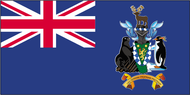
blue with the flag of the UK in the upper hoist-side quadrant and the South Georgia and South Sandwich Islands coat of arms centered on the outer half of the flag; the coat of arms features a shield with a golden lion rampant, holding a torch; the shield is supported by a fur seal on the left and a Macaroni penguin on the right; a reindeer appears above the crest, and below the shield on a scroll is the motto LEO TERRAM PROPRIAM PROTEGAT (Let the Lion Protect its Own Land); the lion with the torch represents the UK and discovery; the background of the shield, blue and white estoiles, are found in the coat of arms of James Cook, discoverer of the islands; all the outer supporting animals represented are native to the islands
The World Factbook
Country/Location Locator Map Modal
South America ::
South Georgia and South Sandwich Islands
Print

The World Factbook
Country/Location Photo Gallery Modal
South America ::
South Georgia and South Sandwich Islands

1 /
1
Caption
An oblique view of the rugged and isolated landscape on the northern shore of South Georgia Island. The high mountains protect the north and eastern coast of the island from the prevailing gales coming from Antarctica and the west. The steep topography also makes deep embayments along the coast that provide habitat for wildlife and anchorages for whaling ships. The island supports major rookeries of penguins and albatrosses, and large seal populations. This view centers on Mt. Paget and Cumberland Bay. Image courtesy of NASA.
Dimensions
File Size
Download
Usage
Factbook photos - obtained from a variety of sources - are in the public domain
and are copyright free.
Agency Copyright Notice
Agency Copyright Notice
-
Introduction :: South Georgia and South Sandwich Islands
-
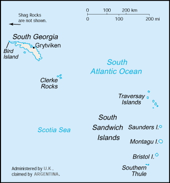
 The islands, with large bird and seal populations, lie approximately 1,000 km east of the Falkland Islands and have been under British administration since 1908 - except for a brief period in 1982 when Argentina occupied them. Grytviken, on South Georgia, was a 19th and early 20th century whaling station. Famed explorer Ernest SHACKLETON stopped there in 1914 en route to his ill-fated attempt to cross Antarctica on foot. He returned some 20 months later with a few companions in a small boat and arranged a successful rescue for the rest of his crew, stranded off the Antarctic Peninsula. He died in 1922 on a subsequent expedition and is buried in Grytviken. Today, the station houses scientists from the British Antarctic Survey. Recognizing the importance of preserving the marine stocks in adjacent waters, the UK, in 1993, extended the exclusive fishing zone from 12 nm to 200 nm around each island.
 -
Geography :: South Georgia and South Sandwich Islands
-
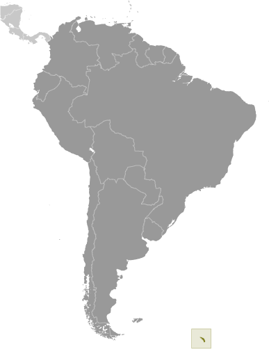
Southern South America, islands in the South Atlantic Ocean, east of the tip of South America
54 30 S, 37 00 W
Antarctic Region
total: 3,903 sq kmland: 3,903 sq kmwater: 0 sq km
note: includes Shag Rocks, Black Rock, Clerke Rocks, South Georgia Island, Bird Island, and the South Sandwich Islands, which consist of 11 islands
country comparison to the world: 177
slightly larger than Rhode Island
0 km
NA
territorial sea: 12 nmexclusive fishing zone: 200 nm
variable, with mostly westerly winds throughout the year interspersed with periods of calm; nearly all precipitation falls as snow
most of the islands are rugged and mountainous rising steeply from the sea; South Georgia is largely barren with steep, glacier-covered mountains; the South Sandwich Islands are of volcanic origin with some active volcanoes
lowest point: Atlantic Ocean 0 mhighest point: Mount Paget (South Georgia) 2,934 m
fish
agricultural land: 0% (2011 est.)arable land: 0% (2011 est.) / permanent crops: 0% (2011 est.) / permanent pasture: 0% (2011 est.)forest: 0% (2011 est.)other: 100% (2011 est.)
0 sq km (2011)
the South Sandwich Islands have prevailing weather conditions that generally make them difficult to approach by ship; they are also subject to active volcanism
reindeer - introduced to the islands in the 20th century - devastated the native flora and bird species; some reindeer were translocated to the Falkland Islands in 2001, the rest were exterminated (2013-14); a parallel effort (2010-15) eradicated rats and mice that came to the islands as stowaways on ships as early as the late 18th century
the north coast of South Georgia has several large bays, which provide good anchorage -
People and Society :: South Georgia and South Sandwich Islands
-
no indigenous inhabitants
note: the small military garrison on South Georgia withdrew in March 2001, replaced by a permanent group of scientists of the British Antarctic Survey, which also has a biological station on Bird Island; the South Sandwich Islands are uninhabited
-
Government :: South Georgia and South Sandwich Islands
-
conventional long form: South Georgia and the South Sandwich Islandsconventional short form: South Georgia and South Sandwich Islandsabbreviation: SGSSIetymology: South Georgia was named "the Isle of Georgia" in 1775 by Captain James COOK in honor of British King GEORGE III; the explorer also discovered the Sandwich Islands Group that year, which he named "Sandwich Land" after John MONTAGU, the Earl of Sandwich and First Lord of the Admiralty; the word "South" was later added to distinguish these islands from the other Sandwich Islands, now known as the Hawaiian Islands
overseas territory of the UK, also claimed by Argentina; administered from the Falkland Islands by a commissioner, who is concurrently governor of the Falkland Islands, representing Queen ELIZABETH II
the laws of the UK, where applicable, apply
UPU
none (overseas territory of the UK, also claimed by Argentina)
none (overseas territory of the UK, also claimed by Argentina)
blue with the flag of the UK in the upper hoist-side quadrant and the South Georgia and South Sandwich Islands coat of arms centered on the outer half of the flag; the coat of arms features a shield with a golden lion rampant, holding a torch; the shield is supported by a fur seal on the left and a Macaroni penguin on the right; a reindeer appears above the crest, and below the shield on a scroll is the motto LEO TERRAM PROPRIAM PROTEGAT (Let the Lion Protect its Own Land); the lion with the torch represents the UK and discovery; the background of the shield, blue and white estoiles, are found in the coat of arms of James Cook, discoverer of the islands; all the outer supporting animals represented are native to the islands
-
Economy :: South Georgia and South Sandwich Islands
-
Some fishing takes place in adjacent waters. Harvesting finfish and krill are potential sources of income. The islands receive income from postage stamps produced in the UK, the sale of fishing licenses, and harbor and landing fees from tourist vessels. Tourism from specialized cruise ships is increasing rapidly.
-
Communications :: South Georgia and South Sandwich Islands
-
Military and Security :: South Georgia and South Sandwich Islands
-
defense is the responsibility of the UK
-
Transportation :: South Georgia and South Sandwich Islands
-
major seaport(s): Grytviken
-
Transnational Issues :: South Georgia and South Sandwich Islands
-
Argentina, which claims the islands in its constitution and briefly occupied them by force in 1982, agreed in 1995 to no longer seek settlement by force