Main Content
![](../attachments/flags/TL-flag.gif)
![Locator Map for Tokelau](../attachments/locator-maps/TL-locator-map.gif)
![Nukunonu is the largest of the three islands that comprise Tokelau. It is composed of a roughly tear-drop shaped atoll that includes 5.5 sq km of land and whose central lagoon encompasses an area of about 90 sq km. Image courtesy of NASA.](../attachments/images/thumb/TL_004_large.jpg?1528325146)
![Fakaofo is one of the three islands that make up Tokelau. Its land area is only 3 sq km; the lagoon covers an area of about 45 sq km. Image courtesy of NASA.](../attachments/images/thumb/TL_001_large.jpg?1528325147)
![At roughly 8 km (5 mi) wide, Atafu Atoll is the smallest of three atolls comprising Tokelau. Land area is only about 2.5 sq km and the lagoon's area is about 15 sq km. The primary settlement on Atafu is a village located at the northwestern corner of the atoll - indicated by an area of light gray dots in the left part of this photograph. The typical ring shape of the atoll is the result of coral reefs building up around a former volcanic island. Over geologic time, the central volcano subsided beneath the water surface, leaving the fringing reefs and a central lagoon that contains submerged coral reefs. Image courtesy of NASA.](../attachments/images/thumb/TL_002_large.jpg?1528325147)
![Nukunonu is the largest of the three islands that comprise Tokelau. It is composed of a roughly tear-drop shaped atoll that includes 5.5 sq km of land and whose central lagoon encompasses an area of about 90 sq km. Image courtesy of NASA.](../attachments/images/large/TL_004_large.jpg?1528325146)
Agency Copyright Notice
![Fakaofo is one of the three islands that make up Tokelau. Its land area is only 3 sq km; the lagoon covers an area of about 45 sq km. Image courtesy of NASA.](../attachments/images/large/TL_001_large.jpg?1528325147)
Agency Copyright Notice
![At roughly 8 km (5 mi) wide, Atafu Atoll is the smallest of three atolls comprising Tokelau. Land area is only about 2.5 sq km and the lagoon's area is about 15 sq km. The primary settlement on Atafu is a village located at the northwestern corner of the atoll - indicated by an area of light gray dots in the left part of this photograph. The typical ring shape of the atoll is the result of coral reefs building up around a former volcanic island. Over geologic time, the central volcano subsided beneath the water surface, leaving the fringing reefs and a central lagoon that contains submerged coral reefs. Image courtesy of NASA.](../attachments/images/large/TL_002_large.jpg?1528325147)
Agency Copyright Notice
-
Jump to topic
- Introduction
- Geography
-
People and Society
- Drinking water source
- Education expenditures
- Ethnic groups
- HIV/AIDS - adult prevalence rate
- HIV/AIDS - deaths
- HIV/AIDS - people living with HIV/AIDS
- Infant mortality rate
- Languages
- Life expectancy at birth
- Nationality
- Physicians density
- Population
- Population distribution
- Population growth rate
- Religions
- Sanitation facility access
- Sex ratio
- Total fertility rate
- Urbanization
-
Government
- Administrative divisions
- Capital
- Citizenship
- Constitution
- Country name
- Dependency status
- Diplomatic representation from the US
- Diplomatic representation in the US
- Executive branch
- Flag description
- Government type
- Independence
- International organization participation
- Judicial branch
- Legal system
- Legislative branch
- National anthem
- National holiday
- National symbol(s)
- Political parties and leaders
- Suffrage
-
Economy
- Agriculture - products
- Budget
- Economy - overview
- Exchange rates
- Exports
- Exports - commodities
- Fiscal year
- GDP - composition, by sector of origin
- GDP - per capita (PPP)
- GDP - real growth rate
- GDP (official exchange rate)
- GDP (purchasing power parity)
- Imports
- Imports - commodities
- Industries
- Inflation rate (consumer prices)
- Labor force
- Population below poverty line
- Unemployment rate
- Energy
- Communications
- Military and Security
- Transportation
- Transnational Issues
-
Introduction :: Tokelau
-
Background: This entry usually highlights major historic events and current issues and may include a statement about one or two key future trends.Originally settled by Polynesian emigrants from surrounding island groups, the Tokelau Islands were made a British protectorate in 1889. They were transferred to New Zealand administration in 1925. Referenda held in 2006 and 2007 to change the status of the islands from that of a New Zealand territory to one of free association with New Zealand did not meet the needed threshold for approval.
-
Geography :: Tokelau
-
Location: This entry identifies the country's regional location, neighboring countries, and adjacent bodies of water.
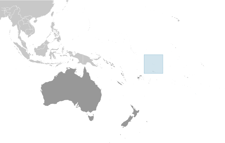
Oceania, group of three atolls in the South Pacific Ocean, about one-half of the way from Hawaii to New ZealandGeographic coordinates: This entry includes rounded latitude and longitude figures for the centroid or center point of a country expressed in degrees and minutes; it is based on the locations provided in the Geographic Names Server (GNS), maintained by the National Geospatial-Intelligence Agency on behalf of the US Board on Geographic Names.9 00 S, 172 00 WMap references: This entry includes the name of the Factbook reference map on which a country may be found. Note that boundary representations on these maps are not necessarily authoritative. The entry on Geographic coordinates may be helpful in finding some smaller countries.OceaniaArea: This entry includes three subfields. Total area is the sum of all land and water areas delimited by international boundaries and/or coastlines. Land area is the aggregate of all surfaces delimited by international boundaries and/or coastlines, excluding inland water bodies (lakes, reservoirs, rivers). Water area is the sum of the surfaces of all inland water bodies, such as lakes, reservoirs, or rivers, as delimited by international boundaries and/or coastlines.Area - comparative: This entry provides an area comparison based on total area equivalents. Most entities are compared with the entire US or one of the 50 states based on area measurements (1990 revised) provided by the US Bureau of the Census. The smaller entities are compared with Washington, DC (178 sq km, 69 sq mi) or The Mall in Washington, DC (0.59 sq km, 0.23 sq mi, 146 acres).about 17 times the size of the National Mall in Washington, DCLand boundaries: This entry contains the total length of all land boundaries and the individual lengths for each of the contiguous border countries. When available, official lengths published by national statistical agencies are used. Because surveying methods may differ, country border lengths reported by contiguous countries may differ.0 kmCoastline: This entry gives the total length of the boundary between the land area (including islands) and the sea.101 kmMaritime claims: This entry includes the following claims, the definitions of which are excerpted from the United Nations Convention on the Law of the Sea (UNCLOS), which alone contains the full and definitive descriptions: territorial sea - the sovereignty of a coastal state extends beyond its land territory and internal waters to an adjacent belt of sea, described as the territorial sea in the UNCLOS (Part II); this sovereignty extends to the air space over the territorial sea as well as its underlying s . . . moreterritorial sea: 12 nmexclusive economic zone: 200 nmClimate: This entry includes a brief description of typical weather regimes throughout the year; in the Word entry only, it includes four subfields that describe climate extremes:ten driest places on earth (average annual precipitation) describes the annual average precipitation measured in both millimeters and inches for selected countries with climate extremes. ten wettest places on earth (average annual precipitation) describes the annual average precipitation measured in both millimeters and i . . . moretropical; moderated by trade winds (April to November)Terrain: This entry contains a brief description of the topography.low-lying coral atolls enclosing large lagoonsElevation: This entry includes the mean elevation and elevation extremes, lowest point and highest point.lowest point: Pacific Ocean 0 mhighest point: unnamed location 5 mNatural resources: This entry lists a country's mineral, petroleum, hydropower, and other resources of commercial importance, such as rare earth elements (REEs). In general, products appear only if they make a significant contribution to the economy, or are likely to do so in the future.NEGLLand use: This entry contains the percentage shares of total land area for three different types of land use: agricultural land, forest, and other; agricultural land is further divided into arable land - land cultivated for crops like wheat, maize, and rice that are replanted after each harvest, permanent crops - land cultivated for crops like citrus, coffee, and rubber that are not replanted after each harvest, and includes land under flowering shrubs, fruit trees, nut trees, and vines, and permane . . . moreagricultural land: 60% (2011 est.)arable land: 0% (2011 est.) / permanent crops: 60% (2011 est.) / permanent pasture: 0% (2011 est.)forest: 0% (2011 est.)other: 40% (2011 est.)Irrigated land: This entry gives the number of square kilometers of land area that is artificially supplied with water.0 sq km (2012)Population distribution: This entry provides a summary description of the population dispersion within a country. While it may suggest population density, it does not provide density figures.the country's small population is fairly evenly distributed amongst the three atollsNatural hazards: This entry lists potential natural disasters. For countries where volcanic activity is common, a volcanism subfield highlights historically active volcanoes.lies in Pacific cyclone beltEnvironment - current issues: This entry lists the most pressing and important environmental problems. The following terms and abbreviations are used throughout the entry: Acidification - the lowering of soil and water pH due to acid precipitation and deposition usually through precipitation; this process disrupts ecosystem nutrient flows and may kill freshwater fish and plants dependent on more neutral or alkaline conditions (see acid rain). Acid rain - characterized as containing harmful levels of sulfur dioxi . . . moreoverexploitation of certain fish and other marine species, coastal sand, and forest resources; pollution of freshwater lenses and coastal waters from improper disposal of chemicalsGeography - note: This entry includes miscellaneous geographic information of significance not included elsewhere.
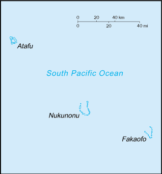
consists of three atolls (Atafu, Fakaofo, Nukunonu), each with a lagoon surrounded by a number of reef-bound islets of varying length and rising to over 3 m above sea level
-
People and Society :: Tokelau
-
Population: This entry gives an estimate from the US Bureau of the Census based on statistics from population censuses, vital statistics registration systems, or sample surveys pertaining to the recent past and on assumptions about future trends. The total population presents one overall measure of the potential impact of the country on the world and within its region. Note: Starting with the 1993 Factbook, demographic estimates for some countries (mostly African) have explicitly taken into account t . . . more1,285 (2016 est.)country comparison to the world: 235Nationality: This entry provides the identifying terms for citizens - noun and adjective.noun: Tokelauan(s)adjective: TokelauanEthnic groups: This entry provides an ordered listing of ethnic groups starting with the largest and normally includes the percent of total population.Tokelauan 64.5%, part Tokelauan/Samoan 9.7%, part Tokelauan/Tuvaluan 2.8%, Tuvaluan 7.5%, Samoan 5.8%, other Pacific Islander 3.4%, other 5.6%, unspecified 0.8% (2016 est.)Languages: This entry provides a listing of languages spoken in each country and specifies any that are official national or regional languages. When data is available, the languages spoken in each country are broken down according to the percent of the total population speaking each language as a first language. For those countries without available data, languages are listed in rank order based on prevalence, starting with the most-spoken language.Tokelauan 88.1% (a Polynesian language), English 48.6%, Samoan 26.7%, Tuvaluan 11.2%, Kiribati 1.5%, other 2.8%, none 2.8%, unspecified 0.8% (2016 ests.)
note: shares sum to more than 100% because some respondents gave more than one answer on the census
Religions: This entry is an ordered listing of religions by adherents starting with the largest group and sometimes includes the percent of total population. The core characteristics and beliefs of the world's major religions are described below. Baha'i - Founded by Mirza Husayn-Ali (known as Baha'u'llah) in Iran in 1852, Baha'i faith emphasizes monotheism and believes in one eternal transcendent God. Its guiding focus is to encourage the unity of all peoples on the earth so that justice and peace m . . . moreCongregational Christian Church 50.4%, Roman Catholic 38.7%, Presbyterian 5.9%, other Christian 4.2%, unspecified 0.8% (2016 est.)Population growth rate: The average annual percent change in the population, resulting from a surplus (or deficit) of births over deaths and the balance of migrants entering and leaving a country. The rate may be positive or negative. The growth rate is a factor in determining how great a burden would be imposed on a country by the changing needs of its people for infrastructure (e.g., schools, hospitals, housing, roads), resources (e.g., food, water, electricity), and jobs. Rapid population growth can be seen as . . . more-0.01% (2014 est.)country comparison to the world: 196Population distribution: This entry provides a summary description of the population dispersion within a country. While it may suggest population density, it does not provide density figures.the country's small population is fairly evenly distributed amongst the three atollsUrbanization: This entry provides two measures of the degree of urbanization of a population. The first, urban population, describes the percentage of the total population living in urban areas, as defined by the country. The second, rate of urbanization, describes the projected average rate of change of the size of the urban population over the given period of time. It is possible for a country with a 100% urban population to still display a change in the rate of urbanization (up or down). For example . . . moreurban population: 0% of total population (2019)rate of urbanization: 0% annual rate of change (2015-20 est.)Sex ratio: This entry includes the number of males for each female in five age groups - at birth, under 15 years, 15-64 years, 65 years and over, and for the total population. Sex ratio at birth has recently emerged as an indicator of certain kinds of sex discrimination in some countries. For instance, high sex ratios at birth in some Asian countries are now attributed to sex-selective abortion and infanticide due to a strong preference for sons. This will affect future marriage patterns and fertilit . . . moreNAInfant mortality rate: This entry gives the number of deaths of infants under one year old in a given year per 1,000 live births in the same year. This rate is often used as an indicator of the level of health in a country.total: NA (2018)male: NAfemale: NALife expectancy at birth: This entry contains the average number of years to be lived by a group of people born in the same year, if mortality at each age remains constant in the future. Life expectancy at birth is also a measure of overall quality of life in a country and summarizes the mortality at all ages. It can also be thought of as indicating the potential return on investment in human capital and is necessary for the calculation of various actuarial measures.total population: NA (2017 est.)male: NAfemale: NATotal fertility rate: This entry gives a figure for the average number of children that would be born per woman if all women lived to the end of their childbearing years and bore children according to a given fertility rate at each age. The total fertility rate (TFR) is a more direct measure of the level of fertility than the crude birth rate, since it refers to births per woman. This indicator shows the potential for population change in the country. A rate of two children per woman is considered the replaceme . . . moreNADrinking water source: This entry provides information about access to improved or unimproved drinking water sources available to segments of the population of a country. Improved drinking water - use of any of the following sources: piped water into dwelling, yard, or plot; public tap or standpipe; tubewell or borehole; protected dug well; protected spring; or rainwater collection. Unimproved drinking water - use of any of the following sources: unprotected dug well; unprotected spring; cart with small tank or . . . moreimproved: rural: 100% of populationtotal: 100% of populationunimproved: rural: 0% of populationtotal: 0% of population (2015 est.)Physicians density: This entry gives the number of medical doctors (physicians), including generalist and specialist medical practitioners, per 1,000 of the population. Medical doctors are defined as doctors that study, diagnose, treat, and prevent illness, disease, injury, and other physical and mental impairments in humans through the application of modern medicine. They also plan, supervise, and evaluate care and treatment plans by other health care providers. The World Health Organization estimates that f . . . more2.72 physicians/1,000 population (2010)Sanitation facility access: This entry provides information about access to improved or unimproved sanitation facilities available to segments of the population of a country. Improved sanitation - use of any of the following facilities: flush or pour-flush to a piped sewer system, septic tank or pit latrine; ventilated improved pit (VIP) latrine; pit latrine with slab; or a composting toilet. Unimproved sanitation - use of any of the following facilities: flush or pour-flush not piped to a sewer system, septic tank . . . moreimproved: rural: 90.5% of population (2015 est.)total: 90.5% of population (2015 est.)unimproved: rural: 9.5% of population (2015 est.)total: 9.5% of population (2015 est.)HIV/AIDS - adult prevalence rate: This entry gives an estimate of the percentage of adults (aged 15-49) living with HIV/AIDS. The adult prevalence rate is calculated by dividing the estimated number of adults living with HIV/AIDS at yearend by the total adult population at yearend.NAHIV/AIDS - people living with HIV/AIDS: This entry gives an estimate of all people (adults and children) alive at yearend with HIV infection, whether or not they have developed symptoms of AIDS.NAHIV/AIDS - deaths: This entry gives an estimate of the number of adults and children who died of AIDS during a given calendar year.NAEducation expenditures: This entry provides the public expenditure on education as a percent of GDP.NA -
Government :: Tokelau
-
Country name: This entry includes all forms of the country's name approved by the US Board on Geographic Names (Italy is used as an example): conventional long form (Italian Republic), conventional short form (Italy), local long form (Repubblica Italiana), local short form (Italia), former (Kingdom of Italy), as well as the abbreviation. Also see the Terminology note.conventional long form: noneconventional short form: Tokelauformer: Union Islands, Tokelau Islandsetymology: "tokelau" is a Polynesian word meaning "north wind"Dependency status: This entry describes the formal relationship between a particular nonindependent entity and an independent state.self-administering territory of New Zealand; note - Tokelau and New Zealand have agreed to a draft constitution as Tokelau moves toward free association with New Zealand; a UN-sponsored referendum on self governance in October 2007 did not meet the two-thirds majority vote necessary for changing the political statusGovernment type: This entry gives the basic form of government. Definitions of the major governmental terms are as follows. (Note that for some countries more than one definition applies.): Absolute monarchy - a form of government where the monarch rules unhindered, i.e., without any laws, constitution, or legally organized opposition. Anarchy - a condition of lawlessness or political disorder brought about by the absence of governmental authority. Authoritarian - a form of government in whic . . . more
parliamentary democracy under a constitutional monarchy
Capital: This entry gives the name of the seat of government, its geographic coordinates, the time difference relative to Coordinated Universal Time (UTC) and the time observed in Washington, DC, and, if applicable, information on daylight saving time (DST). Where appropriate, a special note has been added to highlight those countries that have multiple time zones.UTC+13 (18 hours ahead of Washington, DC during Standard Time)Administrative divisions: This entry generally gives the numbers, designatory terms, and first-order administrative divisions as approved by the US Board on Geographic Names (BGN). Changes that have been reported but not yet acted on by the BGN are noted. Geographic names conform to spellings approved by the BGN with the exception of the omission of diacritical marks and special characters.none (territory of New Zealand)Independence: For most countries, this entry gives the date that sovereignty was achieved and from which nation, empire, or trusteeship. For the other countries, the date given may not represent "independence" in the strict sense, but rather some significant nationhood event such as the traditional founding date or the date of unification, federation, confederation, establishment, fundamental change in the form of government, or state succession. For a number of countries, the establishment of statehood . . . morenone (territory of New Zealand)National holiday: This entry gives the primary national day of celebration - usually independence day.Waitangi Day (Treaty of Waitangi established British sovereignty over New Zealand), 6 February (1840)Constitution: This entry provides information on a country’s constitution and includes two subfields. The history subfield includes the dates of previous constitutions and the main steps and dates in formulating and implementing the latest constitution. For countries with 1-3 previous constitutions, the years are listed; for those with 4-9 previous, the entry is listed as “several previous,” and for those with 10 or more, the entry is “many previous.” The amendments subfield summarizes the process of am . . . morehistory: many previous; latest effective 1 January 1949 (Tokelau Islands Act 1948)amendments: proposed as a resolution by the General Fono; passage requires support by each village and approval by the General Fono; amended many times, last in 2007 (2019)Legal system: This entry provides the description of a country's legal system. A statement on judicial review of legislative acts is also included for a number of countries. The legal systems of nearly all countries are generally modeled upon elements of five main types: civil law (including French law, the Napoleonic Code, Roman law, Roman-Dutch law, and Spanish law); common law (including United State law); customary law; mixed or pluralistic law; and religious law (including Islamic law). An addition . . . morecommon law system of New ZealandCitizenship: This entry provides information related to the acquisition and exercise of citizenship; it includes four subfields: citizenship by birth describes the acquisition of citizenship based on place of birth, known as Jus soli, regardless of the citizenship of parents. citizenship by descent only describes the acquisition of citizenship based on the principle of Jus sanguinis, or by descent, where at least one parent is a citizen of the state and being born within the territorial limits of the s . . . moresee New ZealandSuffrage: This entry gives the age at enfranchisement and whether the right to vote is universal or restricted.21 years of age; universalExecutive branch: This entry includes five subentries: chief of state; head of government; cabinet; elections/appointments; election results. Chief of state includes the name, title, and beginning date in office of the titular leader of the country who represents the state at official and ceremonial functions but may not be involved with the day-to-day activities of the government. Head of government includes the name, title of the top executive designated to manage the executive branch of the government, a . . . morechief of state: Queen ELIZABETH II (since 6 February 1952); represented by Governor General of New Zealand Governor General Dame Patricia Lee REDDY (since 28 September 2016); New Zealand is represented by Administrator Jonathan KINGS (since 30 August 2017)head of government: Afega GAULOFA (since 10 March 2016); note - position rotates annually among the three Faipule (village leaders)cabinet: Council for the Ongoing Government of Tokelau (or Tokelau Council) functions as a cabinet; consists of 3 Faipule (village leaders) and 3 Pulenuku (village mayors)elections/appointments: the monarchy is hereditary; governor general appointed by the monarch; administrator appointed by the Minister of Foreign Affairs and Trade in New Zealand; head of government chosen from the Council of Faipule to serve a 1-year termnote: the meeting place of the Tokelau Council rotates annually among the three atolls; this tradition has given rise to the somewhat misleading description that the capital rotates yearly between the three atolls; in actuality, it is the seat of the government councilors that rotates since Tokelau has no capital
Legislative branch: This entry has three subfields. The description subfield provides the legislative structure (unicameral – single house; bicameral – an upper and a lower house); formal name(s); number of member seats; types of constituencies or voting districts (single seat, multi-seat, nationwide); electoral voting system(s); and member term of office. The elections subfield includes the dates of the last election and next election. The election results subfield lists percent of vote by party/coalition an . . . moredescription: unicameral General Fono (20 seats apportioned by island - Atafu 7, Fakaofo 7, Nukunonu 6; members directly elected by simple majority vote to serve 3-year terms); note - the Tokelau Amendment Act of 1996 confers limited legislative power to the General Fonoelections: last held on 23, 27, and 31 January 2017 depending on island (next to be held in 2020)election results: percent of vote by party - NA; seats by party - independent 20; composition - men 17, women 3, percent of women 15%Judicial branch: This entry includes three subfields. The highest court(s) subfield includes the name(s) of a country's highest level court(s), the number and titles of the judges, and the types of cases heard by the court, which commonly are based on civil, criminal, administrative, and constitutional law. A number of countries have separate constitutional courts. The judge selection and term of office subfield includes the organizations and associated officials responsible for nominating and appointing j . . . morehighest courts: Court of Appeal (in New Zealand) (consists of the court president and 8 judges sitting in 3- or 5-judge panels, depending on the case)judge selection and term of office: judges nominated by the Judicial Selection Committee and approved by three-quarters majority of the Parliament; judges serve for lifesubordinate courts: High Court (in New Zealand); Council of Elders or TaupulegaPolitical parties and leaders: This entry includes a listing of significant political parties, coalitions, and electoral lists as of each country's last legislative election, unless otherwise noted.noneInternational organization participation: This entry lists in alphabetical order by abbreviation those international organizations in which the subject country is a member or participates in some other way.PIF (associate member), SPC, UNESCO (associate), UPUDiplomatic representation in the US: This entry includes the chief of mission, chancery address, telephone, FAX, consulate general locations, and consulate locations. The use of the annotated title Appointed Ambassador refers to a new ambassador who has presented his/her credentials to the secretary of state but not the US president. Such ambassadors fulfill all diplomatic functions except meeting with or appearing at functions attended by the president until such time as they formally present their credentials at a White Hou . . . morenone (territory of New Zealand)Diplomatic representation from the US: This entry includes the chief of mission, embassy address, mailing address, telephone number, FAX number, branch office locations, consulate general locations, and consulate locations.none (territory of New Zealand)Flag description: This entry provides a written flag description produced from actual flags or the best information available at the time the entry was written. The flags of independent states are used by their dependencies unless there is an officially recognized local flag. Some disputed and other areas do not have flags.
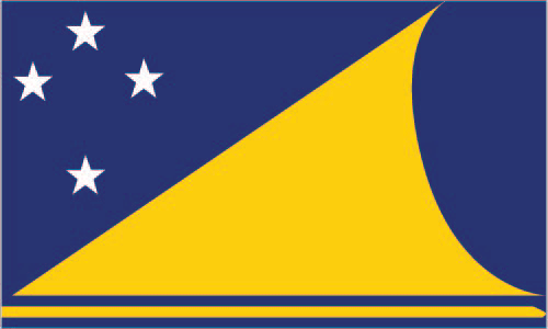
a yellow stylized Tokelauan canoe on a dark blue field sails toward the manu - the Southern Cross constellation of four, white, five-pointed stars at the hoist side; the Southern Cross represents the role of Christianity in Tokelauan culture and, in conjunction with the canoe, symbolizes the country navigating into the future; the color yellow indicates happiness and peace, and the blue field represents the ocean on which the community reliesNational symbol(s): A national symbol is a faunal, floral, or other abstract representation - or some distinctive object - that over time has come to be closely identified with a country or entity. Not all countries have national symbols; a few countries have more than one.tuluma (fishing tackle box); national colors: blue, yellow, whiteNational anthem: A generally patriotic musical composition - usually in the form of a song or hymn of praise - that evokes and eulogizes the history, traditions, or struggles of a nation or its people. National anthems can be officially recognized as a national song by a country's constitution or by an enacted law, or simply by tradition. Although most anthems contain lyrics, some do not.name: "Te Atua" (For the Almighty)lyrics/music: unknown/Falani KALOLOnote: adopted 2008; in preparation for eventual self governance, Tokelau held a national contest to choose an anthem; as a territory of New Zealand, "God Defend New Zealand" and "God Save the Queen" are official (see New Zealand)
-
Economy :: Tokelau
-
Economy - overview: This entry briefly describes the type of economy, including the degree of market orientation, the level of economic development, the most important natural resources, and the unique areas of specialization. It also characterizes major economic events and policy changes in the most recent 12 months and may include a statement about one or two key future macroeconomic trends.
Tokelau's small size (three villages), isolation, and lack of resources greatly restrain economic development and confine agriculture to the subsistence level. The principal sources of revenue are from sales of copra, postage stamps, souvenir coins, and handicrafts. Money is also remitted to families from relatives in New Zealand.
The people rely heavily on aid from New Zealand - about $15 million annually in FY12/13 and FY13/14 - to maintain public services. New Zealand's support amounts to 80% of Tokelau's recurrent government budget. An international trust fund, currently worth nearly $32 million, was established in 2004 by New Zealand to provide Tokelau an independent source of revenue.
GDP (purchasing power parity): This entry gives the gross domestic product (GDP) or value of all final goods and services produced within a nation in a given year. A nation's GDP at purchasing power parity (PPP) exchange rates is the sum value of all goods and services produced in the country valued at prices prevailing in the United States in the year noted. This is the measure most economists prefer when looking at per-capita welfare and when comparing living conditions or use of resources across countries. The measur . . . more$1.5 million (1993 est.)country comparison to the world: 229GDP (official exchange rate): This entry gives the gross domestic product (GDP) or value of all final goods and services produced within a nation in a given year. A nation's GDP at official exchange rates (OER) is the home-currency-denominated annual GDP figure divided by the bilateral average US exchange rate with that country in that year. The measure is simple to compute and gives a precise measure of the value of output. Many economists prefer this measure when gauging the economic power an economy maintains vis- . . . moreNAGDP - real growth rate: This entry gives GDP growth on an annual basis adjusted for inflation and expressed as a percent. The growth rates are year-over-year, and not compounded.NA
GDP - per capita (PPP): This entry shows GDP on a purchasing power parity basis divided by population as of 1 July for the same year.$1,000 (1993 est.)country comparison to the world: 225GDP - composition, by sector of origin: This entry shows where production takes place in an economy. The distribution gives the percentage contribution of agriculture, industry, and services to total GDP, and will total 100 percent of GDP if the data are complete. Agriculture includes farming, fishing, and forestry. Industry includes mining, manufacturing, energy production, and construction. Services cover government activities, communications, transportation, finance, and all other private economic activities that do not prod . . . moreagriculture: NAindustry: NAservices: NAAgriculture - products: This entry is an ordered listing of major crops and products starting with the most important.coconuts, copra, breadfruit, papayas, bananas; pigs, poultry, goats; fishIndustries: This entry provides a rank ordering of industries starting with the largest by value of annual output.small-scale enterprises for copra production, woodworking, plaited craft goods; stamps, coins; fishingLabor force: This entry contains the total labor force figure.440 (2001)country comparison to the world: 231Unemployment rate: This entry contains the percent of the labor force that is without jobs. Substantial underemployment might be noted.NA
Population below poverty line: National estimates of the percentage of the population falling below the poverty line are based on surveys of sub-groups, with the results weighted by the number of people in each group. Definitions of poverty vary considerably among nations. For example, rich nations generally employ more generous standards of poverty than poor nations.NABudget: This entry includes revenues, expenditures, and capital expenditures. These figures are calculated on an exchange rate basis, i.e., not in purchasing power parity (PPP) terms.revenues: 430,800 (1987 est.)expenditures: 2.8 million (1987 est.)Fiscal year: This entry identifies the beginning and ending months for a country's accounting period of 12 months, which often is the calendar year but which may begin in any month. All yearly references are for the calendar year (CY) unless indicated as a noncalendar fiscal year (FY).1 April - 31 MarchInflation rate (consumer prices): This entry furnishes the annual percent change in consumer prices compared with the previous year's consumer prices.NA
Exports: This entry provides the total US dollar amount of merchandise exports on an f.o.b. (free on board) basis. These figures are calculated on an exchange rate basis, i.e., not in purchasing power parity (PPP) terms.$0 (2002 est.)country comparison to the world: 224Exports - commodities: This entry provides a listing of the highest-valued exported products; it sometimes includes the percent of total dollar value.stamps, copra, handicraftsImports: This entry provides the total US dollar amount of merchandise imports on a c.i.f. (cost, insurance, and freight) or f.o.b. (free on board) basis. These figures are calculated on an exchange rate basis, i.e., not in purchasing power parity (PPP) terms.$969,200 (2002 est.)country comparison to the world: 224Imports - commodities: This entry provides a listing of the highest-valued imported products; it sometimes includes the percent of total dollar value.foodstuffs, building materials, fuelExchange rates: This entry provides the average annual price of a country's monetary unit for the time period specified, expressed in units of local currency per US dollar, as determined by international market forces or by official fiat. The International Organization for Standardization (ISO) 4217 alphabetic currency code for the national medium of exchange is presented in parenthesis. Closing daily exchange rates are not presented in The World Factbook, but are used to convert stock values - e.g., the . . . moreNew Zealand dollars (NZD) per US dollar -1.416 (2017 est.)1.4279 (2016 est.)1.4279 (2015)1.4279 (2014 est.)1.2039 (2013 est.) -
Energy :: Tokelau
-
Crude oil - proved reserves: This entry is the stock of proved reserves of crude oil, in barrels (bbl). Proved reserves are those quantities of petroleum which, by analysis of geological and engineering data, can be estimated with a high degree of confidence to be commercially recoverable from a given date forward, from known reservoirs and under current economic conditions.0 bbl (1 January 2010 est.)country comparison to the world: 205
-
Communications :: Tokelau
-
Telephones - fixed lines: This entry gives the total number of fixed telephone lines in use, as well as the number of subscriptions per 100 inhabitants.total subscriptions: 300subscriptions per 100 inhabitants: 21 (July 2016 est.)country comparison to the world: 218Telephone system: This entry includes a brief general assessment of the system with details on the domestic and international components. The following terms and abbreviations are used throughout the entry: Arabsat - Arab Satellite Communications Organization (Riyadh, Saudi Arabia). Autodin - Automatic Digital Network (US Department of Defense). CB - citizen's band mobile radio communications. Cellular telephone system - the telephones in this system are radio transceivers, with each instrument having its o . . . moregeneral assessment: modern satellite-based communications system; 4G LTE service (2018)domestic: radiotelephone service between islands; fixed-line less than 1 per 100 (2018)international: country code - 690; radiotelephone service to Samoa; government-regulated telephone service (TeleTok); satellite earth stations - 3Broadcast media: This entry provides information on the approximate number of public and private TV and radio stations in a country, as well as basic information on the availability of satellite and cable TV services.Sky TV access for around 30% of the population; each atoll operates a radio service that provides shipping news and weather reports (2019)Internet country code: This entry includes the two-letter codes maintained by the International Organization for Standardization (ISO) in the ISO 3166 Alpha-2 list and used by the Internet Assigned Numbers Authority (IANA) to establish country-coded top-level domains (ccTLDs)..tkInternet users: This entry gives the total number of individuals within a country who can access the Internet at home, via any device type (computer or mobile) and connection. The percent of population with Internet access (i.e., the penetration rate) helps gauge how widespread Internet use is within a country. Statistics vary from country to country and may include users who access the Internet at least several times a week to those who access it only once within a period of several months.
-
Military and Security :: Tokelau
-
Military - note: This entry includes miscellaneous military information of significance not included elsewhere.defense is the responsibility of New Zealand
-
Transportation :: Tokelau
-
Ports and terminals: This entry lists major ports and terminals primarily on the basis of the amount of cargo tonnage shipped through the facilities on an annual basis. In some instances, the number of containers handled or ship visits were also considered. Most ports service multiple classes of vessels including bulk carriers (dry and liquid), break bulk cargoes (goods loaded individually in bags, boxes, crates, or drums; sometimes palletized), containers, roll-on/roll-off, and passenger ships. The listing le . . . morenone; offshore anchorage only
-
Transnational Issues :: Tokelau
-
Disputes - international: This entry includes a wide variety of situations that range from traditional bilateral boundary disputes to unilateral claims of one sort or another. Information regarding disputes over international terrestrial and maritime boundaries has been reviewed by the US Department of State. References to other situations involving borders or frontiers may also be included, such as resource disputes, geopolitical questions, or irredentist issues; however, inclusion does not necessarily constitute . . . more
Tokelau included American Samoa's Swains Island (Olosega) in its 2006 draft independence constitution