Main Content
![This "blue marble" image of the globe draws on data from multiple satellite missions (not all collected at the same time). The focus in this view is the North Atlantic Ocean and its surrounding land masses. Notice the thick ice pack on Greenland (top center) and the city lights on the night side of the globe. Image courtesy of NASA.](../attachments/images/thumb/ZH_027_large.jpg?1528323053)
![Cape Cod and Cape Cod Bay (visible at the center of the image) can be seen in this generally south-looking view. Cape Cod is a narrow peninsula, glacial in origin, that is constantly changing as winds and water move sand along the shoreline. Cape Cod extends 105 km (65 mi) east and north into the Atlantic Ocean. A portion of Martha's Vineyard may be seen in the upper right corner of the image. Photo courtesy of NASA.](../attachments/images/thumb/ZH_022_large.jpg?1528323053)
![A view of Georges Bank, a large elevated area of the sea floor that separates the Gulf of Maine from the Atlantic Ocean. The Bank is situated east of Cape Cod, Massachusetts (US; on the left) and southwest of Cape Sable Island, Nova Scotia (Canada; upper right). Photo courtesy of NASA.](../attachments/images/thumb/ZH_021_large.jpg?1528323054)
![Satellite image of Cuba (center) and Jamaica (lower right). The southern tip of Florida, the Florida Keys, and the Florida Strait appear at the top. The bright blue green color around the islands, particularly around those of the Bahamas in the upper right, is likely due to the brighter solar reflection over the more shallow waters that surround the islands. Image courtesy of NASA.](../attachments/images/thumb/ZH_020_large.jpg?1528323054)
![The Isles of Scilly, an archipelago of approximately 150 islands, are located some 45 km (28 mi) southwest of the westernmost point of England (Land's End). The islands are an erosional remnant of an ancient granite intrusion, and are notable because they have been inhabited for over 4,000 years. Only five of the islands are currently inhabited. Historical and geological evidence indicates that many of the islands were larger and/or connected in the recent past. Even today, it is possible to walk between certain islands during low tides. Image courtesy of NASA.](../attachments/images/thumb/ZH_015_large.jpg?1528323055)
![Summer temperatures melt snow and ice on much of Iceland's surface, as shown on this satellite image. The lack of uniform snow cover allows permanent (though shrinking) icefields to show through (particularly Vatnajokull in the southeast), and highlights the island's rugged coastline. Scores of fjords edge the island, resembling feathers waving out into the waters of the northern Atlantic Ocean (bottom) and Greenland Sea (upper left). Photo courtesy of NASA.](../attachments/images/thumb/ZH_025_large.jpg?1528323056)
![Plumes of dust blowing off the southern coast of Iceland in late June 2007. The dust appears as grayish blurs emanating from the coast southward over the North Atlantic Ocean. Blue-green algal blooms also fringe the coastline. Relatively light winter snow in 2006-07 followed by arid spring weather created the conditions for this dust storm. Photo courtesy of NASA.](../attachments/images/thumb/ZH_007_large.jpg?1528323057)
![This satellite photo shows the Strait of Dover in Northwest Europe. Visible are the Republic of Ireland (top leftmost), the United Kingdom (top left), France (middle left), Belgium (middle), the Netherlands (top middle), Germany (right), Denmark (top right), Luxembourg (between France, Germany, and Belgium), Switzerland (bottom middle), Italy (bottom middle), and Austria (bottom right); the latter three all cloud covered. Image courtesy of NASA.](../attachments/images/thumb/ZH_023_large.jpg?1528323057)
![A cloud-free natural-color mosaic of Scandinavia and the Baltic region. Image courtesy of NASA.](../attachments/images/thumb/ZH_002_large.jpg?1528323058)
![Red dots mark the locations of fires burning in countries south and east of the Baltic Sea in this early April image. The scattered fires were probably set to clear land for agricultural purposes. The Scandinavian countries, Norway and Sweden, and Finland to the north of the Sea, are still blanketed in snow. From the left, the countries lining the Baltic on the south are Denmark, Germany, Poland, Russia (Kaliningrad), Lithuania, Latvia, Estonia, and Russia. Belarus forms the lower right corner of the image. Photo courtesy of NASA.](../attachments/images/thumb/ZH_024_large.jpg?1528323059)
![Three islands of the central Azores - spear-shaped Sao Jorge Island, Pico Island with its large volcano, and circular volcanic Faial Island - are visible in this low-oblique, southwest-looking, space shuttle photograph. Image courtesy of NASA.](../attachments/images/thumb/ZH_018_large.jpg?1528323060)
![A space shuttle photo showing several of the northwestern islands in the Cape Verde chain in the North Atlantic Ocean, some 800 km (500 mi) from the coast of Senegal, Africa. From the upper left to lower right (northwest to southeast) one can see Santo Antao, Sao Vicente, Santa Luzia, Branco, Razo, and Sao Nicolau. Image courtesy of NASA.](../attachments/images/thumb/ZH_012_large.jpg?1528323061)
![A dust storm off the west coast of Africa sprawls towards the Cape Verde Islands. Six of the ten main islands can be discerned on this image. Click on photo to increase resolution. Image courtesy of NASA.](../attachments/images/thumb/ZH_011_large.jpg?1528323061)
![This image includes many of the islands of the East Aegean as well as part of mainland Turkey. The largest modern city in the Aegean coast is Izmir, Turkey, situated about one quarter of the image length from the top. The city is the bright coastal area near the greenish waters of Izmir Bay and southeast of the roughly triangular-shaped island of Lesvos. The lengthy island at the bottom of the photo is Crete. North of Crete, the small broken ring of islands are the remnants of the collapsed caldera of Santorini Volcano. Image courtesy of NASA.](../attachments/images/thumb/ZH_003_large.jpg?1528323062)
![A view of Istanbul as taken from the International Space Station. The metropolis of 15 million occupies both sides of the entrance to the narrow, 32 km- (20 mi-) long Bosporus Strait connecting the Mediterranean and Sea of Marmara (south, on the right) to the Black Sea (north, on the left). When this image was taken, strong currents carried turbid coastal waters from the Black Sea through the Strait and into the Sea of Marmara. The sinuous waterway and harbor on the western shore are known as the Golden Horn. Image courtesy of NASA.](../attachments/images/thumb/ZH_008_large.jpg?1528323063)
![Swirls of color ranging from deep olive green to bright turquoise were created by a massive phytoplankton bloom that covered the entire surface of the Black Sea on this image taken 20 June 2006. Many of Europe's largest rivers, including the Danube, the Dnister, and the Dnipro (Dnieper) dump fresh water into the sea. The sea's only source of salty water is the narrow Bosporus Strait, which connects it to the Mediterranean Sea through the Sea of Marmara. Photo courtesy of NASA.](../attachments/images/thumb/ZH_006_large.jpg?1528323064)
![Most of the Western Bahama Banks, the Tongue of the Ocean (center), and Andros Island (left), as well as north central Cuba (lower left) with its fringing reefs, may be seen in this one view. The green-turquoise water over the banks is less than 9 m (30 ft) deep but the deep blue of the Tongue is 1,200 to 1,800 m (4,000 to 6,000 ft) deep. All the sediment on the banks, including the material that forms the islands, is calcium carbonate (lime) precipitated from sea water by animals and plants. Image courtesy of NASA.](../attachments/images/thumb/ZH_009_large.jpg?1528323065)
![The vivid blues of the Bahamas stand out from space. The northern half of Long Island and the southern half of Great Exuma Island (extending to the northwest) are on the eastern side of the Great Bahama Bank and form the borders of Exuma Sound. Image courtesy of NASA.](../attachments/images/thumb/ZH_014_large.jpg?1528323065)
![The Turks and Caicos Islands as seen from the space shuttle. In this view, the extensive shallow water areas of Caicos Bank (turquoise) dominate to the south of the Caicos Islands. Caicos Bank covers an area of 7,680 sq km (2,965 sq mi). The coral reefs of Caicos are primarily along the north deep water edge of the islands, and in a barrier to the south of the bank. East of Caicos Bank, near the tail of the shuttle, is the island of Grand Turk, part of the much smaller Turks Bank. The channel that runs between the two banks is more than 2,200 m (1.4 mi) deep. Image courtesy of NASA.](../attachments/images/thumb/ZH_013_large.jpg?1528323066)
![Grand Cayman is a low-lying, limestone island located on top of a submarine ridge. The city of George Town, the capital and chief port of the Cayman Islands, may be seen at the southwest end of the island. Grand Cayman's 7-mile beach is on the western side of the island. With exotic coral reefs off its shores, Grand Cayman is a mecca for divers. Image courtesy of NASA.](../attachments/images/thumb/ZH_017_large.jpg?1528323066)
![The island of Antigua shows severely eroded volcanic remnants along its forested southwestern quadrant. Although Antigua receives approximately 100 cm (40 in) of precipitation annually, wide fluctuations in rainfall amounts occasionally create serious water shortages, especially for the agricultural industry. St. John's, the country's capital, is located along the northwest coast, adjacent to one of the island's many natural harbors. More than half of the country's population lives in the St. John's area. Image courtesy of NASA.](../attachments/images/thumb/ZH_016_large.jpg?1528323067)
![A view of Puerto Rico (upper left) and the isles of the Lesser Antilles. The Soufriere Hills Volcano on the island of Montserrat began emitting steam and ash on 9 February 2006. Low-level activity continued for several days. The volcano produced another plume on 20 March 2006, which is captured on this image. The volcano's pale beige ash plume blows westward over the Caribbean Sea. The red outline shows where the satellite detected a thermal anomaly, an area where the ground surface was significantly hotter than its surroundings. Image courtesy of NASA.](../attachments/images/thumb/ZH_001_large.jpg?1528323067)
![The Soufriere Hills Volcano on the island of Montserrat produced a plume of volcanic ash and/or steam on 1 October 2006, part of a continuing pattern of intermittent eruptions. In this image, the island of Montserrat shows an area outlined in red - the thermal hotspot. The plume of volcanic ash blows westward over the Caribbean Sea, gradually dissipating as it moves away. No recorded eruptions of the volcano occurred before 1995, but since then, volcanic ash emissions have posed recurring health hazards for Montserrat's residents. Photo courtesy of NASA.](../attachments/images/thumb/ZH_005_large.jpg?1528323068)
![St. Thomas, St. John, Tortola, and Virgin Gorda are the four main islands (front to back) in this east-looking view of the US Virgin Islands and British Virgin Islands. For this view, a nearly cloud-free Landsat image was draped over radar elevation data, and shading was added to enhance the topographic expression. Elevation is shown with 1.5x scaled vertical exaggeration. Coral reefs fringe the islands in many locations and appear as very light shades of blue. Tropical vegetation appears green, while developed areas appear in shades of brown and white. Image credit: NASA, JPL, and NIMA.](../attachments/images/thumb/ZH_004_large.jpg?1528323069)
![The coral-fringed island of Bonaire is located some 80 km (50 mi) north of Venezuela; its landscape is semi-desert. Tourism is one of the most important industries of the island. Diving and snorkeling are two of the most popular recreational sport activities. Image courtesy of NASA.](../attachments/images/thumb/ZH_019_large.jpg?1528323069)
![Aves Island in the Caribbean Sea as seen from the International Space Station. This image is a rare, almost cloud free view of the island and the submerged fringing coral reef that surrounds it. The island itself currently stands a mere 4 m (13 ft) above the surrounding sea surface, and in high seas it can be completely submerged. While the low elevation of the island makes it a hazard to shipping, it also provides a major nesting site for green sea turtles. Several Caribbean nations dispute Venezuela's claim to the island. Photo courtesy of NASA.](../attachments/images/thumb/ZH_010_large.jpg?1528323070)
![This "blue marble" image of the globe draws on data from multiple satellite missions (not all collected at the same time). The focus in this view is the North Atlantic Ocean and its surrounding land masses. Notice the thick ice pack on Greenland (top center) and the city lights on the night side of the globe. Image courtesy of NASA.](../attachments/images/large/ZH_027_large.jpg?1528323053)
Agency Copyright Notice
![Cape Cod and Cape Cod Bay (visible at the center of the image) can be seen in this generally south-looking view. Cape Cod is a narrow peninsula, glacial in origin, that is constantly changing as winds and water move sand along the shoreline. Cape Cod extends 105 km (65 mi) east and north into the Atlantic Ocean. A portion of Martha's Vineyard may be seen in the upper right corner of the image. Photo courtesy of NASA.](../attachments/images/large/ZH_022_large.jpg?1528323053)
Agency Copyright Notice
![A view of Georges Bank, a large elevated area of the sea floor that separates the Gulf of Maine from the Atlantic Ocean. The Bank is situated east of Cape Cod, Massachusetts (US; on the left) and southwest of Cape Sable Island, Nova Scotia (Canada; upper right). Photo courtesy of NASA.](../attachments/images/large/ZH_021_large.jpg?1528323054)
Agency Copyright Notice
![Satellite image of Cuba (center) and Jamaica (lower right). The southern tip of Florida, the Florida Keys, and the Florida Strait appear at the top. The bright blue green color around the islands, particularly around those of the Bahamas in the upper right, is likely due to the brighter solar reflection over the more shallow waters that surround the islands. Image courtesy of NASA.](../attachments/images/large/ZH_020_large.jpg?1528323054)
Agency Copyright Notice
![The Isles of Scilly, an archipelago of approximately 150 islands, are located some 45 km (28 mi) southwest of the westernmost point of England (Land's End). The islands are an erosional remnant of an ancient granite intrusion, and are notable because they have been inhabited for over 4,000 years. Only five of the islands are currently inhabited. Historical and geological evidence indicates that many of the islands were larger and/or connected in the recent past. Even today, it is possible to walk between certain islands during low tides. Image courtesy of NASA.](../attachments/images/large/ZH_015_large.jpg?1528323055)
Agency Copyright Notice
![Summer temperatures melt snow and ice on much of Iceland's surface, as shown on this satellite image. The lack of uniform snow cover allows permanent (though shrinking) icefields to show through (particularly Vatnajokull in the southeast), and highlights the island's rugged coastline. Scores of fjords edge the island, resembling feathers waving out into the waters of the northern Atlantic Ocean (bottom) and Greenland Sea (upper left). Photo courtesy of NASA.](../attachments/images/large/ZH_025_large.jpg?1528323056)
Agency Copyright Notice
![Plumes of dust blowing off the southern coast of Iceland in late June 2007. The dust appears as grayish blurs emanating from the coast southward over the North Atlantic Ocean. Blue-green algal blooms also fringe the coastline. Relatively light winter snow in 2006-07 followed by arid spring weather created the conditions for this dust storm. Photo courtesy of NASA.](../attachments/images/large/ZH_007_large.jpg?1528323057)
Agency Copyright Notice
![This satellite photo shows the Strait of Dover in Northwest Europe. Visible are the Republic of Ireland (top leftmost), the United Kingdom (top left), France (middle left), Belgium (middle), the Netherlands (top middle), Germany (right), Denmark (top right), Luxembourg (between France, Germany, and Belgium), Switzerland (bottom middle), Italy (bottom middle), and Austria (bottom right); the latter three all cloud covered. Image courtesy of NASA.](../attachments/images/large/ZH_023_large.jpg?1528323057)
Agency Copyright Notice
![A cloud-free natural-color mosaic of Scandinavia and the Baltic region. Image courtesy of NASA.](../attachments/images/large/ZH_002_large.jpg?1528323058)
Agency Copyright Notice
![Red dots mark the locations of fires burning in countries south and east of the Baltic Sea in this early April image. The scattered fires were probably set to clear land for agricultural purposes. The Scandinavian countries, Norway and Sweden, and Finland to the north of the Sea, are still blanketed in snow. From the left, the countries lining the Baltic on the south are Denmark, Germany, Poland, Russia (Kaliningrad), Lithuania, Latvia, Estonia, and Russia. Belarus forms the lower right corner of the image. Photo courtesy of NASA.](../attachments/images/large/ZH_024_large.jpg?1528323059)
Agency Copyright Notice
![Three islands of the central Azores - spear-shaped Sao Jorge Island, Pico Island with its large volcano, and circular volcanic Faial Island - are visible in this low-oblique, southwest-looking, space shuttle photograph. Image courtesy of NASA.](../attachments/images/large/ZH_018_large.jpg?1528323060)
Agency Copyright Notice
![A space shuttle photo showing several of the northwestern islands in the Cape Verde chain in the North Atlantic Ocean, some 800 km (500 mi) from the coast of Senegal, Africa. From the upper left to lower right (northwest to southeast) one can see Santo Antao, Sao Vicente, Santa Luzia, Branco, Razo, and Sao Nicolau. Image courtesy of NASA.](../attachments/images/large/ZH_012_large.jpg?1528323061)
Agency Copyright Notice
![A dust storm off the west coast of Africa sprawls towards the Cape Verde Islands. Six of the ten main islands can be discerned on this image. Click on photo to increase resolution. Image courtesy of NASA.](../attachments/images/large/ZH_011_large.jpg?1528323061)
Agency Copyright Notice
![This image includes many of the islands of the East Aegean as well as part of mainland Turkey. The largest modern city in the Aegean coast is Izmir, Turkey, situated about one quarter of the image length from the top. The city is the bright coastal area near the greenish waters of Izmir Bay and southeast of the roughly triangular-shaped island of Lesvos. The lengthy island at the bottom of the photo is Crete. North of Crete, the small broken ring of islands are the remnants of the collapsed caldera of Santorini Volcano. Image courtesy of NASA.](../attachments/images/large/ZH_003_large.jpg?1528323062)
Agency Copyright Notice
![A view of Istanbul as taken from the International Space Station. The metropolis of 15 million occupies both sides of the entrance to the narrow, 32 km- (20 mi-) long Bosporus Strait connecting the Mediterranean and Sea of Marmara (south, on the right) to the Black Sea (north, on the left). When this image was taken, strong currents carried turbid coastal waters from the Black Sea through the Strait and into the Sea of Marmara. The sinuous waterway and harbor on the western shore are known as the Golden Horn. Image courtesy of NASA.](../attachments/images/large/ZH_008_large.jpg?1528323063)
Agency Copyright Notice
![Swirls of color ranging from deep olive green to bright turquoise were created by a massive phytoplankton bloom that covered the entire surface of the Black Sea on this image taken 20 June 2006. Many of Europe's largest rivers, including the Danube, the Dnister, and the Dnipro (Dnieper) dump fresh water into the sea. The sea's only source of salty water is the narrow Bosporus Strait, which connects it to the Mediterranean Sea through the Sea of Marmara. Photo courtesy of NASA.](../attachments/images/large/ZH_006_large.jpg?1528323064)
Agency Copyright Notice
![Most of the Western Bahama Banks, the Tongue of the Ocean (center), and Andros Island (left), as well as north central Cuba (lower left) with its fringing reefs, may be seen in this one view. The green-turquoise water over the banks is less than 9 m (30 ft) deep but the deep blue of the Tongue is 1,200 to 1,800 m (4,000 to 6,000 ft) deep. All the sediment on the banks, including the material that forms the islands, is calcium carbonate (lime) precipitated from sea water by animals and plants. Image courtesy of NASA.](../attachments/images/large/ZH_009_large.jpg?1528323065)
Agency Copyright Notice
![The vivid blues of the Bahamas stand out from space. The northern half of Long Island and the southern half of Great Exuma Island (extending to the northwest) are on the eastern side of the Great Bahama Bank and form the borders of Exuma Sound. Image courtesy of NASA.](../attachments/images/large/ZH_014_large.jpg?1528323065)
Agency Copyright Notice
![The Turks and Caicos Islands as seen from the space shuttle. In this view, the extensive shallow water areas of Caicos Bank (turquoise) dominate to the south of the Caicos Islands. Caicos Bank covers an area of 7,680 sq km (2,965 sq mi). The coral reefs of Caicos are primarily along the north deep water edge of the islands, and in a barrier to the south of the bank. East of Caicos Bank, near the tail of the shuttle, is the island of Grand Turk, part of the much smaller Turks Bank. The channel that runs between the two banks is more than 2,200 m (1.4 mi) deep. Image courtesy of NASA.](../attachments/images/large/ZH_013_large.jpg?1528323066)
Agency Copyright Notice
![Grand Cayman is a low-lying, limestone island located on top of a submarine ridge. The city of George Town, the capital and chief port of the Cayman Islands, may be seen at the southwest end of the island. Grand Cayman's 7-mile beach is on the western side of the island. With exotic coral reefs off its shores, Grand Cayman is a mecca for divers. Image courtesy of NASA.](../attachments/images/large/ZH_017_large.jpg?1528323066)
Agency Copyright Notice
![The island of Antigua shows severely eroded volcanic remnants along its forested southwestern quadrant. Although Antigua receives approximately 100 cm (40 in) of precipitation annually, wide fluctuations in rainfall amounts occasionally create serious water shortages, especially for the agricultural industry. St. John's, the country's capital, is located along the northwest coast, adjacent to one of the island's many natural harbors. More than half of the country's population lives in the St. John's area. Image courtesy of NASA.](../attachments/images/large/ZH_016_large.jpg?1528323067)
Agency Copyright Notice
![A view of Puerto Rico (upper left) and the isles of the Lesser Antilles. The Soufriere Hills Volcano on the island of Montserrat began emitting steam and ash on 9 February 2006. Low-level activity continued for several days. The volcano produced another plume on 20 March 2006, which is captured on this image. The volcano's pale beige ash plume blows westward over the Caribbean Sea. The red outline shows where the satellite detected a thermal anomaly, an area where the ground surface was significantly hotter than its surroundings. Image courtesy of NASA.](../attachments/images/large/ZH_001_large.jpg?1528323067)
Agency Copyright Notice
![The Soufriere Hills Volcano on the island of Montserrat produced a plume of volcanic ash and/or steam on 1 October 2006, part of a continuing pattern of intermittent eruptions. In this image, the island of Montserrat shows an area outlined in red - the thermal hotspot. The plume of volcanic ash blows westward over the Caribbean Sea, gradually dissipating as it moves away. No recorded eruptions of the volcano occurred before 1995, but since then, volcanic ash emissions have posed recurring health hazards for Montserrat's residents. Photo courtesy of NASA.](../attachments/images/large/ZH_005_large.jpg?1528323068)
Agency Copyright Notice
![St. Thomas, St. John, Tortola, and Virgin Gorda are the four main islands (front to back) in this east-looking view of the US Virgin Islands and British Virgin Islands. For this view, a nearly cloud-free Landsat image was draped over radar elevation data, and shading was added to enhance the topographic expression. Elevation is shown with 1.5x scaled vertical exaggeration. Coral reefs fringe the islands in many locations and appear as very light shades of blue. Tropical vegetation appears green, while developed areas appear in shades of brown and white. Image credit: NASA, JPL, and NIMA.](../attachments/images/large/ZH_004_large.jpg?1528323069)
Agency Copyright Notice
![The coral-fringed island of Bonaire is located some 80 km (50 mi) north of Venezuela; its landscape is semi-desert. Tourism is one of the most important industries of the island. Diving and snorkeling are two of the most popular recreational sport activities. Image courtesy of NASA.](../attachments/images/large/ZH_019_large.jpg?1528323069)
Agency Copyright Notice
![Aves Island in the Caribbean Sea as seen from the International Space Station. This image is a rare, almost cloud free view of the island and the submerged fringing coral reef that surrounds it. The island itself currently stands a mere 4 m (13 ft) above the surrounding sea surface, and in high seas it can be completely submerged. While the low elevation of the island makes it a hazard to shipping, it also provides a major nesting site for green sea turtles. Several Caribbean nations dispute Venezuela's claim to the island. Photo courtesy of NASA.](../attachments/images/large/ZH_010_large.jpg?1528323070)
Agency Copyright Notice
- Jump to topic
-
Introduction :: Atlantic Ocean
-
Background: This entry usually highlights major historic events and current issues and may include a statement about one or two key future trends.The Atlantic Ocean is the second largest of the world's five oceans (after the Pacific Ocean, but larger than the Indian Ocean, Southern Ocean, and Arctic Ocean). The Kiel Canal (Germany), Oresund (Denmark-Sweden), Bosporus (Turkey), Strait of Gibraltar (Morocco-Spain), and the Saint Lawrence Seaway (Canada-US) are important strategic access waterways.The decision by the International Hydrographic Organization in the spring of 2000 to delimit a fifth world ocean, the Southern Ocean, removed the portion of the Atlantic Ocean south of 60 degrees south latitude.
-
Geography :: Atlantic Ocean
-
Location: This entry identifies the country's regional location, neighboring countries, and adjacent bodies of water.body of water between Africa, Europe, the Arctic Ocean, the Americas, and the Southern OceanGeographic coordinates: This entry includes rounded latitude and longitude figures for the centroid or center point of a country expressed in degrees and minutes; it is based on the locations provided in the Geographic Names Server (GNS), maintained by the National Geospatial-Intelligence Agency on behalf of the US Board on Geographic Names.0 00 N, 25 00 WMap references: This entry includes the name of the Factbook reference map on which a country may be found. Note that boundary representations on these maps are not necessarily authoritative. The entry on Geographic coordinates may be helpful in finding some smaller countries.Political Map of the WorldArea: This entry includes three subfields. Total area is the sum of all land and water areas delimited by international boundaries and/or coastlines. Land area is the aggregate of all surfaces delimited by international boundaries and/or coastlines, excluding inland water bodies (lakes, reservoirs, rivers). Water area is the sum of the surfaces of all inland water bodies, such as lakes, reservoirs, or rivers, as delimited by international boundaries and/or coastlines.total: 76.762 million sq km
note: includes Baltic Sea, Black Sea, Caribbean Sea, Davis Strait, Denmark Strait, part of the Drake Passage, Gulf of Mexico, Labrador Sea, Mediterranean Sea, North Sea, Norwegian Sea, almost all of the Scotia Sea, and other tributary water bodies
Area - comparative: This entry provides an area comparison based on total area equivalents. Most entities are compared with the entire US or one of the 50 states based on area measurements (1990 revised) provided by the US Bureau of the Census. The smaller entities are compared with Washington, DC (178 sq km, 69 sq mi) or The Mall in Washington, DC (0.59 sq km, 0.23 sq mi, 146 acres).about 7.5 times the size of the USCoastline: This entry gives the total length of the boundary between the land area (including islands) and the sea.111,866 kmClimate: This entry includes a brief description of typical weather regimes throughout the year; in the Word entry only, it includes four subfields that describe climate extremes:ten driest places on earth (average annual precipitation) describes the annual average precipitation measured in both millimeters and inches for selected countries with climate extremes. ten wettest places on earth (average annual precipitation) describes the annual average precipitation measured in both millimeters and i . . . moretropical cyclones (hurricanes) develop off the coast of Africa near Cabo Verde and move westward into the Caribbean Sea; hurricanes can occur from May to December but are most frequent from August to NovemberTerrain: This entry contains a brief description of the topography.surface usually covered with sea ice in Labrador Sea, Denmark Strait, and coastal portions of the Baltic Sea from October to June; surface dominated by two large gyres (broad, circular systems of currents), one in the northern Atlantic and another in the southern Atlantic; the ocean floor is dominated by the Mid-Atlantic Ridge, a rugged north-south centerline for the entire Atlantic basin
major surface currents: clockwise North Atlantic Gyre consists of the northward flowing, warm Gulf Stream in the west, the eastward flowing North Atlantic Current in the north, the southward flowing cold Canary Current in the east, and the westward flowing North Equatorial Current in the south; the counterclockwise South Atlantic Gyre composed of the southward flowing warm Brazil Current in the west, the eastward flowing South Atlantic Current in the south, the northward flowing cold Benguela Current in the east, and the westward flowing South Equatorial Current in the north
Elevation: This entry includes the mean elevation and elevation extremes, lowest point and highest point.mean depth: -3,646 mlowest point: Milwaukee Deep in the Puerto Rico Trench -8,605 mhighest point: sea levelNatural resources: This entry lists a country's mineral, petroleum, hydropower, and other resources of commercial importance, such as rare earth elements (REEs). In general, products appear only if they make a significant contribution to the economy, or are likely to do so in the future.oil and gas fields, fish, marine mammals (seals and whales), sand and gravel aggregates, placer deposits, polymetallic nodules, precious stonesNatural hazards: This entry lists potential natural disasters. For countries where volcanic activity is common, a volcanism subfield highlights historically active volcanoes.icebergs common in Davis Strait, Denmark Strait, and the northwestern Atlantic Ocean from February to August and have been spotted as far south as Bermuda and the Madeira Islands; ships subject to superstructure icing in extreme northern Atlantic from October to May; persistent fog can be a maritime hazard from May to September; hurricanes (May to December)Environment - current issues: This entry lists the most pressing and important environmental problems. The following terms and abbreviations are used throughout the entry: Acidification - the lowering of soil and water pH due to acid precipitation and deposition usually through precipitation; this process disrupts ecosystem nutrient flows and may kill freshwater fish and plants dependent on more neutral or alkaline conditions (see acid rain). Acid rain - characterized as containing harmful levels of sulfur dioxi . . . moreendangered marine species include the manatee, seals, sea lions, turtles, and whales; unsustainable exploitation of fisheries (over fishing, bottom trawling, drift net fishing, discards, catch of non-target species); pollution (maritime transport, discharges, offshore drilling, oil spills); municipal sludge pollution off eastern US, southern Brazil, and eastern Argentina; oil pollution in Caribbean Sea, Gulf of Mexico, Lake Maracaibo, Mediterranean Sea, and North Sea; industrial waste and municipal sewage pollution in Baltic Sea, North Sea, and Mediterranean SeaGeography - note: This entry includes miscellaneous geographic information of significance not included elsewhere.
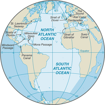
major chokepoints include the Dardanelles, Strait of Gibraltar, access to the Panama and Suez Canals; strategic straits include the Strait of Dover, Straits of Florida, Mona Passage, The Sound (Oresund), and Windward Passage; the Equator divides the Atlantic Ocean into the North Atlantic Ocean and South Atlantic Ocean -
Government :: Atlantic Ocean
-
Country name: This entry includes all forms of the country's name approved by the US Board on Geographic Names (Italy is used as an example): conventional long form (Italian Republic), conventional short form (Italy), local long form (Repubblica Italiana), local short form (Italia), former (Kingdom of Italy), as well as the abbreviation. Also see the Terminology note.etymology: name derives from the Greek description of the waters beyond the Strait of Gibraltar, Atlantis thalassa, meaning "Sea of Atlas"
-
Economy :: Atlantic Ocean
-
Economy - overview: This entry briefly describes the type of economy, including the degree of market orientation, the level of economic development, the most important natural resources, and the unique areas of specialization. It also characterizes major economic events and policy changes in the most recent 12 months and may include a statement about one or two key future macroeconomic trends.The Atlantic Ocean provides some of the world's most heavily trafficked sea routes, between and within the Eastern and Western Hemispheres. Other economic activity includes the exploitation of natural resources, e.g., fishing, dredging of aragonite sands (The Bahamas), and production of crude oil and natural gas (Caribbean Sea, Gulf of Mexico, and North Sea).Marine fisheries: This entry describes the major fisheries in the world's oceans in terms of the area covered, their ranking in terms of the global catch, the main producing countries, and the principal species caught. Information provided by the Fisheries and Aquaculture Department of the UN Food and Agriculture Organization (FAO).
the Atlantic Ocean fisheries are the second most important in the world accounting for 25%, or 19,735,777 mt, of the global catch in 2016; of the seven regions delineated by the Food and Agriculture Organization in the Atlantic basin, the most important include the following:
Northeast Atlantic region (Region 27) is the third most important in the world producing more than 10% of the global catch or 8,313,901 mt in 2016; the region encompasses the waters north of 36º North latitude and east of 40º West longitude with the major producers including Norway (1,869,403 mt), Iceland (1,067,015 mt), Russia (1,034,743 mt), UK (695,936 mt), and Denmark (664,122 mt); the region includes the historically important fishing grounds of the North Sea, the Baltic Sea, and the Atlantic waters between Greenland, Iceland, and the British Isles; the principal catches include Atlantic cod, haddock, saithe (pollock), Blue Whiting, herring, and mackerel; not all fish caught are for human consumption, half of fish catches in the North Sea are processed as fish oil or fish meal, which are used in animal fodder
Eastern Central Atlantic region (Region 34) is the second most important Atlantic fishery, and seventh largest in the world producing 6% of the global catch or 4,795,171 mt in 2016; the region encompasses the waters between 36º North and 6º South latitude and east of 40º West longitude off the west coast of Africa with the major producers including Morocco (1,407,807 mt), Nigeria (357,099 mt), Mauritania (594,754 mt), Senegal (442,910 mt), Ghana (237,457 mt), Cameroon (205,190 mt), and Sierra Leone (200,000 mt); the principal catches include pilchard, sardinellas, shad, and mackerel
Northwest Atlantic region (Region 21) is the third most important Atlantic fishery and ninth in the world producing a little more than 2% of the global catch and 1,811,436 mt in 2016; it encompasses the waters north of 35º North latitude and west of 42º West longitude including the important fishing grounds over the continental shelf of North America such as the Grand Banks, the Georges Bank, and the Flemish Cap, as well as Baffin Bay with the major producers including the US (917,337 mt), Canada (650,950 mt), and Greenland (171,770 mt); the principal catches include sea scallops, prawns, lobster, herring, and menhaden
Mediterranean and Black Sea region (Region 37) is a minor fishing region representing 1.5% or 1,236,999 mt of the world’s total capture in 2016; the region encompasses all waters east of the Strait of Gibraltar with the major producers including Turkey (301,470 mt), Italy (188,783 mt), Tunisia (113,837 mt), Russia (99,759 mt), and Spain (78,491 mt); the principal catches include European anchovy, European pilchard, Gobies, and clams
FAO map of world fishing regions; used with permission.:PDF
-
Military and Security :: Atlantic Ocean
-
Maritime threats: This entry describes the threat of piracy, as defined in Article 101, UN Convention on the Law of the Sea (UNCLOS), or armed robbery against ships, as defined in Resolution A. 1025 (26) adopted on 2 December 2009 at the 26th Assembly Session of the International Maritime Organization. The entry includes the number of ships on the high seas or in territorial waters that were boarded or attacked by pirates, and the number of crewmen abducted or killed, as compiled by the International Mariti . . . moreWest African piracy more than doubled in 2018 totaling 85 attacks, including all of the six ships highjacked during the year; 13 of the 18 vessels fired upon world-wide occurred in West African waters; Nigerian pirates are very aggresive, operating as far as 200 nm offshore and boarded 29 ships in 2018; the Maritime Administration of the US Department of Transportation has issued a Maritime Advisory (2019-010-Gulf of Guinea-Piracy/Armed Robbery/Kidnapping for Ransom) effective 19 July 2019, which states in part "Piracy, armed robbery, and kidnapping for ransom (KFR) continue to serve as significant threats to U.S. flagged vessels transiting or operating in the Gulf of Guinea (GoG). ...According to the Office of Naval Intelligence’s “Weekly Piracy Reports” 72 reported incidents of piracy and armed robbery at sea occurred in the GoG region this year as of July 9, 2019. Attacks, kidnappings for ransom (KFR), and boardings to steal valuables from the ships and crews are the most common types of incidents with approximately 75 percent of all incidents taking place off Nigeria. During the first six months of 2019, there were 15 kidnapping and 3 hijackings in the GoG."
-
Transportation :: Atlantic Ocean
-
Railways: This entry states the total route length of the railway network and of its component parts by gauge, which is the measure of the distance between the inner sides of the load-bearing rails. The four typical types of gauges are: broad, standard, narrow, and dual. Other gauges are listed under note. Some 60% of the world's railways use the standard gauge of 1.4 m (4.7 ft). Gauges vary by country and sometimes within countries. The choice of gauge during initial construction was mainly in resp . . . moreRoadways: This entry gives the total length of the road network and includes the length of the paved and unpaved portions.Ports and terminals: This entry lists major ports and terminals primarily on the basis of the amount of cargo tonnage shipped through the facilities on an annual basis. In some instances, the number of containers handled or ship visits were also considered. Most ports service multiple classes of vessels including bulk carriers (dry and liquid), break bulk cargoes (goods loaded individually in bags, boxes, crates, or drums; sometimes palletized), containers, roll-on/roll-off, and passenger ships. The listing le . . . moremajor seaport(s): Alexandria (Egypt), Algiers (Algeria), Antwerp (Belgium), Barcelona (Spain), Buenos Aires (Argentina), Casablanca (Morocco), Colon (Panama), Copenhagen (Denmark), Dakar (Senegal), Gdansk (Poland), Hamburg (Germany), Helsinki (Finland), Las Palmas (Canary Islands, Spain), Le Havre (France), Lisbon (Portugal), London (UK), Marseille (France), Montevideo (Uruguay), Montreal (Canada), Naples (Italy), New Orleans (US), New York (US), Oran (Algeria), Oslo (Norway), Peiraiefs or Piraeus (Greece), Rio de Janeiro (Brazil), Rotterdam (Netherlands), Saint Petersburg (Russia), Stockholm (Sweden)Transportation - note: This entry includes miscellaneous transportation information of significance not included elsewhere.Kiel Canal and Saint Lawrence Seaway are two important waterways; significant domestic commercial and recreational use of Intracoastal Waterway on central and south Atlantic seaboard and Gulf of Mexico coast of US; the International Maritime Bureau reports the territorial waters of littoral states and offshore Atlantic waters as high risk for piracy and armed robbery against ships, particularly in the Gulf of Guinea off West Africa; in 2014, 41 commercial vessels were attacked in the Gulf of Guinea with 5 hijacked and 144 crew members taken hostage; hijacked vessels are often disguised and cargoes stolen; crews have been robbed and stores or cargoes stolen
-
Transnational Issues :: Atlantic Ocean
-
Disputes - international: This entry includes a wide variety of situations that range from traditional bilateral boundary disputes to unilateral claims of one sort or another. Information regarding disputes over international terrestrial and maritime boundaries has been reviewed by the US Department of State. References to other situations involving borders or frontiers may also be included, such as resource disputes, geopolitical questions, or irredentist issues; however, inclusion does not necessarily constitute . . . more
some maritime disputes (see littoral states)