Main Content
![A combination of datasets from different satellites makes possible this beautiful 'Blue Marble' view of the Pacific Ocean. The string of islands across the top are the Aleutian chain of Alaska; the Hawaiian islands appear along the bottom. Image courtesy of NASA/Goddard Space Flight Center Scientific Visualization Studio.](../attachments/images/thumb/ZN_017_large.jpg?1528324594)
![Oahu is the most populated of the Hawaiian Islands. Hawaii's capital of Honolulu stretches along its southern shore. Just to the east of Honolulu is Waikiki Beach, with throngs of tourists and dozens of high-rise hotels. Overlooking Waikiki is Diamond Head, a volcanic crater formed some 200,000 years ago (extinct for about 150,000 years). The clouds in the right hand corner of this image are an almost permanent feature of Oahu. Trade winds blowing from the northeast are stopped by the 960 m (3,000 ft) high mountain range, where they rain out most of their moisture. As a result, the windward side of Oahu is usually cloudy, and the leeward side is relatively clear and dry. The large indent in the lower left of the image is Pearl Harbor, site of the Japanese air raid which drew America into World War II. The harbor still serves as a US Navy base. Photo courtesy of NASA.](../attachments/images/thumb/ZN_016_large.jpg?1528324595)
![A view of the island of Hawaii (the Big Island) in the Hawaiian Islands as seen from the International Space Station. The famous volcanic mountain Mauna Loa is visible at frame center. Image courtesy of NASA.](../attachments/images/thumb/ZN_005_large.jpg?1528324596)
![A view of Southern China and the Gulf of Tonkin. At the center-right of the image, circled in a black outline, is the island of Hong Kong. Hong Kong sits on the South China Sea, which is mostly under cloud cover in this image. West of the South China Sea is the island of Hainan, seen at bottom-center, which separates the sea from the Gulf of Tonkin to the west. In this image, the Gulf of Tonkin is saturated with what seems to be a mixture of sediment and phytoplankton. Photo courtesy of NASA.](../attachments/images/thumb/ZN_015_large.jpg?1528324596)
![A dust plume arose over Inner Mongolia and on April 9, 2012, began its eastward journey over the Sea of Japan. New research shows that dust accounts for most of the 64 million tons of foreign aerosol imports that arrive in the air over North America each year. Credit: NASA Earth Observatory/Jeff Schmaltz.](../attachments/images/thumb/ZN_018_large.jpg?1528324598)
![With the Seward Peninsula of Alaska to the east, and Chukotskiy Poluostrov of Siberia to the west, the Bering Strait separates the United States and the Russian Federation by only 90 km (55 mi). It is named for Danish explorer Vitus Bering, who spotted the Alaskan mainland in 1741 while leading an expedition of Russian sailors. The boundary between the US and Russia lies between Big and Little Diomede Islands, which are visible in the middle of the Bering Strait. At the bottom of this image is St. Lawrence Island. Situated in the Bering Sea, it is part of Alaska. Image courtesy of NASA.](../attachments/images/thumb/ZN_004_large.jpg?1528324598)
![A view of two of the Mariana Islands as seen from the space shuttle - Saipan (to the north) and Tinian. Image courtesy of NASA.](../attachments/images/thumb/ZN_007_large.jpg?1528324599)
![The largest of the three Volcano Islands, Iwo Jima is seen here from the north. The island is about 8 km (5 mi) long and 4 km (2.5 mi) wide, and covers an area of 21 sq km (8 sq mi). Mount Suribachi (167 m; 546 ft high), on the south side of the island, is an extinct volcano. Iwo Jima was the scene of one of the bloodiest battles in the Pacific Theater of World War II. Image courtesy of NASA.](../attachments/images/thumb/ZN_011_large.jpg?1528324600)
![Considered by many as one of the natural wonders of the world, the island of Bora-Bora is a single island surrounded by an extensive coral reef and a beautiful blue lagoon captured in the center of this low-oblique photograph. The coral reef north of Bora-Bora is Tupai Atoll. The two islands southeast of Bora-Bora - Tahaa (northern island) and Raiatea (larger southern island) - are encircled by a single coral reef system. Image courtesy of NASA.](../attachments/images/thumb/ZN_014_large.jpg?1528324601)
![The tropical island of Moorea as viewed from the International Space Station. The barrier reefs surrounding the island create zones of shallow, tranquil light blue waters. Image courtesy of NASA.](../attachments/images/thumb/ZN_010_large.jpg?1528324601)
![Easter Island, one of the most remote locations on Earth, is more than 3,200 km (2,000 mi) from the closest populations on Tahiti or Chile. Less than 25 km (15 mi) long, the island is dominated by volcanic landforms, including the large crater Rana Kao at the southwest end of the island and a line of cinder cones that stretch north from the central mountain. A final feature (difficult to see) is the very long runway (Chile's longest) near Rana Kao. The airport serves as an emergency space shuttle landing site. Image courtesy of NASA.](../attachments/images/thumb/ZN_009_large.jpg?1528324602)
![The two westernmost islands of the Galapagos archipelago. The largest of the group, Isabela, stretches across most of the frame. It was created from the merger of six shield volcanoes, several of which are visible in this view. The northernmost and highest, Volcano Wolf (1,707 m or 5,600 ft), lies directly on the equator. The smaller island of Fernandina displays a single volcanic cone. Image courtesy of NASA.](../attachments/images/thumb/ZN_006_large.jpg?1528324602)
![Millennium Island - known as Caroline Island prior to 2000 - is located at the southern end of the Line Islands, which make up the western portion of Kiribati. Uninhabited Millennium Island is formed from a number of smaller islets built on coral reefs. The reefs grew around a now-submerged volcanic peak, leaving a ring of coral around an inner lagoon. The shallow lagoon waters are a lighter blue than the deeper surrounding ocean water; tan linear "fingers" within the lagoon are the tops of corals. The two largest islets are Nake Islet (on the north) and South Islet. Image courtesy of NASA.](../attachments/images/thumb/ZN_008_large.jpg?1528324603)
![Kiritimati Island (formerly Christmas Island), the largest atoll in the Pacific Ocean, is the centerpiece of this low-oblique, northeast-looking photo. The atoll covers 606 sq km (234 sq mi), of which 243 sq km (94 sq mi) are land. The island was discovered by Captain James Cook in 1777. The majority of the island's inhabitants work on coconut plantations and in copra production. The island's major airbase is on the northeast side of the island. Nuclear tests were conducted on Kiritimati Island by the British in 1957 and 1958 and by the United States in 1962. Image courtesy of NASA.](../attachments/images/thumb/ZN_012_large.jpg?1528324603)
![View of the northern portion of New Caledonia. The world's second largest barrier reef encircles the island. Image courtesy of NASA.](../attachments/images/thumb/ZN_013_large.jpg?1528324604)
![A sun glint in the southwestern Pacific Ocean, as photographed from an Apollo spacecraft. The island is Bougainville of the Solomon Islands group. The horizon of the Earth is in the background. The picture was taken at an altitude of 231 km (143 mi). Photo courtesy of NASA.](../attachments/images/thumb/ZN_003_large.jpg?1528324605)
![Nukuoro Atoll, Federated States of Micronesia,as seen from the International Space Station. Image courtesy of NASA.](../attachments/images/thumb/ZN_002_large.jpg?1528324605)
![Atafu Atoll in the Southern Pacific Ocean is featured in this image photographed from the International Space Station. At roughly eight kilometers wide, Atafu Atoll is the smallest of three atolls comprising the Tokelau Islands group located in the Southern Pacific Ocean. Image courtesy of NASA.](../attachments/images/thumb/ZN_001_large.jpg?1528324606)
![A combination of datasets from different satellites makes possible this beautiful 'Blue Marble' view of the Pacific Ocean. The string of islands across the top are the Aleutian chain of Alaska; the Hawaiian islands appear along the bottom. Image courtesy of NASA/Goddard Space Flight Center Scientific Visualization Studio.](../attachments/images/large/ZN_017_large.jpg?1528324594)
Agency Copyright Notice
![Oahu is the most populated of the Hawaiian Islands. Hawaii's capital of Honolulu stretches along its southern shore. Just to the east of Honolulu is Waikiki Beach, with throngs of tourists and dozens of high-rise hotels. Overlooking Waikiki is Diamond Head, a volcanic crater formed some 200,000 years ago (extinct for about 150,000 years). The clouds in the right hand corner of this image are an almost permanent feature of Oahu. Trade winds blowing from the northeast are stopped by the 960 m (3,000 ft) high mountain range, where they rain out most of their moisture. As a result, the windward side of Oahu is usually cloudy, and the leeward side is relatively clear and dry. The large indent in the lower left of the image is Pearl Harbor, site of the Japanese air raid which drew America into World War II. The harbor still serves as a US Navy base. Photo courtesy of NASA.](../attachments/images/large/ZN_016_large.jpg?1528324595)
Agency Copyright Notice
![A view of the island of Hawaii (the Big Island) in the Hawaiian Islands as seen from the International Space Station. The famous volcanic mountain Mauna Loa is visible at frame center. Image courtesy of NASA.](../attachments/images/large/ZN_005_large.jpg?1528324596)
Agency Copyright Notice
![A view of Southern China and the Gulf of Tonkin. At the center-right of the image, circled in a black outline, is the island of Hong Kong. Hong Kong sits on the South China Sea, which is mostly under cloud cover in this image. West of the South China Sea is the island of Hainan, seen at bottom-center, which separates the sea from the Gulf of Tonkin to the west. In this image, the Gulf of Tonkin is saturated with what seems to be a mixture of sediment and phytoplankton. Photo courtesy of NASA.](../attachments/images/large/ZN_015_large.jpg?1528324596)
Agency Copyright Notice
![A dust plume arose over Inner Mongolia and on April 9, 2012, began its eastward journey over the Sea of Japan. New research shows that dust accounts for most of the 64 million tons of foreign aerosol imports that arrive in the air over North America each year. Credit: NASA Earth Observatory/Jeff Schmaltz.](../attachments/images/large/ZN_018_large.jpg?1528324598)
Agency Copyright Notice
![With the Seward Peninsula of Alaska to the east, and Chukotskiy Poluostrov of Siberia to the west, the Bering Strait separates the United States and the Russian Federation by only 90 km (55 mi). It is named for Danish explorer Vitus Bering, who spotted the Alaskan mainland in 1741 while leading an expedition of Russian sailors. The boundary between the US and Russia lies between Big and Little Diomede Islands, which are visible in the middle of the Bering Strait. At the bottom of this image is St. Lawrence Island. Situated in the Bering Sea, it is part of Alaska. Image courtesy of NASA.](../attachments/images/large/ZN_004_large.jpg?1528324598)
Agency Copyright Notice
![A view of two of the Mariana Islands as seen from the space shuttle - Saipan (to the north) and Tinian. Image courtesy of NASA.](../attachments/images/large/ZN_007_large.jpg?1528324599)
Agency Copyright Notice
![The largest of the three Volcano Islands, Iwo Jima is seen here from the north. The island is about 8 km (5 mi) long and 4 km (2.5 mi) wide, and covers an area of 21 sq km (8 sq mi). Mount Suribachi (167 m; 546 ft high), on the south side of the island, is an extinct volcano. Iwo Jima was the scene of one of the bloodiest battles in the Pacific Theater of World War II. Image courtesy of NASA.](../attachments/images/large/ZN_011_large.jpg?1528324600)
Agency Copyright Notice
![Considered by many as one of the natural wonders of the world, the island of Bora-Bora is a single island surrounded by an extensive coral reef and a beautiful blue lagoon captured in the center of this low-oblique photograph. The coral reef north of Bora-Bora is Tupai Atoll. The two islands southeast of Bora-Bora - Tahaa (northern island) and Raiatea (larger southern island) - are encircled by a single coral reef system. Image courtesy of NASA.](../attachments/images/large/ZN_014_large.jpg?1528324601)
Agency Copyright Notice
![The tropical island of Moorea as viewed from the International Space Station. The barrier reefs surrounding the island create zones of shallow, tranquil light blue waters. Image courtesy of NASA.](../attachments/images/large/ZN_010_large.jpg?1528324601)
Agency Copyright Notice
![Easter Island, one of the most remote locations on Earth, is more than 3,200 km (2,000 mi) from the closest populations on Tahiti or Chile. Less than 25 km (15 mi) long, the island is dominated by volcanic landforms, including the large crater Rana Kao at the southwest end of the island and a line of cinder cones that stretch north from the central mountain. A final feature (difficult to see) is the very long runway (Chile's longest) near Rana Kao. The airport serves as an emergency space shuttle landing site. Image courtesy of NASA.](../attachments/images/large/ZN_009_large.jpg?1528324602)
Agency Copyright Notice
![The two westernmost islands of the Galapagos archipelago. The largest of the group, Isabela, stretches across most of the frame. It was created from the merger of six shield volcanoes, several of which are visible in this view. The northernmost and highest, Volcano Wolf (1,707 m or 5,600 ft), lies directly on the equator. The smaller island of Fernandina displays a single volcanic cone. Image courtesy of NASA.](../attachments/images/large/ZN_006_large.jpg?1528324602)
Agency Copyright Notice
![Millennium Island - known as Caroline Island prior to 2000 - is located at the southern end of the Line Islands, which make up the western portion of Kiribati. Uninhabited Millennium Island is formed from a number of smaller islets built on coral reefs. The reefs grew around a now-submerged volcanic peak, leaving a ring of coral around an inner lagoon. The shallow lagoon waters are a lighter blue than the deeper surrounding ocean water; tan linear "fingers" within the lagoon are the tops of corals. The two largest islets are Nake Islet (on the north) and South Islet. Image courtesy of NASA.](../attachments/images/large/ZN_008_large.jpg?1528324603)
Agency Copyright Notice
![Kiritimati Island (formerly Christmas Island), the largest atoll in the Pacific Ocean, is the centerpiece of this low-oblique, northeast-looking photo. The atoll covers 606 sq km (234 sq mi), of which 243 sq km (94 sq mi) are land. The island was discovered by Captain James Cook in 1777. The majority of the island's inhabitants work on coconut plantations and in copra production. The island's major airbase is on the northeast side of the island. Nuclear tests were conducted on Kiritimati Island by the British in 1957 and 1958 and by the United States in 1962. Image courtesy of NASA.](../attachments/images/large/ZN_012_large.jpg?1528324603)
Agency Copyright Notice
![View of the northern portion of New Caledonia. The world's second largest barrier reef encircles the island. Image courtesy of NASA.](../attachments/images/large/ZN_013_large.jpg?1528324604)
Agency Copyright Notice
![A sun glint in the southwestern Pacific Ocean, as photographed from an Apollo spacecraft. The island is Bougainville of the Solomon Islands group. The horizon of the Earth is in the background. The picture was taken at an altitude of 231 km (143 mi). Photo courtesy of NASA.](../attachments/images/large/ZN_003_large.jpg?1528324605)
Agency Copyright Notice
![Nukuoro Atoll, Federated States of Micronesia,as seen from the International Space Station. Image courtesy of NASA.](../attachments/images/large/ZN_002_large.jpg?1528324605)
Agency Copyright Notice
![Atafu Atoll in the Southern Pacific Ocean is featured in this image photographed from the International Space Station. At roughly eight kilometers wide, Atafu Atoll is the smallest of three atolls comprising the Tokelau Islands group located in the Southern Pacific Ocean. Image courtesy of NASA.](../attachments/images/large/ZN_001_large.jpg?1528324606)
Agency Copyright Notice
- Jump to topic
-
Introduction :: Pacific Ocean
-
Background: This entry usually highlights major historic events and current issues and may include a statement about one or two key future trends.
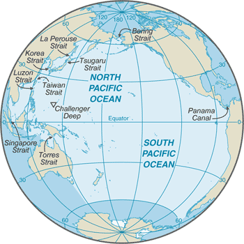
The Pacific Ocean is the largest of the world's five oceans (followed by the Atlantic Ocean, Indian Ocean, Southern Ocean, and Arctic Ocean). Strategically important access waterways include the La Perouse, Tsugaru, Tsushima, Taiwan, Singapore, and Torres Straits.The decision by the International Hydrographic Organization in the spring of 2000 to delimit a fifth ocean, the Southern Ocean, removed the portion of the Pacific Ocean south of 60 degrees south.
-
Geography :: Pacific Ocean
-
Location: This entry identifies the country's regional location, neighboring countries, and adjacent bodies of water.body of water between the Southern Ocean, Asia, Australia, and the Western HemisphereGeographic coordinates: This entry includes rounded latitude and longitude figures for the centroid or center point of a country expressed in degrees and minutes; it is based on the locations provided in the Geographic Names Server (GNS), maintained by the National Geospatial-Intelligence Agency on behalf of the US Board on Geographic Names.0 00 N, 160 00 WMap references: This entry includes the name of the Factbook reference map on which a country may be found. Note that boundary representations on these maps are not necessarily authoritative. The entry on Geographic coordinates may be helpful in finding some smaller countries.Political Map of the WorldArea: This entry includes three subfields. Total area is the sum of all land and water areas delimited by international boundaries and/or coastlines. Land area is the aggregate of all surfaces delimited by international boundaries and/or coastlines, excluding inland water bodies (lakes, reservoirs, rivers). Water area is the sum of the surfaces of all inland water bodies, such as lakes, reservoirs, or rivers, as delimited by international boundaries and/or coastlines.total: 155.557 million sq km
note: includes Bali Sea, Bering Sea, Bering Strait, Coral Sea, East China Sea, Gulf of Alaska, Gulf of Tonkin, Philippine Sea, Sea of Japan, Sea of Okhotsk, South China Sea, Tasman Sea, and other tributary water bodies
Area - comparative: This entry provides an area comparison based on total area equivalents. Most entities are compared with the entire US or one of the 50 states based on area measurements (1990 revised) provided by the US Bureau of the Census. The smaller entities are compared with Washington, DC (178 sq km, 69 sq mi) or The Mall in Washington, DC (0.59 sq km, 0.23 sq mi, 146 acres).about 15 times the size of the US; covers about 28% of the global surface; almost equal to the total land area of the worldCoastline: This entry gives the total length of the boundary between the land area (including islands) and the sea.135,663 kmClimate: This entry includes a brief description of typical weather regimes throughout the year; in the Word entry only, it includes four subfields that describe climate extremes:ten driest places on earth (average annual precipitation) describes the annual average precipitation measured in both millimeters and inches for selected countries with climate extremes. ten wettest places on earth (average annual precipitation) describes the annual average precipitation measured in both millimeters and i . . . moreplanetary air pressure systems and resultant wind patterns exhibit remarkable uniformity in the south and east; trade winds and westerly winds are well-developed patterns, modified by seasonal fluctuations; tropical cyclones (hurricanes) may form south of Mexico from June to October and affect Mexico and Central America; continental influences cause climatic uniformity to be much less pronounced in the eastern and western regions at the same latitude in the North Pacific Ocean; the western Pacific is monsoonal - a rainy season occurs during the summer months, when moisture-laden winds blow from the ocean over the land, and a dry season during the winter months, when dry winds blow from the Asian landmass back to the ocean; tropical cyclones (typhoons) may strike southeast and east Asia from May to DecemberTerrain: This entry contains a brief description of the topography.surface dominated by two large gyres (broad, circular systems of currents), one in the northern Pacific and another in the southern Pacific; in the northern Pacific, sea ice forms in the Bering Sea and Sea of Okhotsk in winter; in the southern Pacific, sea ice from Antarctica reaches its northernmost extent in October; the ocean floor in the eastern Pacific is dominated by the East Pacific Rise, while the western Pacific is dissected by deep trenches, including the Mariana Trench, which is the world's deepest at 10,924 m
major surface currents: clockwise North Pacific Gyre formed by the warm northward flowing Kuroshio Current in the west, the eastward flowing North Pacific Current in the north, the southward flowing cold California Current in the east, and the westward flowing North Equatorial Current in the south; the counterclockwise South Pacific Gyre composed of the southward flowing warm East Australian Current in the west, the eastward flowing South Pacific Current in the south, the northward flowing cold Peru (Humbolt) Current in the east, and the westward flowing South Equatorial Current in the north
Elevation: This entry includes the mean elevation and elevation extremes, lowest point and highest point.mean depth: -2,970 mlowest point: Challenger Deep in the Mariana Trench -10,924 mhighest point: sea levelNatural resources: This entry lists a country's mineral, petroleum, hydropower, and other resources of commercial importance, such as rare earth elements (REEs). In general, products appear only if they make a significant contribution to the economy, or are likely to do so in the future.oil and gas fields, polymetallic nodules, sand and gravel aggregates, placer deposits, fishNatural hazards: This entry lists potential natural disasters. For countries where volcanic activity is common, a volcanism subfield highlights historically active volcanoes.surrounded by a zone of violent volcanic and earthquake activity sometimes referred to as the "Pacific Ring of Fire"; subject to tropical cyclones (typhoons) in southeast and east Asia from May to December (most frequent from July to October); tropical cyclones (hurricanes) may form south of Mexico and strike Central America and Mexico from June to October (most common in August and September); cyclical El Nino/La Nina phenomenon occurs in the equatorial Pacific, influencing weather in the Western Hemisphere and the western Pacific;ships subject to superstructure icing in extreme north from October to May; persistent fog in the northern Pacific can be a maritime hazard from June to DecemberEnvironment - current issues: This entry lists the most pressing and important environmental problems. The following terms and abbreviations are used throughout the entry: Acidification - the lowering of soil and water pH due to acid precipitation and deposition usually through precipitation; this process disrupts ecosystem nutrient flows and may kill freshwater fish and plants dependent on more neutral or alkaline conditions (see acid rain). Acid rain - characterized as containing harmful levels of sulfur dioxi . . . morepollution (such as sewage, runoff from land and toxic waste); habitat destruction; over-fishing; climate change leading to sea level rise, ocean acidification, and warming; endangered marine species include the dugong, sea lion, sea otter, seals, turtles, and whales; oil pollution in Philippine Sea and South China SeaGeography - note: This entry includes miscellaneous geographic information of significance not included elsewhere.the major chokepoints are the Bering Strait, Panama Canal, Luzon Strait, and the Singapore Strait; the Equator divides the Pacific Ocean into the North Pacific Ocean and the South Pacific Ocean; dotted with low coral islands and rugged volcanic islands in the southwestern Pacific Ocean; much of the Pacific Ocean's rim lies along the Ring of Fire, a belt of active volcanoes and earthquake epicenters that accounts for up to 90% of the world's earthquakes and some 75% of the world's volcanoes -
Government :: Pacific Ocean
-
Country name: This entry includes all forms of the country's name approved by the US Board on Geographic Names (Italy is used as an example): conventional long form (Italian Republic), conventional short form (Italy), local long form (Repubblica Italiana), local short form (Italia), former (Kingdom of Italy), as well as the abbreviation. Also see the Terminology note.etymology: named by Portuguese explorer Ferdinand MAGELLAN during the Spanish circumnavigation of the world in 1521; encountering favorable winds upon reaching the ocean, he called it "Mar Pacifico," which means "peaceful sea" in both Portuguese and Spanish
-
Economy :: Pacific Ocean
-
Economy - overview: This entry briefly describes the type of economy, including the degree of market orientation, the level of economic development, the most important natural resources, and the unique areas of specialization. It also characterizes major economic events and policy changes in the most recent 12 months and may include a statement about one or two key future macroeconomic trends.The Pacific Ocean is a major contributor to the world economy and particularly to those nations its waters directly touch. It provides low-cost sea transportation between East and West, extensive fishing grounds, offshore oil and gas fields, minerals, and sand and gravel for the construction industry. In 1996, over 60% of the world's fish catch came from the Pacific Ocean. Exploitation of offshore oil and gas reserves is playing an ever-increasing role in the energy supplies of the US, Australia, NZ, China, and Peru. The high cost of recovering offshore oil and gas, combined with the wide swings in world prices for oil since 1985, has led to fluctuations in new drillings.Marine fisheries: This entry describes the major fisheries in the world's oceans in terms of the area covered, their ranking in terms of the global catch, the main producing countries, and the principal species caught. Information provided by the Fisheries and Aquaculture Department of the UN Food and Agriculture Organization (FAO).
the Pacific Ocean fisheries are the most important in the world accounting for 59%, or 46,706,536 mt, of the global marine capture in 2016; of the six regions delineated by the Food and Agriculture Organization in the Pacific Ocean, the following are the most important:
Northwest Pacific region (Region 61) is the world’s most important fishery producing 28% of the global catch or 22,411,224 mt in 2016; it encompasses the waters north of 20º north latitude and west of 175º west longitude with the major producers including China (14,776,769 mt), Japan (2,896,073 mt), South Korea (944,558 mt), and Taiwan (378,990 mt); the principal catches include Alaska Pollock, Japanese anchovy, chub mackerel, and scads
Western Central Pacific region (Region 71) is the world’s second most important fishing region producing 16%, or 12,742,955 mt, of the global catch in 2016; tuna is the most important species in this region; the region includes the waters between 20º North and 25º South latitude and west of 175º West longitude with the major producers including Indonesia (4,704,382 mt), Vietnam (2,678,406 mt), Philippines (1,865,213 mt), Thailand (950,219 mt), and Malaysia (792,163 mt); the principal catches include Skipjack and Yellowfin tuna, sardinellas, and cephalopods
Southeast Pacific region (Region 87) is the third major Pacific fishery and fifth largest in the world producing 8%, or 6,329,328 mt, of the global catch in 2016; this region includes the nutrient rich upwelling waters off the west coast of South America between 5º North and 60º South latitude and east of 120º West longitude with the major producers including Peru (3,774,887 mt), Chile (1,495,359 mt), and Ecuador (612,755 mt); the principal catches include Peruvian anchovy (50% of the catch), Jumbo flying squid, and Chilean jack mackerel
Pacific Northeast region (Region 67) is the fourth largest Pacific Ocean fishery and eighth largest in the world producing 4% of the global catch or 3,092,529 mt in 2016; this region encompasses the waters north of 40º North latitude and east of 175º West longitude including the Gulf of Alaska and Bering Sea with the major producers including the US (2,900,835 mt), Canada (180,664 mt), and Russia (11,030 mt); the principal catches include Alaska pollock, Pacific cod, and North Pacific hakeFAO map of world fishing regions; used with permission.:PDF
-
Military and Security :: Pacific Ocean
-
Maritime threats: This entry describes the threat of piracy, as defined in Article 101, UN Convention on the Law of the Sea (UNCLOS), or armed robbery against ships, as defined in Resolution A. 1025 (26) adopted on 2 December 2009 at the 26th Assembly Session of the International Maritime Organization. The entry includes the number of ships on the high seas or in territorial waters that were boarded or attacked by pirates, and the number of crewmen abducted or killed, as compiled by the International Mariti . . . morethe International Maritime Bureau reports the territorial waters of littoral states and offshore waters in the South China Sea as high risk for piracy and armed robbery against ships; an emerging threat area lies in the Celebes and Sulu Seas between the Philippines and Malaysia where three crew were kidnapped or taken hostage in 2018; numerous commercial vessels have been attacked and hijacked both at anchor and while underway; hijacked vessels are often disguised and cargoes stolen; crew and passengers are often held for ransom, murdered, or cast adrift; the Maritime Administration (MARAD) of the US Department of Transportation has issued a Maritime Advisory (2019-011-Sulu and Celebes Seas-Piracy/Armed Robbery/Terrorism) which states in part "In 2018, there were at least 12 reported boardings, attempted boardings, attacks, hijackings, and kidnappings in the Sulu and Celebes Seas. Recent kidnapping incidents in this area were reportedly linked to the Abu Sayyaf Group (ASG), a violent Islamic separatist group operating in the southern Philippines..." and advises ships to adhere to counter-piracy practices to minimize risk
-
Transportation :: Pacific Ocean
-
Roadways: This entry gives the total length of the road network and includes the length of the paved and unpaved portions.Ports and terminals: This entry lists major ports and terminals primarily on the basis of the amount of cargo tonnage shipped through the facilities on an annual basis. In some instances, the number of containers handled or ship visits were also considered. Most ports service multiple classes of vessels including bulk carriers (dry and liquid), break bulk cargoes (goods loaded individually in bags, boxes, crates, or drums; sometimes palletized), containers, roll-on/roll-off, and passenger ships. The listing le . . . moremajor seaport(s): Bangkok (Thailand), Hong Kong (China), Kao-hsiung (Taiwan), Los Angeles (US), Manila (Philippines), Pusan (South Korea), San Francisco (US), Seattle (US), Shanghai (China), Singapore, Sydney (Australia), Vladivostok (Russia), Wellington (NZ), Yokohama (Japan)
-
Transnational Issues :: Pacific Ocean
-
Disputes - international: This entry includes a wide variety of situations that range from traditional bilateral boundary disputes to unilateral claims of one sort or another. Information regarding disputes over international terrestrial and maritime boundaries has been reviewed by the US Department of State. References to other situations involving borders or frontiers may also be included, such as resource disputes, geopolitical questions, or irredentist issues; however, inclusion does not necessarily constitute . . . more
some maritime disputes (see littoral states)